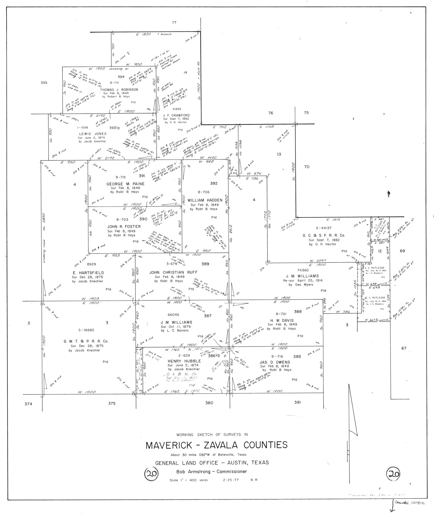
Maverick County Working Sketch 20
-
Map/Doc
70912
-
Collection
General Map Collection
-
Object Dates
2/25/1977 (Creation Date)
-
People and Organizations
Beverly Robison (Draftsman)
-
Counties
Maverick Zavala
-
Subjects
Surveying Working Sketch
-
Height x Width
26.1 x 22.0 inches
66.3 x 55.9 cm
-
Scale
1" = 400 varas
Part of: General Map Collection
Montgomery County Working Sketch 13

Print $20.00
- Digital $50.00
Montgomery County Working Sketch 13
1934
Size 24.4 x 30.4 inches
Map/Doc 71120
Harris County Working Sketch 8

Print $20.00
- Digital $50.00
Harris County Working Sketch 8
1904
Size 26.8 x 23.3 inches
Map/Doc 65900
Wilbarger County Sketch File 5a

Print $20.00
- Digital $50.00
Wilbarger County Sketch File 5a
Size 13.4 x 19.7 inches
Map/Doc 12690
Gillespie County Working Sketch 5

Print $20.00
- Digital $50.00
Gillespie County Working Sketch 5
1972
Size 25.7 x 25.9 inches
Map/Doc 63168
Monterey Harbor, California

Print $20.00
- Digital $50.00
Monterey Harbor, California
1852
Size 15.7 x 13.8 inches
Map/Doc 97230
Reagan County Rolled Sketch 34

Print $40.00
- Digital $50.00
Reagan County Rolled Sketch 34
1956
Size 53.2 x 40.3 inches
Map/Doc 9829
Panola County Sketch File 2

Print $4.00
- Digital $50.00
Panola County Sketch File 2
1851
Size 10.8 x 8.2 inches
Map/Doc 33447
Crane County Rolled Sketch 15

Print $40.00
- Digital $50.00
Crane County Rolled Sketch 15
1946
Size 27.2 x 49.5 inches
Map/Doc 8682
North Part of El Paso Co.

Print $20.00
- Digital $50.00
North Part of El Paso Co.
1977
Size 35.7 x 46.3 inches
Map/Doc 73141
Crockett County Working Sketch 36

Print $20.00
- Digital $50.00
Crockett County Working Sketch 36
1927
Size 22.4 x 26.0 inches
Map/Doc 68369
Blanco County Sketch File 31

Print $4.00
- Digital $50.00
Blanco County Sketch File 31
Size 11.1 x 8.6 inches
Map/Doc 14629
Flight Mission No. BQR-13K, Frame 117, Brazoria County

Print $20.00
- Digital $50.00
Flight Mission No. BQR-13K, Frame 117, Brazoria County
1952
Size 18.6 x 22.4 inches
Map/Doc 84078
You may also like
Brewster County Rolled Sketch 95

Print $20.00
- Digital $50.00
Brewster County Rolled Sketch 95
1947
Size 29.4 x 38.0 inches
Map/Doc 5252
Liberty County Working Sketch 62

Print $20.00
- Digital $50.00
Liberty County Working Sketch 62
1969
Size 22.1 x 28.3 inches
Map/Doc 70522
Reagan County Boundary File 1

Print $8.00
- Digital $50.00
Reagan County Boundary File 1
Size 8.8 x 8.9 inches
Map/Doc 58151
Terry County Sketch File 10

Print $20.00
- Digital $50.00
Terry County Sketch File 10
Size 10.8 x 43.2 inches
Map/Doc 10394
Dawson County Sketch File 21

Print $20.00
- Digital $50.00
Dawson County Sketch File 21
1953
Size 12.2 x 24.5 inches
Map/Doc 11297
Palo Pinto County Working Sketch 1

Print $20.00
- Digital $50.00
Palo Pinto County Working Sketch 1
1903
Size 19.0 x 14.6 inches
Map/Doc 71384
Coke County Working Sketch 10

Print $20.00
- Digital $50.00
Coke County Working Sketch 10
1937
Size 25.1 x 26.7 inches
Map/Doc 68047
Upshur County Rolled Sketch 3

Print $20.00
- Digital $50.00
Upshur County Rolled Sketch 3
1965
Size 35.3 x 30.0 inches
Map/Doc 8062
Post City and Surroundings Showing Improvements and 4 Sec. Pastures

Print $20.00
- Digital $50.00
Post City and Surroundings Showing Improvements and 4 Sec. Pastures
1911
Size 36.4 x 29.8 inches
Map/Doc 90858
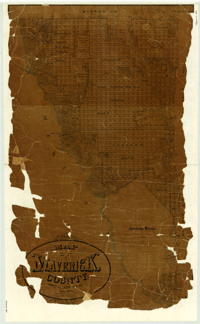
Map of Maverick County
Print $20.00
- Digital $50.00
Map of Maverick County
1892
Size 34.4 x 21.2 inches
Map/Doc 3852
Flight Mission No. DCL-6C, Frame 126, Kenedy County

Print $20.00
- Digital $50.00
Flight Mission No. DCL-6C, Frame 126, Kenedy County
1943
Size 18.5 x 22.3 inches
Map/Doc 85956
Henderson County Sketch File 12

Print $8.00
- Digital $50.00
Henderson County Sketch File 12
1871
Size 8.4 x 7.4 inches
Map/Doc 26349