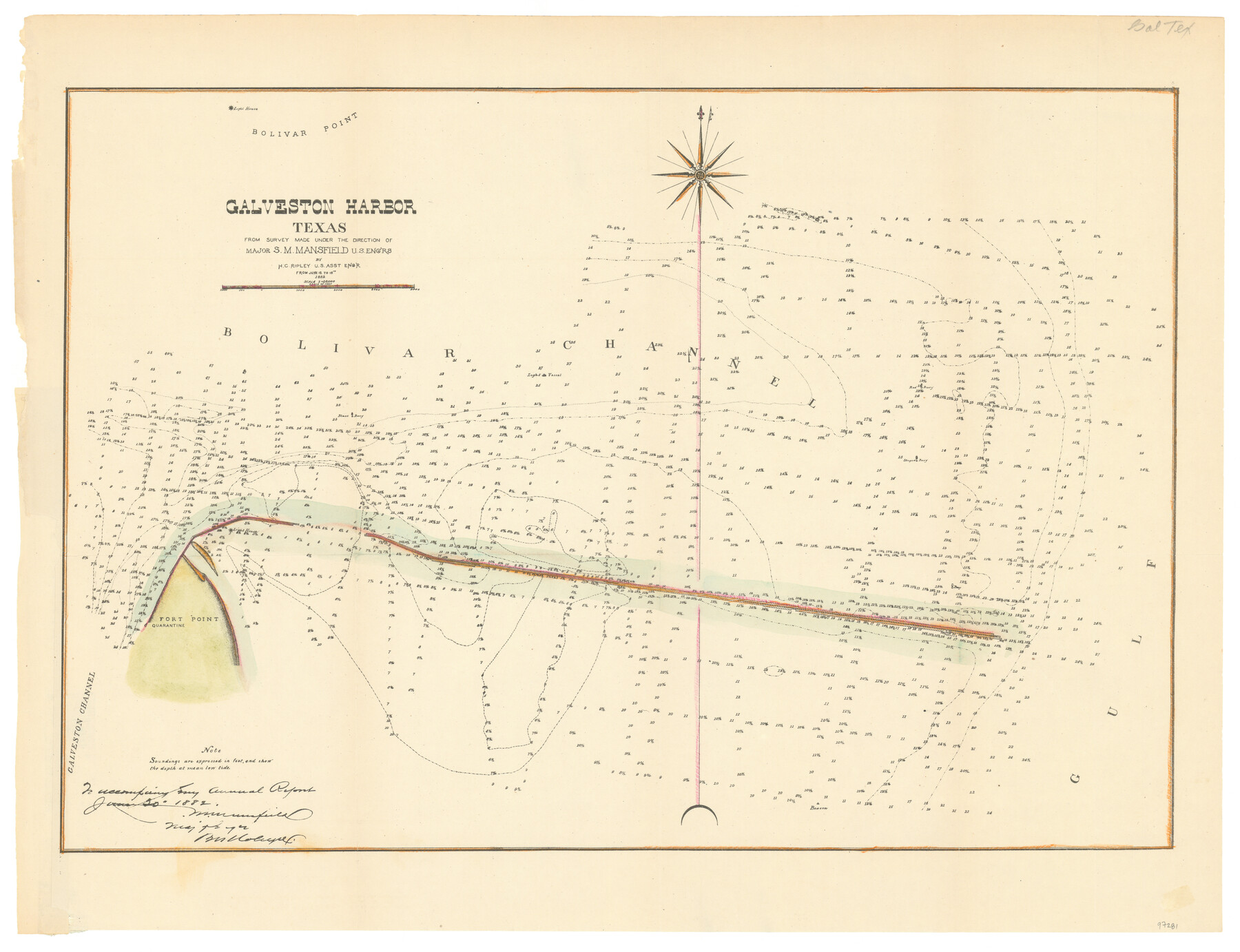
Galveston Harbor, Texas
-
Map/Doc
97281
-
Collection
General Map Collection
-
Object Dates
1882 (Creation Date)
-
People and Organizations
S.M. Mansfield (Surveyor/Engineer)
H.C. Ripley (Surveyor/Engineer)
Chase Untermeyer (Donor)
-
Subjects
Coastal Nautical Charts
-
Height x Width
15.0 x 19.5 inches
38.1 x 49.5 cm
-
Comments
Donated by Ambassador Chase Untermeyer in June 2024.
Part of: General Map Collection
Flight Mission No. BQR-3K, Frame 156, Brazoria County

Print $20.00
- Digital $50.00
Flight Mission No. BQR-3K, Frame 156, Brazoria County
1952
Size 18.6 x 22.4 inches
Map/Doc 83983

Map of Ramon Musquiz Survey, Meanders of Lavaca & Navidad Rivers, Menefee & Redfish Lakes

Print $20.00
- Digital $50.00
Map of Ramon Musquiz Survey, Meanders of Lavaca & Navidad Rivers, Menefee & Redfish Lakes
1934
Size 23.4 x 18.4 inches
Map/Doc 65455
Flight Mission No. DAG-24K, Frame 146, Matagorda County

Print $20.00
- Digital $50.00
Flight Mission No. DAG-24K, Frame 146, Matagorda County
1953
Size 18.6 x 22.2 inches
Map/Doc 86560
Treaty to Resolve Pending Boundary Differences and Maintain the Rio Grande and Colorado River as the International Boundary Between the United States of American and Mexico

Print $4.00
- Digital $50.00
Treaty to Resolve Pending Boundary Differences and Maintain the Rio Grande and Colorado River as the International Boundary Between the United States of American and Mexico
1970
Size 12.1 x 19.0 inches
Map/Doc 83099
The City of Austin and Suburbs

Print $40.00
- Digital $50.00
The City of Austin and Suburbs
1919
Size 120.7 x 41.2 inches
Map/Doc 88863
Brewster County Sketch File 54

Print $4.00
- Digital $50.00
Brewster County Sketch File 54
1963
Size 11.0 x 8.5 inches
Map/Doc 16383
Flight Mission No. BRA-8M, Frame 127, Jefferson County

Print $20.00
- Digital $50.00
Flight Mission No. BRA-8M, Frame 127, Jefferson County
1953
Size 18.6 x 22.3 inches
Map/Doc 85623
Kleberg County Rolled Sketch 10-36

Print $20.00
- Digital $50.00
Kleberg County Rolled Sketch 10-36
1952
Size 35.3 x 30.7 inches
Map/Doc 9382
Map of Jasper District

Print $20.00
- Digital $50.00
Map of Jasper District
1847
Size 32.8 x 29.6 inches
Map/Doc 3713
Pecos County Working Sketch 69

Print $40.00
- Digital $50.00
Pecos County Working Sketch 69
1956
Size 48.7 x 32.6 inches
Map/Doc 71541
Webb County Working Sketch 30

Print $20.00
- Digital $50.00
Webb County Working Sketch 30
1934
Size 15.0 x 40.6 inches
Map/Doc 72395
You may also like
Flight Mission No. DIX-5P, Frame 147, Aransas County

Print $20.00
- Digital $50.00
Flight Mission No. DIX-5P, Frame 147, Aransas County
1956
Size 17.8 x 18.1 inches
Map/Doc 83809
[Sketch for Mineral Application 24072, San Jacinto River]
![65585, [Sketch for Mineral Application 24072, San Jacinto River], General Map Collection](https://historictexasmaps.com/wmedia_w700/maps/65585.tif.jpg)
Print $20.00
- Digital $50.00
[Sketch for Mineral Application 24072, San Jacinto River]
1929
Size 21.7 x 11.1 inches
Map/Doc 65585
Kinney County

Print $40.00
- Digital $50.00
Kinney County
1955
Size 50.5 x 47.0 inches
Map/Doc 73209
Bandera County Boundary File 4a

Print $32.00
- Digital $50.00
Bandera County Boundary File 4a
Size 13.3 x 8.7 inches
Map/Doc 50276
Franklin County Sketch File 9

Print $20.00
- Digital $50.00
Franklin County Sketch File 9
Size 13.6 x 23.1 inches
Map/Doc 11515
Espiritu Santo Bay, Calhoun County, showing Subdivision for Mineral Development

Print $20.00
- Digital $50.00
Espiritu Santo Bay, Calhoun County, showing Subdivision for Mineral Development
1958
Size 20.1 x 28.0 inches
Map/Doc 1913
Map of Cameron, Hidalgo and half of Starr County of Texas

Print $20.00
- Digital $50.00
Map of Cameron, Hidalgo and half of Starr County of Texas
1900
Size 42.4 x 30.3 inches
Map/Doc 3150
South Part Presidio County

Print $20.00
- Digital $50.00
South Part Presidio County
1975
Size 34.0 x 39.3 inches
Map/Doc 73266
No. IX - Outline map of the vicinity of Corpus Christi

Print $20.00
- Digital $50.00
No. IX - Outline map of the vicinity of Corpus Christi
Size 24.8 x 18.3 inches
Map/Doc 72967
Controlled Mosaic by Jack Amman Photogrammetric Engineers, Inc - Sheet 12

Print $20.00
- Digital $50.00
Controlled Mosaic by Jack Amman Photogrammetric Engineers, Inc - Sheet 12
1954
Size 20.0 x 24.0 inches
Map/Doc 83456
Val Verde County Working Sketch 24

Print $20.00
- Digital $50.00
Val Verde County Working Sketch 24
1936
Size 21.5 x 21.6 inches
Map/Doc 72159
Tarrant County Sketch File 8

Print $4.00
- Digital $50.00
Tarrant County Sketch File 8
1858
Size 8.1 x 10.1 inches
Map/Doc 37687