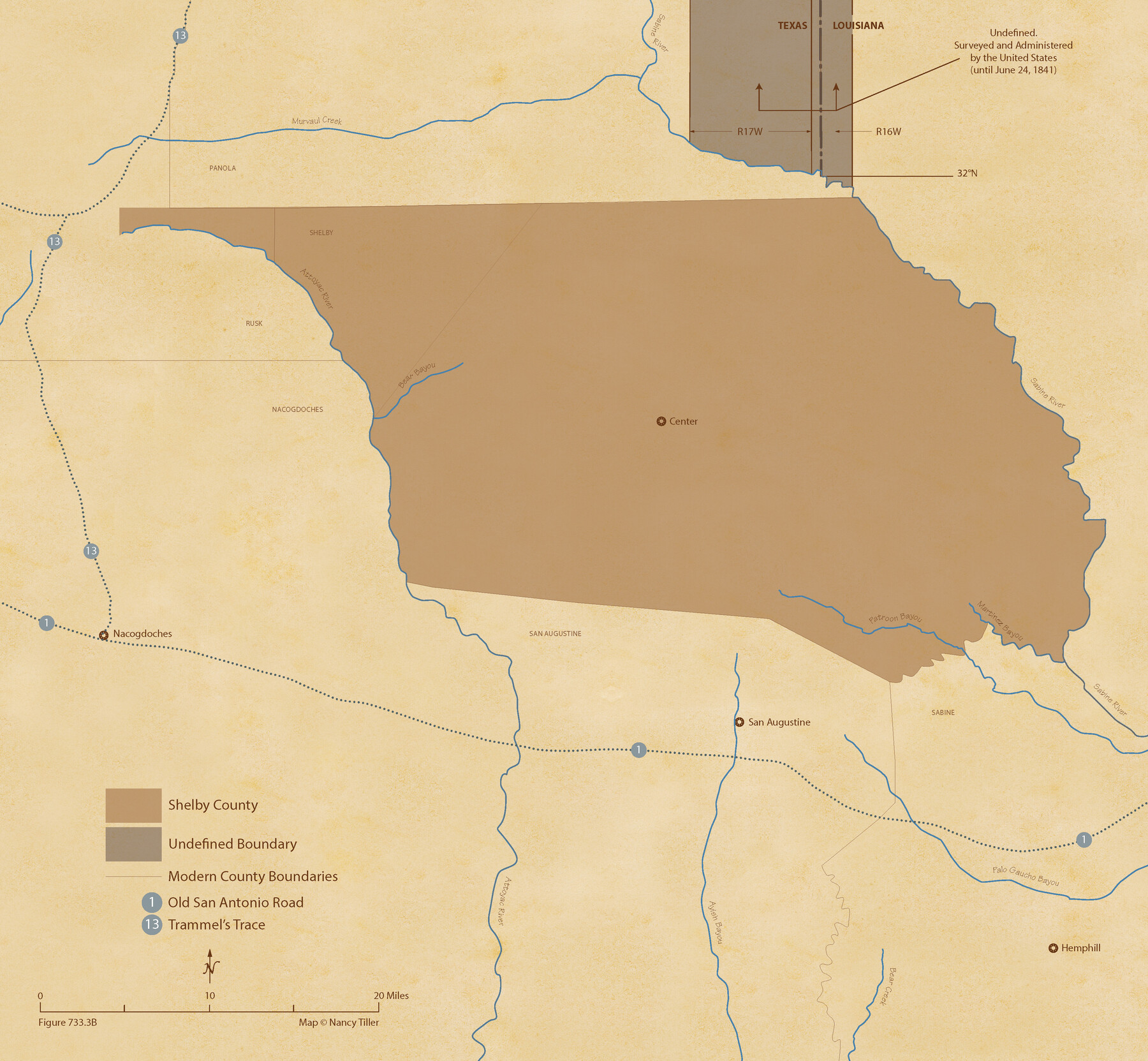
The Republic County of Shelby. January 30, 1841
Figure No. 733.3 from 'A Boundary Atlas of Texas, 1821-1845' by Jim Tiller
-
Map/Doc
96282
-
Collection
Nancy and Jim Tiller Digital Collection
-
Object Dates
2020/1/1 (Creation Date)
-
People and Organizations
Jim Tiller (Author)
Nancy Tiller (Cartographer)
Gang Gong (GIS Professional)
-
Counties
Shelby
-
Subjects
Atlas County Republic of Texas Texas Boundaries
-
Height x Width
20.0 x 21.7 inches
50.8 x 55.1 cm
-
Medium
digital image
-
Comments
To purchase a digital PDF copy of "A Boundary Atlas of Texas, 1821-1845" see 96437.
Part of: Nancy and Jim Tiller Digital Collection
The Nashville Association/Company Empresario Colony. October 15, 1827

Print $20.00
The Nashville Association/Company Empresario Colony. October 15, 1827
2020
Size 14.7 x 21.7 inches
Map/Doc 96001
The Republic County of Colorado. January 19, 1841

Print $20.00
The Republic County of Colorado. January 19, 1841
2020
Size 18.4 x 21.7 inches
Map/Doc 96124
The Judicial District/County of Panola. Abolished, Spring 1842

Print $20.00
The Judicial District/County of Panola. Abolished, Spring 1842
2020
Size 19.3 x 21.7 inches
Map/Doc 96342
The Republic County of Bowie. January 28, 1841

Print $20.00
The Republic County of Bowie. January 28, 1841
2020
Size 19.5 x 21.7 inches
Map/Doc 96103
From Citizens of Nacogdoches County Living East of the Trinity River and Along the Old San Antonio Road for the Creation of a New County (Unnamed), April 22, 1837

Print $20.00
From Citizens of Nacogdoches County Living East of the Trinity River and Along the Old San Antonio Road for the Creation of a New County (Unnamed), April 22, 1837
2020
Size 19.9 x 21.7 inches
Map/Doc 96374
The Republic County of Victoria. February 2, 1842

Print $20.00
The Republic County of Victoria. February 2, 1842
2020
Size 24.3 x 21.7 inches
Map/Doc 96299
The Republic County of Bastrop. Boundaries Defined, December 18, 1837

Print $20.00
The Republic County of Bastrop. Boundaries Defined, December 18, 1837
2020
Size 14.7 x 21.7 inches
Map/Doc 96089
Republic Counties. January 1, 1838

Print $20.00
Republic Counties. January 1, 1838
2020
Size 24.5 x 21.7 inches
Map/Doc 96311
The Republic County of Red River. Spring 1842

Print $20.00
The Republic County of Red River. Spring 1842
2020
Size 21.0 x 21.7 inches
Map/Doc 96254
The Chief Justice County of Brazoria. April 24, 1837

Print $20.00
The Chief Justice County of Brazoria. April 24, 1837
2020
Size 14.8 x 21.7 inches
Map/Doc 96042
The Chief Justice County of Harrisburg. Lands in Conflict with Brazoria, Liberty Counties

Print $20.00
The Chief Justice County of Harrisburg. Lands in Conflict with Brazoria, Liberty Counties
2020
Size 17.5 x 21.7 inches
Map/Doc 96050
The Republic County of Brazoria. Proposed, Late Fall 1837-January 1, 1838

Print $20.00
The Republic County of Brazoria. Proposed, Late Fall 1837-January 1, 1838
2020
Size 13.0 x 21.7 inches
Map/Doc 96110
You may also like
Grayson County Working Sketch 16

Print $20.00
- Digital $50.00
Grayson County Working Sketch 16
1954
Size 44.2 x 24.7 inches
Map/Doc 63255
Floyd County Working Sketch 2

Print $20.00
- Digital $50.00
Floyd County Working Sketch 2
1911
Size 41.0 x 24.8 inches
Map/Doc 69181
Jefferson County Rolled Sketch 37

Print $20.00
- Digital $50.00
Jefferson County Rolled Sketch 37
1957
Size 36.4 x 30.1 inches
Map/Doc 6396
Donley County Sketch File 30

Print $24.00
- Digital $50.00
Donley County Sketch File 30
1906
Size 11.3 x 8.7 inches
Map/Doc 21270
Rusk County Sketch File 31

Print $10.00
Rusk County Sketch File 31
1949
Size 11.3 x 8.9 inches
Map/Doc 35563
Liberty County Working Sketch 84

Print $20.00
- Digital $50.00
Liberty County Working Sketch 84
1981
Size 21.3 x 18.4 inches
Map/Doc 70544
[Block 1 and vicinity]
![90703, [Block 1 and vicinity], Twichell Survey Records](https://historictexasmaps.com/wmedia_w700/maps/90703-1.tif.jpg)
Print $20.00
- Digital $50.00
[Block 1 and vicinity]
Size 25.3 x 24.1 inches
Map/Doc 90703
Gillespie County Working Sketch 3

Print $20.00
- Digital $50.00
Gillespie County Working Sketch 3
1960
Size 23.0 x 21.7 inches
Map/Doc 63166
Flight Mission No. BQR-16K, Frame 37, Brazoria County

Print $20.00
- Digital $50.00
Flight Mission No. BQR-16K, Frame 37, Brazoria County
1952
Size 18.6 x 22.3 inches
Map/Doc 84104
Dimmit County Rolled Sketch 21

Print $20.00
- Digital $50.00
Dimmit County Rolled Sketch 21
2013
Size 25.5 x 22.5 inches
Map/Doc 93488
San Saba County Boundary File 1

Print $4.00
- Digital $50.00
San Saba County Boundary File 1
Size 14.2 x 8.7 inches
Map/Doc 58575
[Capitol Leagues 633, 634, 635, 636, and 637]
![90998, [Capitol Leagues 633, 634, 635, 636, and 637], Twichell Survey Records](https://historictexasmaps.com/wmedia_w700/maps/90998-1.tif.jpg)
Print $20.00
- Digital $50.00
[Capitol Leagues 633, 634, 635, 636, and 637]
Size 23.2 x 10.2 inches
Map/Doc 90998