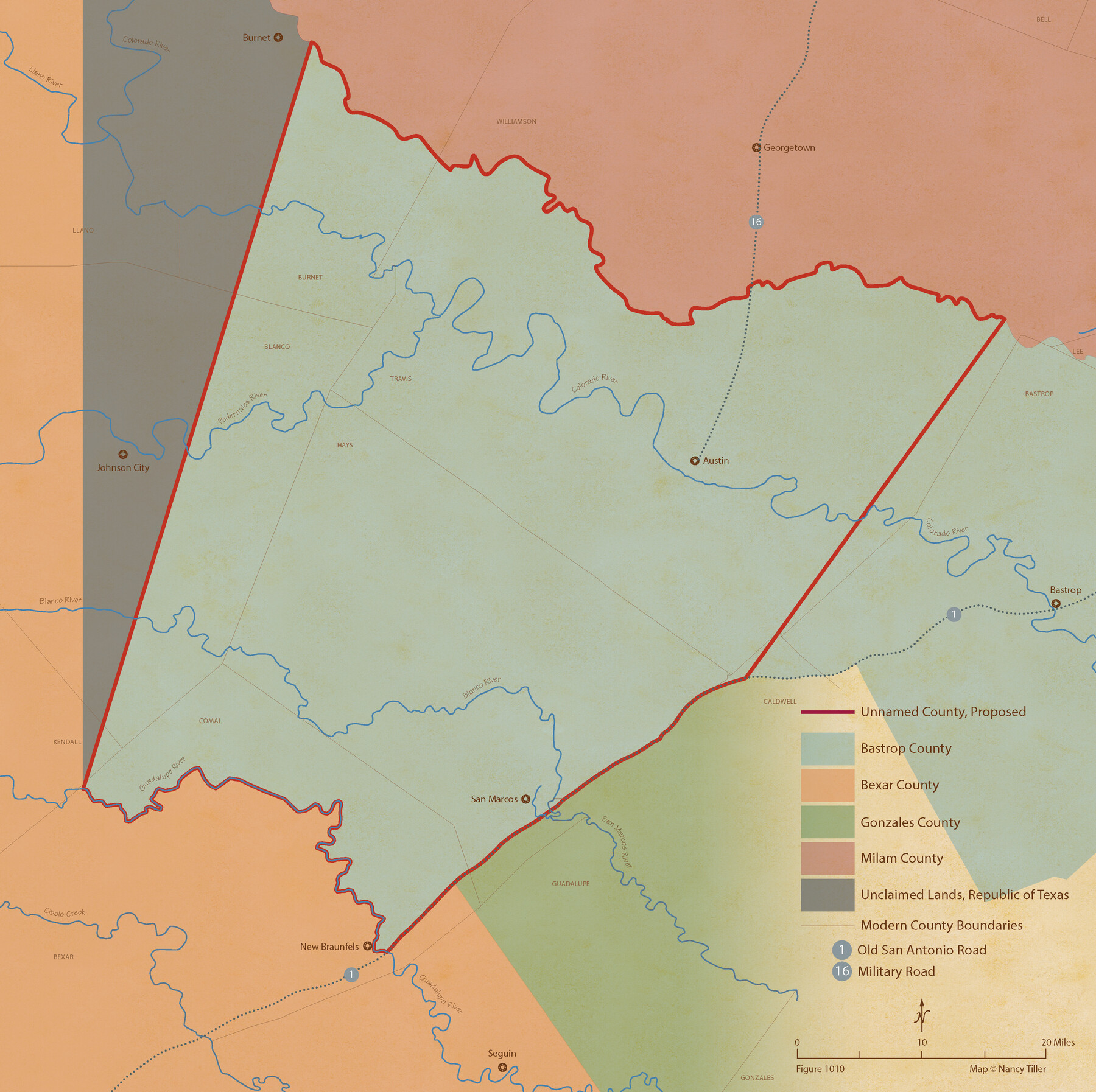
From Citizens of Bastrop County for the Creation of a New County (Unnamed), October 1838
Figure No. 1010 from 'A Boundary Atlas of Texas, 1821-1845' by Jim Tiller
-
Map/Doc
96384
-
Collection
Nancy and Jim Tiller Digital Collection
-
Object Dates
2020/1/1 (Creation Date)
-
People and Organizations
Jim Tiller (Author)
Nancy Tiller (Cartographer)
Gang Gong (GIS Professional)
-
Subjects
Atlas Republic of Texas Texas Boundaries
-
Height x Width
21.6 x 21.7 inches
54.9 x 55.1 cm
-
Medium
digital image
-
Comments
To purchase a digital PDF copy of "A Boundary Atlas of Texas, 1821-1845" see 96437.
Part of: Nancy and Jim Tiller Digital Collection
The Republic County of Jasper. January 29, 1842

Print $20.00
The Republic County of Jasper. January 29, 1842
2020
Size 19.5 x 21.7 inches
Map/Doc 96194
The Judicial District/County of Lavaca. Created, January 29, 1842

Print $20.00
The Judicial District/County of Lavaca. Created, January 29, 1842
2020
Size 14.6 x 21.7 inches
Map/Doc 96331
The Chief Justice County of San Patricio. Lands in Conflict with Bexar County

Print $20.00
The Chief Justice County of San Patricio. Lands in Conflict with Bexar County
2020
Size 20.0 x 21.7 inches
Map/Doc 96073
The Republic County of Nacogdoches. Spring 1842

Print $20.00
The Republic County of Nacogdoches. Spring 1842
2020
Size 15.9 x 21.8 inches
Map/Doc 96248
The Republic County of Bowie. Spring 1842

Print $20.00
The Republic County of Bowie. Spring 1842
2020
Size 19.5 x 21.7 inches
Map/Doc 96105
The Republic County of Victoria. Spring 1842

Print $20.00
The Republic County of Victoria. Spring 1842
2020
Size 24.3 x 21.7 inches
Map/Doc 96300
The Mexican Municipality of Brazoria. Created, April 28, 1832

Print $20.00
The Mexican Municipality of Brazoria. Created, April 28, 1832
2020
Size 16.5 x 21.7 inches
Map/Doc 96015
The Chief Justice County of Jackson. April 24, 1837

Print $20.00
The Chief Justice County of Jackson. April 24, 1837
2020
Size 18.4 x 21.7 inches
Map/Doc 96051
The Republic County of Goliad. Proposed, Late Fall 1837-December 31, 1838

Print $20.00
The Republic County of Goliad. Proposed, Late Fall 1837-December 31, 1838
2020
Size 15.1 x 21.7 inches
Map/Doc 96148
The Republic County of Matagorda. September 17, 1838

Print $20.00
The Republic County of Matagorda. September 17, 1838
2020
Size 21.0 x 21.7 inches
Map/Doc 96217
The Republic County of Gonzales. Spring 1842

Print $20.00
The Republic County of Gonzales. Spring 1842
2020
Size 14.7 x 21.7 inches
Map/Doc 96159
The Judicial District/County of DeWitt. Abolished, Spring 1842

Print $20.00
The Judicial District/County of DeWitt. Abolished, Spring 1842
2020
Size 22.4 x 21.7 inches
Map/Doc 96326
You may also like
Leon County Sketch File 25

Print $26.00
- Digital $50.00
Leon County Sketch File 25
Size 11.3 x 8.5 inches
Map/Doc 29788
Flight Mission No. CRK-3P, Frame 125, Refugio County

Print $20.00
- Digital $50.00
Flight Mission No. CRK-3P, Frame 125, Refugio County
1956
Size 18.5 x 22.5 inches
Map/Doc 86913
Hemphill County Working Sketch 21

Print $40.00
- Digital $50.00
Hemphill County Working Sketch 21
1973
Size 79.0 x 32.6 inches
Map/Doc 66116
[Surveys in Henderson County, Nacogdoches/Houston District]
![69735, [Surveys in Henderson County, Nacogdoches/Houston District], General Map Collection](https://historictexasmaps.com/wmedia_w700/maps/69735.tif.jpg)
Print $2.00
- Digital $50.00
[Surveys in Henderson County, Nacogdoches/Houston District]
Size 11.0 x 7.9 inches
Map/Doc 69735
King County Working Sketch 2

Print $20.00
- Digital $50.00
King County Working Sketch 2
1916
Size 13.6 x 13.9 inches
Map/Doc 70166
Map of the Western Part of Bexar District

Print $40.00
- Digital $50.00
Map of the Western Part of Bexar District
1849
Size 64.0 x 54.3 inches
Map/Doc 16944
Sketch of Lands in Oldham County, Texas

Print $2.00
- Digital $50.00
Sketch of Lands in Oldham County, Texas
Size 8.1 x 9.4 inches
Map/Doc 91441
Harris County Rolled Sketch 7b

Print $20.00
- Digital $50.00
Harris County Rolled Sketch 7b
Size 47.8 x 42.4 inches
Map/Doc 9853
Denison, Texas, Grayson County 1886

Print $20.00
Denison, Texas, Grayson County 1886
1886
Size 21.1 x 30.5 inches
Map/Doc 93466
Map of Bastrop District

Print $20.00
- Digital $50.00
Map of Bastrop District
1847
Size 22.9 x 28.3 inches
Map/Doc 3275
[Surveys in San Jacinto and Polk Counties]
![69749, [Surveys in San Jacinto and Polk Counties], General Map Collection](https://historictexasmaps.com/wmedia_w700/maps/69749.tif.jpg)
Print $2.00
- Digital $50.00
[Surveys in San Jacinto and Polk Counties]
Size 9.8 x 3.8 inches
Map/Doc 69749
Burleson County

Print $20.00
- Digital $50.00
Burleson County
1920
Size 40.6 x 45.7 inches
Map/Doc 4896