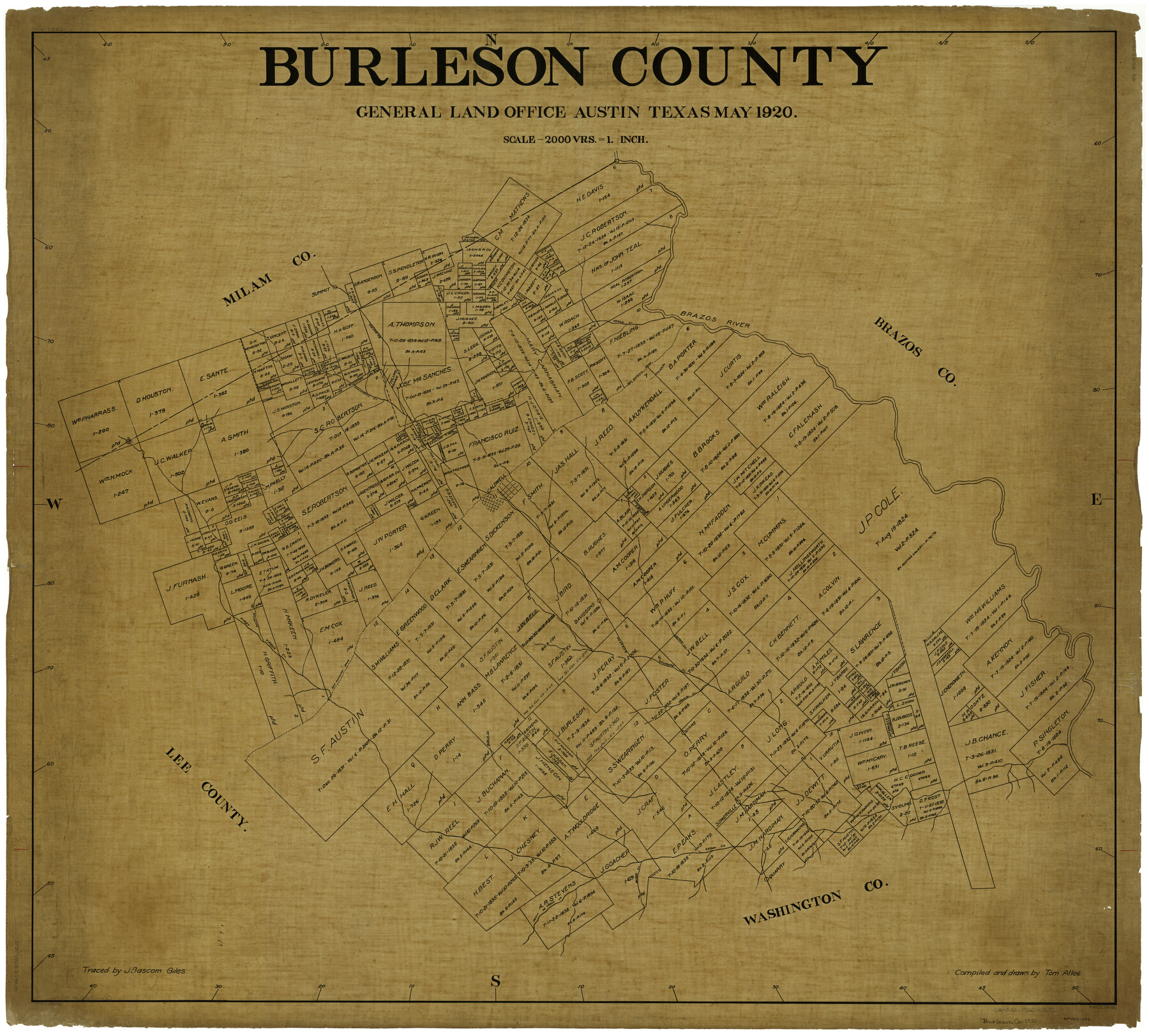
Burleson County
-
Map/Doc
4896
-
Collection
General Map Collection
-
Object Dates
5/1920 (Creation Date)
-
People and Organizations
Tom G. Atlee (Draftsman)
-
Counties
Burleson
-
Subjects
County
-
Height x Width
40.6 x 45.7 inches
103.1 x 116.1 cm
-
Comments
Traced by J. Bascom Giles.
Part of: General Map Collection
Gillespie County

Print $20.00
- Digital $50.00
Gillespie County
1945
Size 36.7 x 45.6 inches
Map/Doc 77289
[Surveys along the San Antonio Road near Caldwell]
![69760, [Surveys along the San Antonio Road near Caldwell], General Map Collection](https://historictexasmaps.com/wmedia_w700/maps/69760.tif.jpg)
Print $2.00
- Digital $50.00
[Surveys along the San Antonio Road near Caldwell]
1846
Size 9.2 x 7.7 inches
Map/Doc 69760
Nueces County NRC Article 33.136 Sketch 1

Print $274.00
- Digital $50.00
Nueces County NRC Article 33.136 Sketch 1
2002
Size 24.5 x 36.3 inches
Map/Doc 87920
Map of Smith County

Print $20.00
- Digital $50.00
Map of Smith County
1872
Size 20.0 x 20.6 inches
Map/Doc 4625
Randall County Working Sketch Graphic Index

Print $20.00
- Digital $50.00
Randall County Working Sketch Graphic Index
1958
Size 41.2 x 33.2 inches
Map/Doc 76676
Mosaic composed of aerial photographs - Galveston, Tex.

Print $20.00
- Digital $50.00
Mosaic composed of aerial photographs - Galveston, Tex.
1923
Size 15.3 x 33.3 inches
Map/Doc 97160
Freestone County Sketch File 24

Print $20.00
- Digital $50.00
Freestone County Sketch File 24
1951
Size 23.1 x 17.9 inches
Map/Doc 11517
Medina County Working Sketch 11

Print $20.00
- Digital $50.00
Medina County Working Sketch 11
1963
Size 21.8 x 26.5 inches
Map/Doc 70926
Lubbock County Boundary File 3

Print $2.00
- Digital $50.00
Lubbock County Boundary File 3
Size 11.3 x 8.8 inches
Map/Doc 56490
Kimble County Sketch File 10

Print $23.00
- Digital $50.00
Kimble County Sketch File 10
Size 18.5 x 15.6 inches
Map/Doc 28931
Fort Bend County State Real Property Sketch 17

Print $20.00
- Digital $50.00
Fort Bend County State Real Property Sketch 17
1985
Size 17.8 x 22.8 inches
Map/Doc 61665
Brewster County Sketch File NS-4e

Print $26.00
- Digital $50.00
Brewster County Sketch File NS-4e
1930
Size 8.7 x 11.2 inches
Map/Doc 15965
You may also like
Dawson County Working Sketch 17

Print $20.00
- Digital $50.00
Dawson County Working Sketch 17
1961
Size 33.3 x 29.9 inches
Map/Doc 68561
Flight Mission No. DAG-26K, Frame 58, Matagorda County

Print $20.00
- Digital $50.00
Flight Mission No. DAG-26K, Frame 58, Matagorda County
1953
Size 18.5 x 16.1 inches
Map/Doc 86578
Morris County Rolled Sketch 2A

Print $20.00
- Digital $50.00
Morris County Rolled Sketch 2A
Size 24.0 x 18.8 inches
Map/Doc 10238
Flight Mission No. BQR-20K, Frame 3, Brazoria County

Print $20.00
- Digital $50.00
Flight Mission No. BQR-20K, Frame 3, Brazoria County
1952
Size 18.6 x 22.2 inches
Map/Doc 84105
Under Sapphire Skies San Antonio

Under Sapphire Skies San Antonio
1928
Size 9.4 x 6.4 inches
Map/Doc 97043
Dimmit County Working Sketch 30

Print $20.00
- Digital $50.00
Dimmit County Working Sketch 30
1957
Size 22.2 x 26.0 inches
Map/Doc 68691
Irion County Sketch File 16

Print $8.00
- Digital $50.00
Irion County Sketch File 16
1952
Size 11.1 x 8.7 inches
Map/Doc 27490
Montgomery County Rolled Sketch 42

Print $20.00
- Digital $50.00
Montgomery County Rolled Sketch 42
1939
Size 14.1 x 20.1 inches
Map/Doc 6818
Flight Mission No. DCL-7C, Frame 42, Kenedy County

Print $20.00
- Digital $50.00
Flight Mission No. DCL-7C, Frame 42, Kenedy County
1943
Size 15.3 x 15.2 inches
Map/Doc 86030
Clay County Rolled Sketch 4

Print $20.00
- Digital $50.00
Clay County Rolled Sketch 4
1949
Size 32.2 x 25.6 inches
Map/Doc 5486
Trinity River, Red Bank Sheet

Print $20.00
- Digital $50.00
Trinity River, Red Bank Sheet
1925
Size 16.4 x 24.4 inches
Map/Doc 69687
Mitchell County Sketch File 7

Print $20.00
- Digital $50.00
Mitchell County Sketch File 7
1906
Size 19.4 x 12.4 inches
Map/Doc 12096