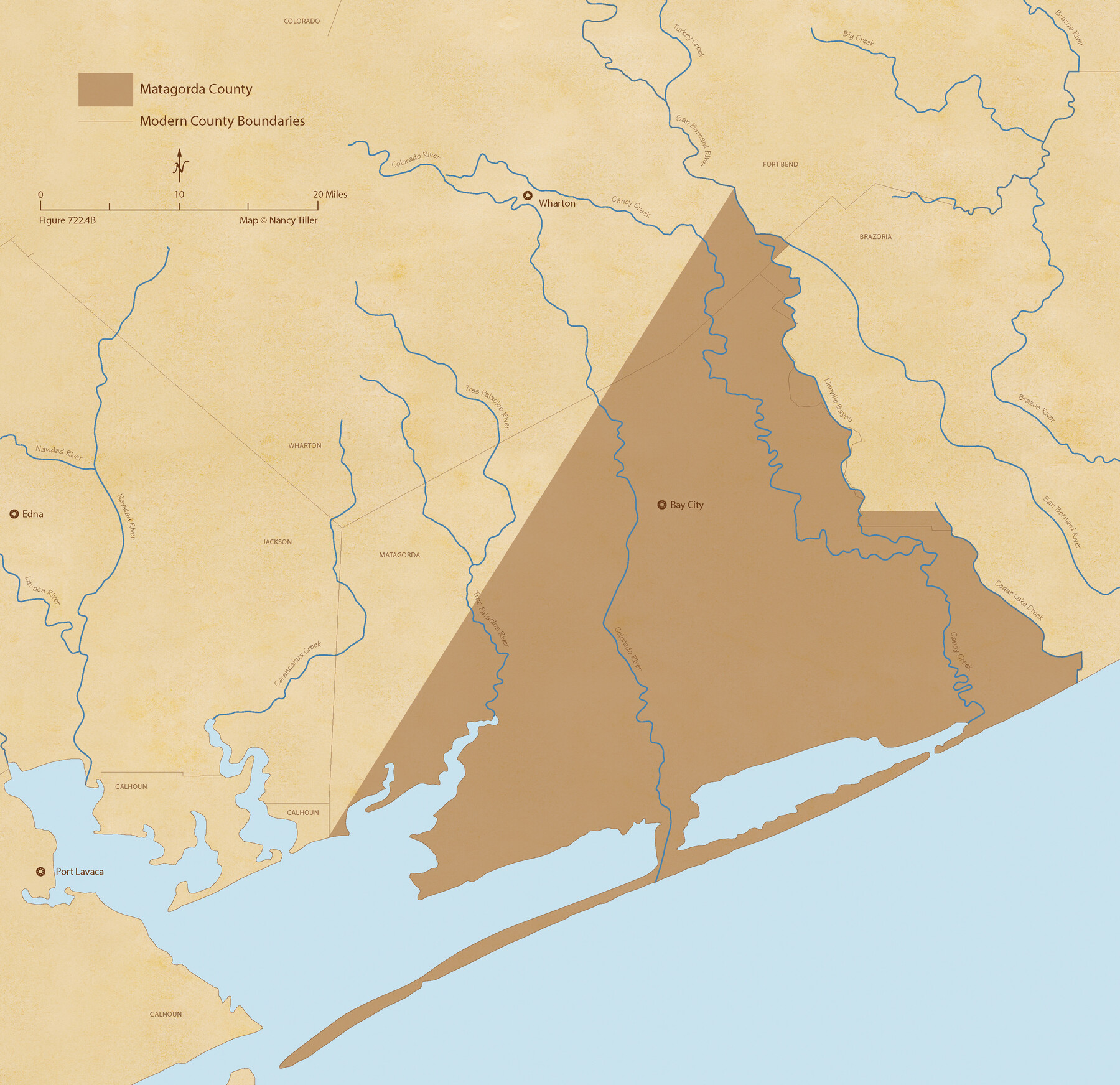
The Republic County of Matagorda. September 17, 1838
Figure No. 722.4 from 'A Boundary Atlas of Texas, 1821-1845' by Jim Tiller
-
Map/Doc
96217
-
Collection
Nancy and Jim Tiller Digital Collection
-
Object Dates
2020/1/1 (Creation Date)
-
People and Organizations
Jim Tiller (Author)
Nancy Tiller (Cartographer)
Gang Gong (GIS Professional)
-
Counties
Matagorda
-
Subjects
Atlas County Republic of Texas Texas Boundaries
-
Height x Width
21.0 x 21.7 inches
53.3 x 55.1 cm
-
Medium
digital image
-
Comments
To purchase a digital PDF copy of "A Boundary Atlas of Texas, 1821-1845" see 96437.
Part of: Nancy and Jim Tiller Digital Collection
The Republic County of Jasper. Boundaries Defined, December 14, 1837

Print $20.00
The Republic County of Jasper. Boundaries Defined, December 14, 1837
2020
Size 19.5 x 21.7 inches
Map/Doc 96193
The Chief Justice County of Brazoria. April 24, 1837

Print $20.00
The Chief Justice County of Brazoria. April 24, 1837
2020
Size 14.8 x 21.7 inches
Map/Doc 96042
The Republic County of Jackson. 1840

Print $20.00
The Republic County of Jackson. 1840
2020
Size 15.6 x 21.8 inches
Map/Doc 96186
Dominguez Empresario Colony. February 6, 1829

Print $20.00
Dominguez Empresario Colony. February 6, 1829
2020
Size 17.2 x 21.7 inches
Map/Doc 95992
The Republic County of Harris. Proposed, Late Fall 1837-May 15, 1838

Print $20.00
The Republic County of Harris. Proposed, Late Fall 1837-May 15, 1838
2020
Size 17.7 x 21.7 inches
Map/Doc 96162
The Republic County of Jefferson. January 20, 1841

Print $20.00
The Republic County of Jefferson. January 20, 1841
2020
Size 22.6 x 21.7 inches
Map/Doc 96198
The Judicial District/County of Burleson. Abolished, Spring 1842

Print $20.00
The Judicial District/County of Burleson. Abolished, Spring 1842
2020
Size 14.1 x 21.7 inches
Map/Doc 96321
The Mexican Department of Bexar. January 31, 1831

Print $20.00
The Mexican Department of Bexar. January 31, 1831
2020
Size 16.1 x 21.7 inches
Map/Doc 95968
The Judicial District/County of Ward. Created, January 19, 1841

Print $20.00
The Judicial District/County of Ward. Created, January 19, 1841
2020
Size 18.7 x 21.7 inches
Map/Doc 96354
The Chief Justice County of Victoria. Lands in Conflict with Bexar and Gonzales Counties

Print $20.00
The Chief Justice County of Victoria. Lands in Conflict with Bexar and Gonzales Counties
2020
Size 23.3 x 21.7 inches
Map/Doc 96076
The Republic County of Victoria. September 18, 1838

Print $20.00
The Republic County of Victoria. September 18, 1838
2020
Size 24.3 x 21.7 inches
Map/Doc 96296
Republic Counties. January 1, 1839

Print $20.00
Republic Counties. January 1, 1839
2020
Size 24.5 x 21.7 inches
Map/Doc 96312
You may also like
O'Neall Terrace, a Re-Subdivision of Blocks 37-38-39-40-43-44-45-46-110-112-113-114 and Parts of Blocks 111 and 115, McCrummens Second Addition to the City of Lubbock, Texas

Print $20.00
- Digital $50.00
O'Neall Terrace, a Re-Subdivision of Blocks 37-38-39-40-43-44-45-46-110-112-113-114 and Parts of Blocks 111 and 115, McCrummens Second Addition to the City of Lubbock, Texas
Size 22.6 x 27.5 inches
Map/Doc 92743
Terrell County Sketch File 21

Print $13.00
- Digital $50.00
Terrell County Sketch File 21
1911
Size 16.4 x 10.3 inches
Map/Doc 37948
Mills County Boundary File 3

Print $30.00
- Digital $50.00
Mills County Boundary File 3
Size 11.0 x 8.6 inches
Map/Doc 57281
Wilbarger County Working Sketch Graphic Index

Print $20.00
- Digital $50.00
Wilbarger County Working Sketch Graphic Index
1949
Size 46.7 x 38.0 inches
Map/Doc 76740
[Sketch of Col. Cooke's Military Road expedition from Red River to Austin]
![82272, [Sketch of Col. Cooke's Military Road expedition from Red River to Austin], General Map Collection](https://historictexasmaps.com/wmedia_w700/maps/82272-1.tif.jpg)
Print $40.00
- Digital $50.00
[Sketch of Col. Cooke's Military Road expedition from Red River to Austin]
Size 61.0 x 24.1 inches
Map/Doc 82272
Karnes County Working Sketch 15

Print $20.00
- Digital $50.00
Karnes County Working Sketch 15
1987
Size 36.0 x 41.1 inches
Map/Doc 66663
Flight Mission No. CLL-1N, Frame 11, Willacy County

Print $20.00
- Digital $50.00
Flight Mission No. CLL-1N, Frame 11, Willacy County
1954
Size 18.5 x 22.2 inches
Map/Doc 86998
University Land Field Notes for Blocks 1, 2, 8, 9, and 10 in Reagan County, Blocks 6 and 7 in Crockett and Reagan Counties, Blocks 3, 4, and 58 in Reagan and Upton Counties, and Block 5 in Crockett, Reagan, and Upton Counties

University Land Field Notes for Blocks 1, 2, 8, 9, and 10 in Reagan County, Blocks 6 and 7 in Crockett and Reagan Counties, Blocks 3, 4, and 58 in Reagan and Upton Counties, and Block 5 in Crockett, Reagan, and Upton Counties
Map/Doc 81716
Williamson County Sketch File 3

Print $24.00
- Digital $50.00
Williamson County Sketch File 3
1853
Size 13.0 x 8.2 inches
Map/Doc 40301
[Lynn and Adjacent Counties]
![92961, [Lynn and Adjacent Counties], Twichell Survey Records](https://historictexasmaps.com/wmedia_w700/maps/92961-1.tif.jpg)
Print $20.00
- Digital $50.00
[Lynn and Adjacent Counties]
Size 24.6 x 18.8 inches
Map/Doc 92961
North Half - Brown County, Texas

Print $40.00
- Digital $50.00
North Half - Brown County, Texas
1919
Size 42.2 x 64.8 inches
Map/Doc 97382
Coast of Texas from Vicinity of Bolivar Point to Rollover Station

Print $40.00
- Digital $50.00
Coast of Texas from Vicinity of Bolivar Point to Rollover Station
1886
Size 32.5 x 54.0 inches
Map/Doc 69920