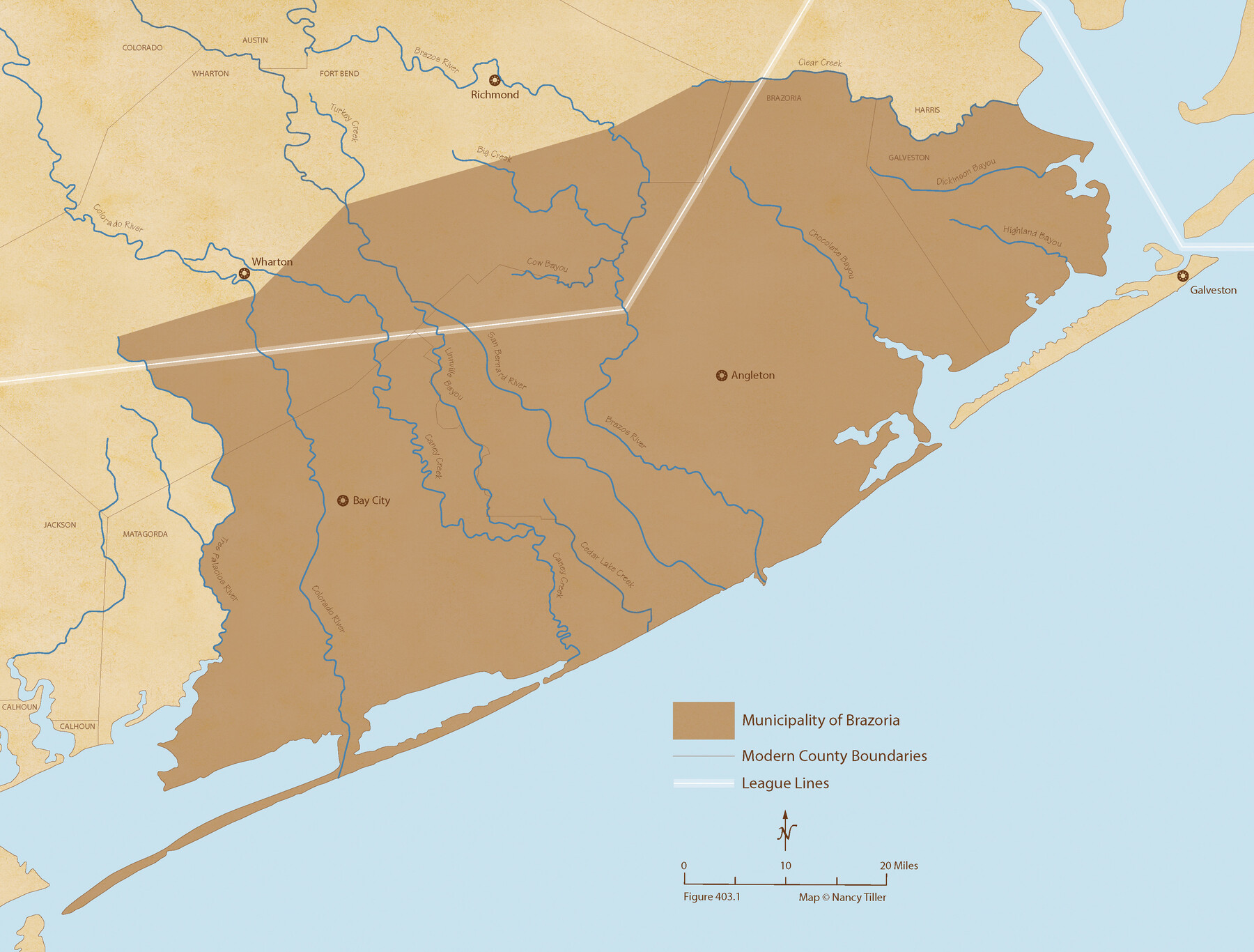
The Mexican Municipality of Brazoria. Created, April 28, 1832
Figure No. 403.1 from 'A Boundary Atlas of Texas, 1821-1845' by Jim Tiller
- 
                          Map/Doc
96015
 - 
                            Collection
Nancy and Jim Tiller Digital Collection
 - 
                            Object Dates
2020/1/1 (Creation Date)
 - 
                            People and Organizations
Jim Tiller (Author)
Nancy Tiller (Cartographer)
Gang Gong (GIS Professional)
 - 
                            Subjects
Atlas Mexican Texas Texas Boundaries
 - 
                            Height x Width
16.5 x 21.7 inches
41.9 x 55.1 cm
 - 
                            Medium
digital image
 - 
                            Comments
To purchase a digital PDF copy of "A Boundary Atlas of Texas, 1821-1845" see 96437.
 
Part of: Nancy and Jim Tiller Digital Collection
            The Chief Justice County of Mina. Lands in Conflict with Colorado County


                                            Print $20.00                    
                                    
                The Chief Justice County of Mina. Lands in Conflict with Colorado County
2020
Size 15.8 x 21.7 inches
                                Map/Doc 96062
            
            The Mexican Municipality of Brazoria. December 28, 1834


                                            Print $20.00                    
                                    
                The Mexican Municipality of Brazoria. December 28, 1834
2020
Size 16.5 x 21.7 inches
                                Map/Doc 96017
            
            Austin Empresario Colony. February 25, 1831


                                            Print $20.00                    
                                    
                Austin Empresario Colony. February 25, 1831
2020
Size 17.0 x 21.7 inches
                                Map/Doc 95983
            
            Vehlein and Company Empresario Colony. November 17, 1828


                                            Print $20.00                    
                                    
                Vehlein and Company Empresario Colony. November 17, 1828
2020
Size 20.8 x 21.7 inches
                                Map/Doc 96008
            
            The Judicial District/County of Panola. June 24, 1841


                                            Print $20.00                    
                                    
                The Judicial District/County of Panola. June 24, 1841
2020
Size 19.3 x 21.7 inches
                                Map/Doc 96341
            
            The Republic County of Bastrop. Boundaries Defined, December 18, 1837


                                            Print $20.00                    
                                    
                The Republic County of Bastrop. Boundaries Defined, December 18, 1837
2020
Size 14.7 x 21.7 inches
                                Map/Doc 96089
            
            The Republic County of Houston. February 2, 1842


                                            Print $20.00                    
                                    
                The Republic County of Houston. February 2, 1842
2020
Size 19.7 x 21.8 inches
                                Map/Doc 96181
            
            The Republic County of Montgomery. January 21, 1841


                                            Print $20.00                    
                                    
                The Republic County of Montgomery. January 21, 1841
2020
Size 19.9 x 21.7 inches
                                Map/Doc 96238
            
            The Republic County of Jefferson. December 29, 1845


                                            Print $20.00                    
                                    
                The Republic County of Jefferson. December 29, 1845
2020
Size 22.6 x 21.7 inches
                                Map/Doc 96201
            
            The Republic County of Montgomery. Spring 1842


                                            Print $20.00                    
                                    
                The Republic County of Montgomery. Spring 1842
2020
Size 19.9 x 21.7 inches
                                Map/Doc 96240
            
            The Land Offices. No. 6, Washington, December 22, 1836


                                            Print $20.00                    
                                    
                The Land Offices. No. 6, Washington, December 22, 1836
2020
Size 16.5 x 21.7 inches
                                Map/Doc 96419
            
            The Republic County of Colorado. January 29, 1842


                                            Print $20.00                    
                                    
                The Republic County of Colorado. January 29, 1842
2020
Size 18.4 x 21.7 inches
                                Map/Doc 96125
            You may also like
            Newton County Sketch File 23


                                            Print $4.00                    
                                             -                         Digital $50.00                                    
                Newton County Sketch File 23
1855
Size 10.1 x 8.0 inches
                                Map/Doc 32403
            
            Fannin County Boundary File 8


                                            Print $8.00                    
                                             -                         Digital $50.00                                    
                Fannin County Boundary File 8
Size 12.8 x 8.1 inches
                                Map/Doc 53316
            
            Harbor Pass and Bar at Brazos Santiago, Texas


                                            Print $20.00                    
                                             -                         Digital $50.00                                    
                Harbor Pass and Bar at Brazos Santiago, Texas
1879
Size 18.1 x 27.4 inches
                                Map/Doc 73002
            
            Kimble County Working Sketch 96


                                            Print $20.00                    
                                             -                         Digital $50.00                                    
                Kimble County Working Sketch 96
1921
Size 20.9 x 26.8 inches
                                Map/Doc 70164
            
            Panola County Sketch File 16


                                            Print $4.00                    
                                             -                         Digital $50.00                                    
                Panola County Sketch File 16
1882
Size 6.4 x 8.8 inches
                                Map/Doc 33476
            
            Walker County


                                            Print $20.00                    
                                             -                         Digital $50.00                                    
                Walker County
1944
Size 45.7 x 38.4 inches
                                Map/Doc 73314
            
            Navarro County


                                            Print $40.00                    
                                             -                         Digital $50.00                                    
                Navarro County
1924
Size 41.5 x 47.9 inches
                                Map/Doc 73249
            
            Hemphill County Working Sketch 8


                                            Print $40.00                    
                                             -                         Digital $50.00                                    
                Hemphill County Working Sketch 8
1965
Size 25.8 x 64.6 inches
                                Map/Doc 66103
            
            Robertson & Scott V Ranch situated in Crosby County, Texas


                                            Print $40.00                    
                                             -                         Digital $50.00                                    
                Robertson & Scott V Ranch situated in Crosby County, Texas
Size 42.0 x 50.3 inches
                                Map/Doc 89753
            
            Ward County Rolled Sketch 14


                                            Print $20.00                    
                                             -                         Digital $50.00                                    
                Ward County Rolled Sketch 14
1940
Size 18.5 x 26.2 inches
                                Map/Doc 8157
            
            Steele Addition, Seagraves, Texas


                                            Print $20.00                    
                                             -                         Digital $50.00                                    
                Steele Addition, Seagraves, Texas
Size 17.4 x 26.3 inches
                                Map/Doc 92655