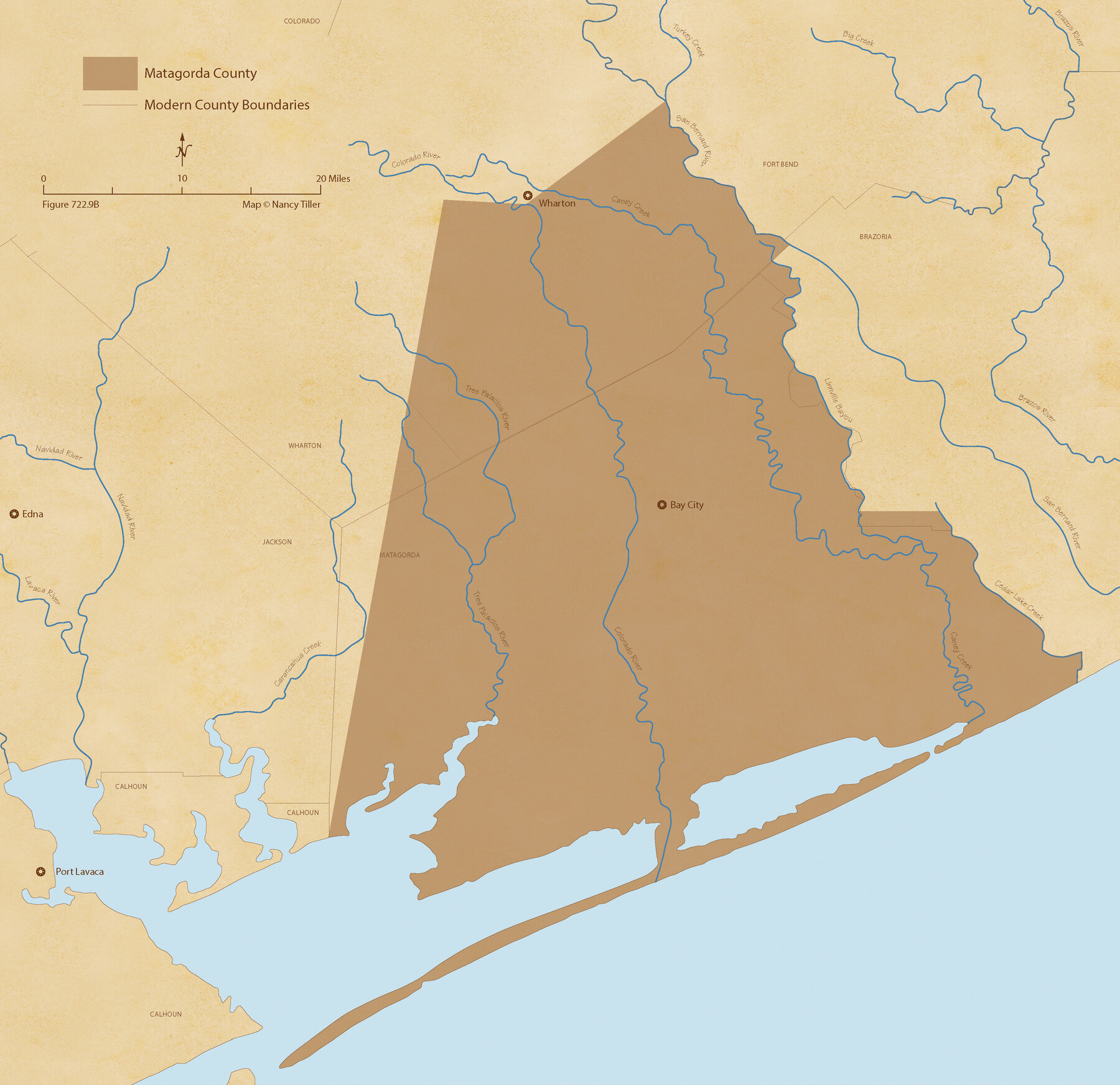
The Republic County of Matagorda. Spring 1842
Figure No. 722.9 from 'A Boundary Atlas of Texas, 1821-1845' by Jim Tiller
-
Map/Doc
96222
-
Collection
Nancy and Jim Tiller Digital Collection
-
Object Dates
2020/1/1 (Creation Date)
-
People and Organizations
Jim Tiller (Author)
Nancy Tiller (Cartographer)
Gang Gong (GIS Professional)
-
Counties
Matagorda
-
Subjects
Atlas County Republic of Texas Texas Boundaries
-
Height x Width
21.0 x 21.7 inches
53.3 x 55.1 cm
-
Medium
digital image
-
Comments
To purchase a digital PDF copy of "A Boundary Atlas of Texas, 1821-1845" see 96437.
Part of: Nancy and Jim Tiller Digital Collection
The Republic County of Galveston. January 20, 1841

Print $20.00
The Republic County of Galveston. January 20, 1841
2020
Size 14.7 x 21.9 inches
Map/Doc 96145
The Republic County of Refugio. December 2, 1841

Print $20.00
The Republic County of Refugio. December 2, 1841
2020
Size 22.3 x 21.6 inches
Map/Doc 96257
The Republic County of Victoria. Proposed, Late Fall 1837

Print $20.00
The Republic County of Victoria. Proposed, Late Fall 1837
2020
Size 22.5 x 21.7 inches
Map/Doc 96294
The Republic County of Colorado. 1840

Print $20.00
The Republic County of Colorado. 1840
2020
Size 18.4 x 21.7 inches
Map/Doc 96122
The Judicial District/County of Spring Creek. Abolished, Spring 1842

Print $20.00
The Judicial District/County of Spring Creek. Abolished, Spring 1842
2020
Size 15.7 x 21.7 inches
Map/Doc 96349
The Republic County of Brazoria. Proposed, Late Fall 1837

Print $20.00
The Republic County of Brazoria. Proposed, Late Fall 1837
2020
Size 13.0 x 21.7 inches
Map/Doc 96109
The Republic County of Red River. December 29, 1845

Print $20.00
The Republic County of Red River. December 29, 1845
2020
Size 21.0 x 21.7 inches
Map/Doc 96255
The Republic County of Gonzales. Boundaries Defined, December 14, 1837

Print $20.00
The Republic County of Gonzales. Boundaries Defined, December 14, 1837
2020
Size 14.7 x 21.7 inches
Map/Doc 96153
The Republic County of Matagorda. Spring 1842

Print $20.00
The Republic County of Matagorda. Spring 1842
2020
Size 21.0 x 21.7 inches
Map/Doc 96222
de Leon Empresario Colony. Absorbed by DeWitt Colony. April 15, 1825

Print $20.00
de Leon Empresario Colony. Absorbed by DeWitt Colony. April 15, 1825
2020
Size 18.5 x 21.7 inches
Map/Doc 95989
The Republic County of Fort Bend. February 5, 1840

Print $20.00
The Republic County of Fort Bend. February 5, 1840
2020
Size 14.7 x 21.6 inches
Map/Doc 96139
The Republic County of Jasper. December 29, 1845

Print $20.00
The Republic County of Jasper. December 29, 1845
2020
Size 19.5 x 21.7 inches
Map/Doc 96196
You may also like
Flight Mission No. DIX-10P, Frame 148, Aransas County

Print $20.00
- Digital $50.00
Flight Mission No. DIX-10P, Frame 148, Aransas County
1956
Size 18.6 x 22.3 inches
Map/Doc 83950
Maps of Gulf Intracoastal Waterway, Texas - Sabine River to the Rio Grande and connecting waterways including ship channels

Print $20.00
- Digital $50.00
Maps of Gulf Intracoastal Waterway, Texas - Sabine River to the Rio Grande and connecting waterways including ship channels
1966
Size 14.6 x 22.3 inches
Map/Doc 61930
Webb County Sketch File 54

Print $46.00
- Digital $50.00
Webb County Sketch File 54
1939
Size 11.3 x 8.8 inches
Map/Doc 39841
Flight Mission No. BRA-16M, Frame 101, Jefferson County

Print $20.00
- Digital $50.00
Flight Mission No. BRA-16M, Frame 101, Jefferson County
1953
Size 18.6 x 22.4 inches
Map/Doc 85713
Jack County Boundary File 3

Print $10.00
- Digital $50.00
Jack County Boundary File 3
Size 9.2 x 4.0 inches
Map/Doc 55408
Kent County Working Sketch 17

Print $20.00
- Digital $50.00
Kent County Working Sketch 17
1973
Size 34.8 x 36.4 inches
Map/Doc 70024
General Highway Map, Ector County, Texas

Print $20.00
General Highway Map, Ector County, Texas
1940
Size 18.4 x 24.9 inches
Map/Doc 79081
El Paso County Working Sketch 21

Print $20.00
- Digital $50.00
El Paso County Working Sketch 21
1960
Size 37.8 x 30.9 inches
Map/Doc 69043
Fort Bend County State Real Property Sketch 3

Print $40.00
- Digital $50.00
Fort Bend County State Real Property Sketch 3
1986
Size 34.5 x 43.6 inches
Map/Doc 61677
Flight Mission No. DCL-6C, Frame 97, Kenedy County

Print $20.00
- Digital $50.00
Flight Mission No. DCL-6C, Frame 97, Kenedy County
1943
Size 18.6 x 22.3 inches
Map/Doc 85927
Leon County Working Sketch 32

Print $20.00
- Digital $50.00
Leon County Working Sketch 32
1975
Size 38.2 x 28.8 inches
Map/Doc 70431
Coke County Working Sketch 9

Print $20.00
- Digital $50.00
Coke County Working Sketch 9
1927
Size 23.9 x 30.3 inches
Map/Doc 68046