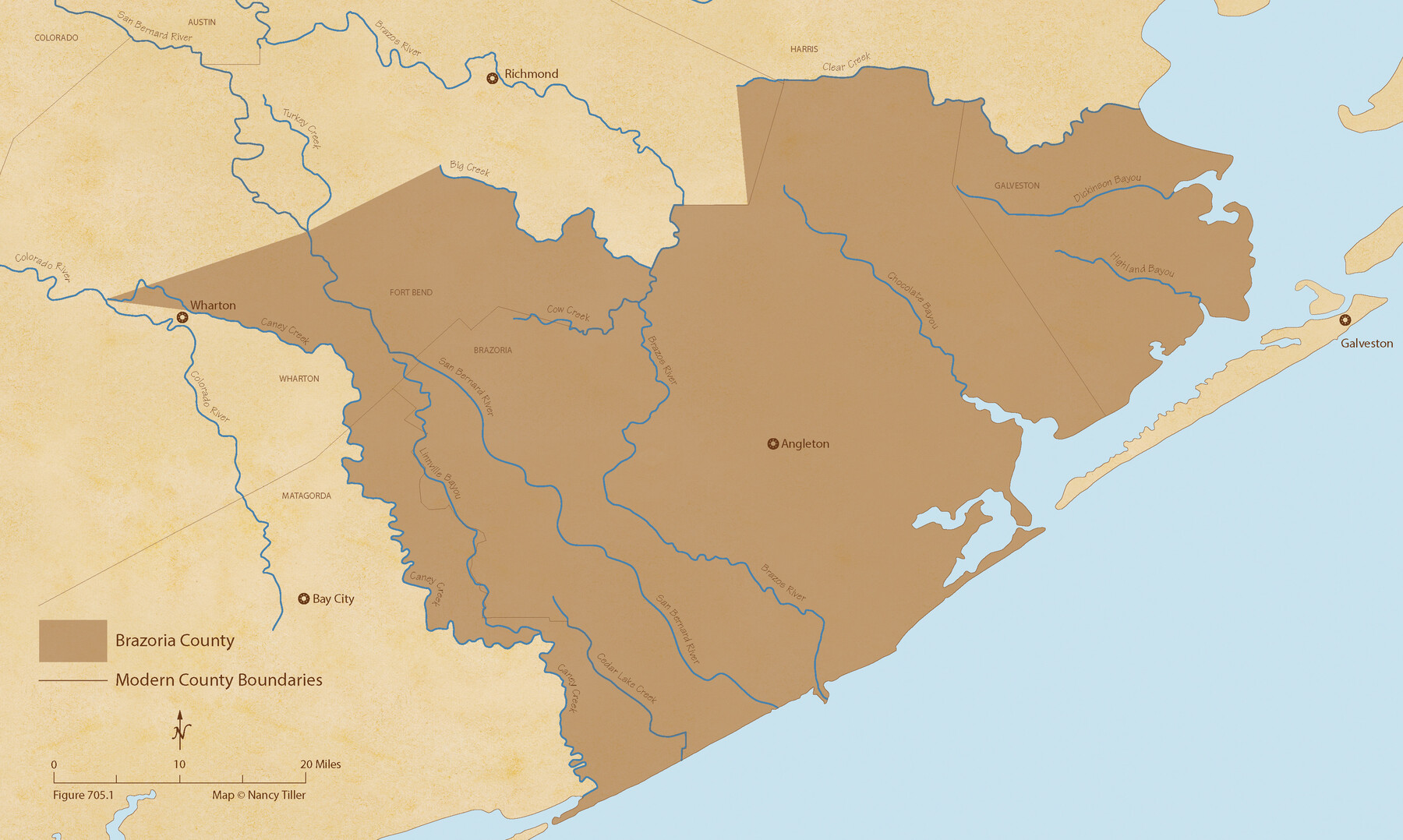
The Republic County of Brazoria. Proposed, Late Fall 1837
Figure No. 705.1 from 'A Boundary Atlas of Texas, 1821-1845' by Jim Tiller
-
Map/Doc
96109
-
Collection
Nancy and Jim Tiller Digital Collection
-
Object Dates
2020/1/1 (Creation Date)
-
People and Organizations
Jim Tiller (Author)
Nancy Tiller (Cartographer)
Gang Gong (GIS Professional)
-
Counties
Brazoria
-
Subjects
Atlas County Republic of Texas Texas Boundaries
-
Height x Width
13.0 x 21.7 inches
33.0 x 55.1 cm
-
Medium
digital image
-
Comments
To purchase a digital PDF copy of "A Boundary Atlas of Texas, 1821-1845" see 96437.
Part of: Nancy and Jim Tiller Digital Collection
The Republic County of Bexar. South View. Proposed, Fall 1837-December 31, 1838

Print $20.00
The Republic County of Bexar. South View. Proposed, Fall 1837-December 31, 1838
2020
Size 14.7 x 22.3 inches
Map/Doc 96095
The Republic County of Bastrop. May 24, 1838

Print $20.00
The Republic County of Bastrop. May 24, 1838
2020
Size 17.8 x 21.7 inches
Map/Doc 96090
The Republic County of Lamar. January 28, 1841

Print $20.00
The Republic County of Lamar. January 28, 1841
2020
Size 16.4 x 21.7 inches
Map/Doc 96203
The Republic County of Milam. December 31, 1838

Print $20.00
The Republic County of Milam. December 31, 1838
2020
Size 17.4 x 21.6 inches
Map/Doc 96227
The Republic County of Shelby. December 14, 1837

Print $20.00
The Republic County of Shelby. December 14, 1837
2020
Size 21.1 x 21.7 inches
Map/Doc 96279
The Judicial District/County of Guadalupe. Created, January 29, 1842

Print $20.00
The Judicial District/County of Guadalupe. Created, January 29, 1842
2020
Size 16.7 x 21.7 inches
Map/Doc 96327
The Republic County of San Patricio. December 29, 1845

Print $20.00
The Republic County of San Patricio. December 29, 1845
2020
Size 22.2 x 21.7 inches
Map/Doc 96278
The Republic County of Gonzales. February 2, 1842

Print $20.00
The Republic County of Gonzales. February 2, 1842
2020
Size 14.7 x 21.7 inches
Map/Doc 96158
The Republic County of Travis. Spring 1842

Print $20.00
The Republic County of Travis. Spring 1842
2020
Size 20.8 x 21.6 inches
Map/Doc 96292
The Chief Justice County of Milam. April 16, 1837

Print $20.00
The Chief Justice County of Milam. April 16, 1837
2020
Size 16.8 x 21.7 inches
Map/Doc 96059
The Republic County of Refugio. Proposed, Late Fall 1837

Print $20.00
The Republic County of Refugio. Proposed, Late Fall 1837
2020
Size 22.3 x 21.6 inches
Map/Doc 96256
The Republic County of Victoria. Boundaries Refined, January 25, 1841

Print $20.00
The Republic County of Victoria. Boundaries Refined, January 25, 1841
2020
Size 19.3 x 21.8 inches
Map/Doc 96297
You may also like
Travis County Rolled Sketch 38

Print $20.00
- Digital $50.00
Travis County Rolled Sketch 38
Size 31.9 x 30.3 inches
Map/Doc 8038
Travis County Sketch File 13

Print $4.00
- Digital $50.00
Travis County Sketch File 13
1858
Size 8.2 x 6.5 inches
Map/Doc 38306
Zapata County Working Sketch 9

Print $20.00
- Digital $50.00
Zapata County Working Sketch 9
1951
Size 34.9 x 18.1 inches
Map/Doc 62060
Taylor County Rolled Sketch 25

Print $20.00
- Digital $50.00
Taylor County Rolled Sketch 25
1962
Size 27.1 x 46.0 inches
Map/Doc 7917
Flight Mission No. CLL-1N, Frame 84, Willacy County

Print $20.00
- Digital $50.00
Flight Mission No. CLL-1N, Frame 84, Willacy County
1954
Size 18.5 x 22.2 inches
Map/Doc 87030
Wichita County Rolled Sketch 14

Print $20.00
- Digital $50.00
Wichita County Rolled Sketch 14
1927
Size 36.7 x 30.5 inches
Map/Doc 8251

Hardeman County Sketch File 16

Print $20.00
- Digital $50.00
Hardeman County Sketch File 16
Size 21.9 x 26.8 inches
Map/Doc 11628
Intracoastal Waterway in Texas - Corpus Christi to Point Isabel including Arroyo Colorado to Mo. Pac. R.R. Bridge Near Harlingen

Print $20.00
- Digital $50.00
Intracoastal Waterway in Texas - Corpus Christi to Point Isabel including Arroyo Colorado to Mo. Pac. R.R. Bridge Near Harlingen
1933
Size 28.2 x 41.0 inches
Map/Doc 61846
Comanche County Sketch File 22

Print $4.00
- Digital $50.00
Comanche County Sketch File 22
1873
Size 15.2 x 9.2 inches
Map/Doc 19106
Parker County Sketch File 1

Print $4.00
- Digital $50.00
Parker County Sketch File 1
Size 8.5 x 10.4 inches
Map/Doc 33516
Brewster County Working Sketch 101

Print $40.00
- Digital $50.00
Brewster County Working Sketch 101
1980
Size 60.2 x 43.2 inches
Map/Doc 67701