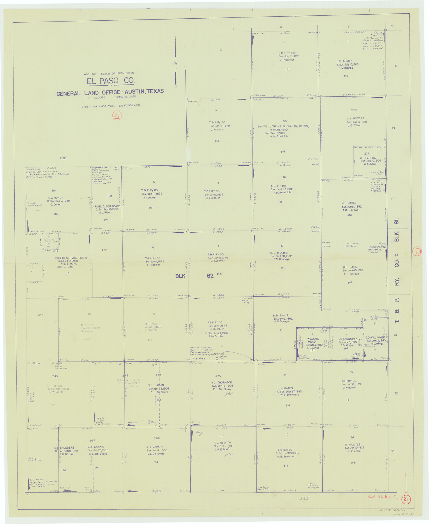
El Paso County Working Sketch 21
- 
                          Map/Doc
69043
 - 
                            Collection
General Map Collection
 - 
                            Object Dates
7/27/1960 (Creation Date)
 - 
                            Counties
El Paso
 - 
                            Subjects
Surveying Working Sketch
 - 
                            Height x Width
37.8 x 30.9 inches
96.0 x 78.5 cm
 - 
                            Scale
1" = 400 varas
 
Part of: General Map Collection
            Map of surveys made for the Texas & Pacific Railway Co. in Andrews & Tom Green Cos. Blocks 42, 43, 44, 45 & 46 reserve west of the Colorado River


                                            Print $20.00                    
                                             -                         Digital $50.00                                    
                Map of surveys made for the Texas & Pacific Railway Co. in Andrews & Tom Green Cos. Blocks 42, 43, 44, 45 & 46 reserve west of the Colorado River
1876
Size 42.3 x 37.6 inches
                                Map/Doc 2225
            
            Van Zandt County Working Sketch 19


                                            Print $20.00                    
                                             -                         Digital $50.00                                    
                Van Zandt County Working Sketch 19
Size 43.3 x 32.8 inches
                                Map/Doc 72269
            
            Johnson County Rolled Sketch 4


                                            Print $20.00                    
                                             -                         Digital $50.00                                    
                Johnson County Rolled Sketch 4
Size 24.8 x 36.0 inches
                                Map/Doc 94047
            
            Presidio County Sketch File 94


                                            Print $6.00                    
                                             -                         Digital $50.00                                    
                Presidio County Sketch File 94
1955
Size 14.2 x 8.8 inches
                                Map/Doc 34770
            
            La Salle County Rolled Sketch 4


                                            Print $20.00                    
                                             -                         Digital $50.00                                    
                La Salle County Rolled Sketch 4
1937
Size 20.9 x 27.5 inches
                                Map/Doc 6569
            
            Foard County Working Sketch 13


                                            Print $40.00                    
                                             -                         Digital $50.00                                    
                Foard County Working Sketch 13
1981
Size 44.0 x 51.2 inches
                                Map/Doc 69204
            
            Val Verde County Working Sketch 26


                                            Print $20.00                    
                                             -                         Digital $50.00                                    
                Val Verde County Working Sketch 26
1936
Size 22.9 x 31.5 inches
                                Map/Doc 72161
            
            Map of Houston Heights, Harris County, Texas owned by the Omaha & South Texas Land Co., Houston, Texas


                                            Print $20.00                    
                                             -                         Digital $50.00                                    
                Map of Houston Heights, Harris County, Texas owned by the Omaha & South Texas Land Co., Houston, Texas
1891
Size 16.3 x 10.7 inches
                                Map/Doc 94458
            
            Kerr County Rolled Sketch 11


                                            Print $20.00                    
                                             -                         Digital $50.00                                    
                Kerr County Rolled Sketch 11
1950
Size 28.1 x 36.9 inches
                                Map/Doc 6495
            
            Foard County Rolled Sketch 14 1/2


                                            Print $20.00                    
                                             -                         Digital $50.00                                    
                Foard County Rolled Sketch 14 1/2
1888
Size 20.8 x 37.4 inches
                                Map/Doc 5889
            
            Lampasas County Boundary File 11


                                            Print $4.00                    
                                             -                         Digital $50.00                                    
                Lampasas County Boundary File 11
Size 14.0 x 8.6 inches
                                Map/Doc 56189
            You may also like
            Culberson County Working Sketch 58


                                            Print $20.00                    
                                             -                         Digital $50.00                                    
                Culberson County Working Sketch 58
1974
Size 45.2 x 35.1 inches
                                Map/Doc 68512
            
            Flight Mission No. BQR-20K, Frame 6, Brazoria County


                                            Print $20.00                    
                                             -                         Digital $50.00                                    
                Flight Mission No. BQR-20K, Frame 6, Brazoria County
1952
Size 18.6 x 22.3 inches
                                Map/Doc 84108
            
            Liberty County Working Sketch 16


                                            Print $20.00                    
                                             -                         Digital $50.00                                    
                Liberty County Working Sketch 16
1936
Size 24.1 x 34.7 inches
                                Map/Doc 70475
            
            South Part Brewster Co.


                                            Print $40.00                    
                                             -                         Digital $50.00                                    
                South Part Brewster Co.
Size 36.5 x 51.5 inches
                                Map/Doc 66723
            
            Medina County Working Sketch 21


                                            Print $4.00                    
                                             -                         Digital $50.00                                    
                Medina County Working Sketch 21
1982
Size 18.1 x 23.3 inches
                                Map/Doc 70936
            
            Flight Mission No. DIX-10P, Frame 145, Aransas County


                                            Print $20.00                    
                                             -                         Digital $50.00                                    
                Flight Mission No. DIX-10P, Frame 145, Aransas County
1956
Size 18.7 x 22.3 inches
                                Map/Doc 83947
            
            Knox County Working Sketch 17


                                            Print $20.00                    
                                             -                         Digital $50.00                                    
                Knox County Working Sketch 17
1967
Size 36.8 x 27.1 inches
                                Map/Doc 70259
            
            El Paso County Working Sketch 47


                                            Print $20.00                    
                                             -                         Digital $50.00                                    
                El Paso County Working Sketch 47
Size 28.3 x 30.5 inches
                                Map/Doc 69069
            
            Crosby County Sketch File 23


                                            Print $20.00                    
                                             -                         Digital $50.00                                    
                Crosby County Sketch File 23
1913
Size 15.0 x 27.2 inches
                                Map/Doc 11254
            
            Montgomery County Rolled Sketch 10


                                            Print $20.00                    
                                             -                         Digital $50.00                                    
                Montgomery County Rolled Sketch 10
1905
Size 35.5 x 26.2 inches
                                Map/Doc 6796
            
            Pecos County Boundary File 2


                                            Print $38.00                    
                                             -                         Digital $50.00                                    
                Pecos County Boundary File 2
Size 11.2 x 8.7 inches
                                Map/Doc 57871
            
            La Salle County Working Sketch 29


                                            Print $20.00                    
                                             -                         Digital $50.00                                    
                La Salle County Working Sketch 29
1955
Size 25.8 x 27.4 inches
                                Map/Doc 70330