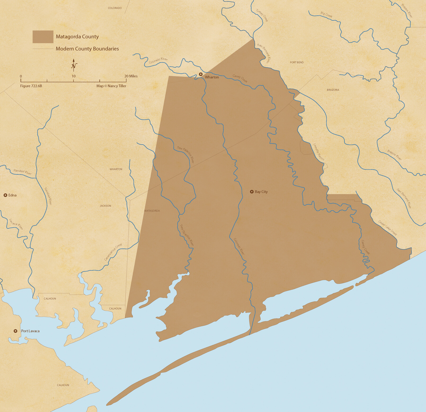
The Republic County of Matagorda. 1841
Figure No. 722.6 from 'A Boundary Atlas of Texas, 1821-1845' by Jim Tiller
-
Map/Doc
96219
-
Collection
Nancy and Jim Tiller Digital Collection
-
Object Dates
2020/1/1 (Creation Date)
-
People and Organizations
Jim Tiller (Author)
Nancy Tiller (Cartographer)
Gang Gong (GIS Professional)
-
Counties
Matagorda
-
Subjects
Atlas County Republic of Texas Texas Boundaries
-
Height x Width
21.0 x 21.7 inches
53.3 x 55.1 cm
-
Medium
digital image
-
Comments
To purchase a digital PDF copy of "A Boundary Atlas of Texas, 1821-1845" see 96437.
Part of: Nancy and Jim Tiller Digital Collection
The Republic County of Jackson. Spring 1842

Print $20.00
The Republic County of Jackson. Spring 1842
2020
Size 15.6 x 21.8 inches
Map/Doc 96190
The Republic County of Bexar. Spring 1842

Print $20.00
The Republic County of Bexar. Spring 1842
2020
Size 14.7 x 21.7 inches
Map/Doc 96100
The Judicial District/County of Burleson. Created, January 15, 1842

Print $20.00
The Judicial District/County of Burleson. Created, January 15, 1842
2020
Size 14.1 x 21.7 inches
Map/Doc 96320
McMullen and McGloin Empresario Colony. August 16, 1828

Print $20.00
McMullen and McGloin Empresario Colony. August 16, 1828
2020
Size 17.6 x 21.7 inches
Map/Doc 95998
The Republic County of San Patricio. December 2, 1841

Print $20.00
The Republic County of San Patricio. December 2, 1841
2020
Size 22.2 x 21.7 inches
Map/Doc 96277
The Republic County of Austin. February 1, 1844

Print $20.00
The Republic County of Austin. February 1, 1844
2020
Size 14.7 x 21.7 inches
Map/Doc 96087
Letter from Jesse Grimes Suggesting a Redefinition of the Boundary Between Harris and Montgomery Counties, April 30, 1838

Print $20.00
Letter from Jesse Grimes Suggesting a Redefinition of the Boundary Between Harris and Montgomery Counties, April 30, 1838
2020
Size 15.4 x 21.7 inches
Map/Doc 96381
The Mexican Municipality of Jackson. Created, December 5, 1835

Print $20.00
The Mexican Municipality of Jackson. Created, December 5, 1835
2020
Size 17.7 x 21.7 inches
Map/Doc 96023
The Republic County of Gonzales. December 18, 1837

Print $20.00
The Republic County of Gonzales. December 18, 1837
2020
Size 14.7 x 21.7 inches
Map/Doc 96154
Burnet Empresario Colony. December 22, 1826

Print $20.00
Burnet Empresario Colony. December 22, 1826
2020
Size 12.9 x 21.6 inches
Map/Doc 95985
The Judicial District/County of Trinity. Abolished, Spring 1842

Print $20.00
The Judicial District/County of Trinity. Abolished, Spring 1842
2020
Size 14.7 x 21.7 inches
Map/Doc 96351
The Republic County of Gonzales. May 3, 1838

Print $20.00
The Republic County of Gonzales. May 3, 1838
2020
Size 14.7 x 21.7 inches
Map/Doc 96155
You may also like
Eastern Hemisphere

Print $20.00
- Digital $50.00
Eastern Hemisphere
1885
Size 12.2 x 9.0 inches
Map/Doc 93511
Gaines County Working Sketch 35

Print $20.00
- Digital $50.00
Gaines County Working Sketch 35
1991
Size 36.4 x 42.8 inches
Map/Doc 69335
Flight Mission No. CRK-3P, Frame 131, Refugio County

Print $20.00
- Digital $50.00
Flight Mission No. CRK-3P, Frame 131, Refugio County
1956
Size 18.5 x 22.4 inches
Map/Doc 86919
Webb County Working Sketch 27

Print $20.00
- Digital $50.00
Webb County Working Sketch 27
1932
Size 24.0 x 19.5 inches
Map/Doc 72392
Atascosa County Rolled Sketch 17

Print $20.00
- Digital $50.00
Atascosa County Rolled Sketch 17
1953
Size 35.6 x 28.2 inches
Map/Doc 5097
[Surveys in the Bexar District along the Guadalupe River and Cibolo Creek]
![3169, [Surveys in the Bexar District along the Guadalupe River and Cibolo Creek], General Map Collection](https://historictexasmaps.com/wmedia_w700/maps/3169.tif.jpg)
Print $20.00
- Digital $50.00
[Surveys in the Bexar District along the Guadalupe River and Cibolo Creek]
1846
Size 9.6 x 18.3 inches
Map/Doc 3169
DeWitt County Sketch File 2

Print $40.00
- Digital $50.00
DeWitt County Sketch File 2
1868
Size 13.0 x 12.2 inches
Map/Doc 20799
Tom Green County Sketch File 39

Print $40.00
- Digital $50.00
Tom Green County Sketch File 39
1881
Size 14.8 x 18.6 inches
Map/Doc 76002
Jefferson County Rolled Sketch 33

Print $20.00
- Digital $50.00
Jefferson County Rolled Sketch 33
1956
Size 46.8 x 27.5 inches
Map/Doc 6393
Cherokee County Sketch File 29

Print $2.00
- Digital $50.00
Cherokee County Sketch File 29
Size 12.9 x 8.2 inches
Map/Doc 18175
Map of Martin County

Print $20.00
- Digital $50.00
Map of Martin County
1900
Size 41.9 x 35.0 inches
Map/Doc 4789
Tyler County Sketch File 9

Print $4.00
- Digital $50.00
Tyler County Sketch File 9
Size 8.6 x 6.7 inches
Map/Doc 38644