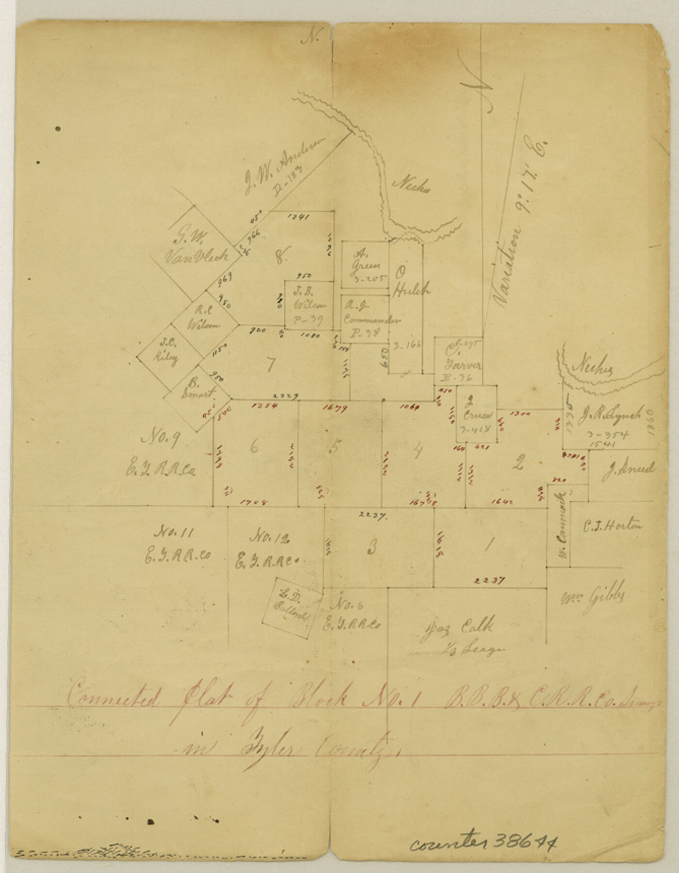
Tyler County Sketch File 9
[Connected plat of Block 1, B. B. B. & C. R.R. Co. surveys in the north part of the county]
-
Map/Doc
38644
-
Collection
General Map Collection
-
Object Dates
12/21/1875 (File Date)
-
Counties
Tyler
-
Subjects
Surveying Sketch File
-
Height x Width
8.6 x 6.7 inches
21.8 x 17.0 cm
-
Medium
paper, manuscript
-
Features
Neches River
Part of: General Map Collection
Current Miscellaneous File 4

Print $8.00
- Digital $50.00
Current Miscellaneous File 4
1947
Size 11.5 x 9.1 inches
Map/Doc 73723
Panola County Working Sketch 17

Print $40.00
- Digital $50.00
Panola County Working Sketch 17
1945
Map/Doc 71426
Flight Mission No. DQN-2K, Frame 187, Calhoun County

Print $20.00
- Digital $50.00
Flight Mission No. DQN-2K, Frame 187, Calhoun County
1953
Size 18.4 x 22.2 inches
Map/Doc 84328
Lipscomb County Working Sketch 2

Print $20.00
- Digital $50.00
Lipscomb County Working Sketch 2
1959
Size 33.4 x 36.6 inches
Map/Doc 70578
Stonewall County Rolled Sketch 30

Print $20.00
- Digital $50.00
Stonewall County Rolled Sketch 30
Size 25.5 x 37.3 inches
Map/Doc 7874
Flight Mission No. DQN-1K, Frame 122, Calhoun County

Print $20.00
- Digital $50.00
Flight Mission No. DQN-1K, Frame 122, Calhoun County
1953
Size 18.5 x 22.2 inches
Map/Doc 84188
Flight Mission No. CRK-3P, Frame 176, Refugio County

Print $20.00
- Digital $50.00
Flight Mission No. CRK-3P, Frame 176, Refugio County
1956
Size 18.3 x 22.2 inches
Map/Doc 86923
Trinity County

Print $20.00
- Digital $50.00
Trinity County
1946
Size 40.5 x 40.7 inches
Map/Doc 77440
San Patricio County Working Sketch 12

Print $40.00
- Digital $50.00
San Patricio County Working Sketch 12
Size 51.4 x 40.7 inches
Map/Doc 63774
Right of Way and Track Map Houston & Texas Central R.R. operated by the T. & N.O. R.R. Co., Austin Branch

Print $40.00
- Digital $50.00
Right of Way and Track Map Houston & Texas Central R.R. operated by the T. & N.O. R.R. Co., Austin Branch
1918
Size 25.8 x 57.8 inches
Map/Doc 64558
Harris County Working Sketch 63

Print $20.00
- Digital $50.00
Harris County Working Sketch 63
1954
Size 34.0 x 36.8 inches
Map/Doc 65955
United States - Gulf Coast - Galveston to Rio Grande

Print $20.00
- Digital $50.00
United States - Gulf Coast - Galveston to Rio Grande
1941
Size 27.2 x 18.2 inches
Map/Doc 72753
You may also like
Harris County Rolled Sketch 88

Print $20.00
- Digital $50.00
Harris County Rolled Sketch 88
1937
Size 34.8 x 22.8 inches
Map/Doc 6127
San Jacinto River and Tributaries, Texas - Survey of 1939

Print $20.00
- Digital $50.00
San Jacinto River and Tributaries, Texas - Survey of 1939
1939
Size 27.7 x 40.4 inches
Map/Doc 60306
Flight Mission No. BRA-6M, Frame 87, Jefferson County

Print $20.00
- Digital $50.00
Flight Mission No. BRA-6M, Frame 87, Jefferson County
1953
Size 18.5 x 22.3 inches
Map/Doc 85430
Stonewall County Working Sketch 11

Print $20.00
- Digital $50.00
Stonewall County Working Sketch 11
1950
Size 23.8 x 33.7 inches
Map/Doc 62318
Hunt County Rolled Sketch 5

Print $20.00
- Digital $50.00
Hunt County Rolled Sketch 5
1956
Size 27.5 x 24.3 inches
Map/Doc 6269
Webb County Rolled Sketch 67

Print $20.00
- Digital $50.00
Webb County Rolled Sketch 67
1927
Size 31.4 x 32.0 inches
Map/Doc 10130
Hamilton County Rolled Sketch 7

Print $20.00
- Digital $50.00
Hamilton County Rolled Sketch 7
1927
Size 32.2 x 38.4 inches
Map/Doc 6057
Flight Mission No. CLL-3N, Frame 18, Willacy County

Print $20.00
- Digital $50.00
Flight Mission No. CLL-3N, Frame 18, Willacy County
1954
Size 18.4 x 22.1 inches
Map/Doc 87084
Pecos County Rolled Sketch 179

Print $20.00
- Digital $50.00
Pecos County Rolled Sketch 179
1980
Size 28.0 x 28.2 inches
Map/Doc 7299
Real County Working Sketch 78

Print $20.00
- Digital $50.00
Real County Working Sketch 78
1980
Size 33.9 x 35.5 inches
Map/Doc 71970
Andrews County Sketch File 17

Print $8.00
- Digital $50.00
Andrews County Sketch File 17
Size 11.1 x 8.6 inches
Map/Doc 12901
The Judicial District/County of Guadalupe. Created, January 29, 1842

Print $20.00
The Judicial District/County of Guadalupe. Created, January 29, 1842
2020
Size 16.7 x 21.7 inches
Map/Doc 96327