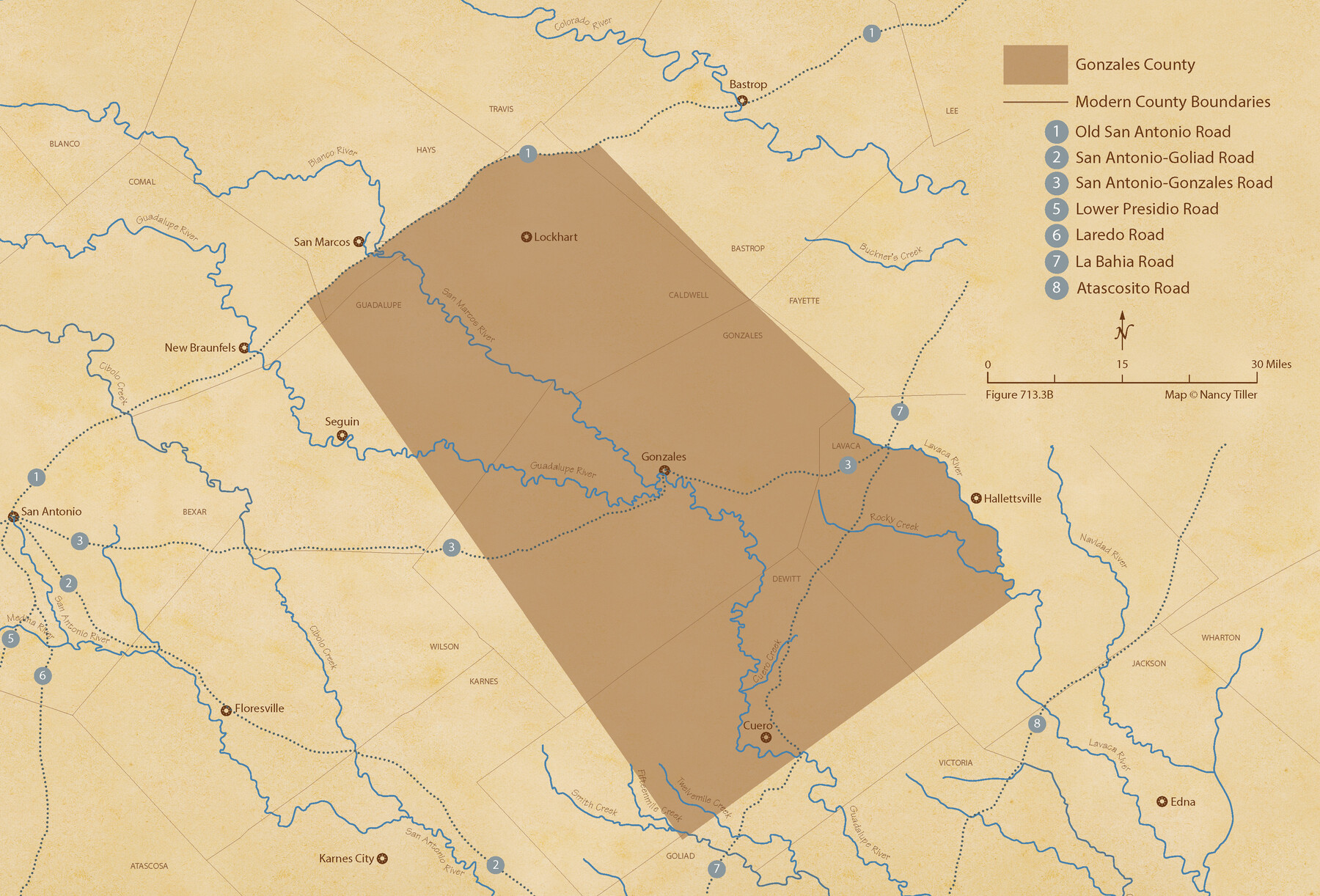
The Republic County of Gonzales. May 3, 1838
Figure No. 713.3 from 'A Boundary Atlas of Texas, 1821-1845' by Jim Tiller
-
Map/Doc
96155
-
Collection
Nancy and Jim Tiller Digital Collection
-
Object Dates
2020/1/1 (Creation Date)
-
People and Organizations
Jim Tiller (Author)
Nancy Tiller (Cartographer)
Gang Gong (GIS Professional)
-
Counties
Gonzales
-
Subjects
Atlas County Republic of Texas Texas Boundaries
-
Height x Width
14.7 x 21.7 inches
37.3 x 55.1 cm
-
Medium
digital image
-
Comments
To purchase a digital PDF copy of "A Boundary Atlas of Texas, 1821-1845" see 96437.
Part of: Nancy and Jim Tiller Digital Collection
The Land Offices. No. 4, Nacogdoches, December 22, 1836

Print $20.00
The Land Offices. No. 4, Nacogdoches, December 22, 1836
2020
Size 14.8 x 21.7 inches
Map/Doc 96417
The Republic County of Shelby. Spring 1842

Print $20.00
The Republic County of Shelby. Spring 1842
2020
Size 20.0 x 21.7 inches
Map/Doc 96284
The Republic County of San Patricio. Proposed, Late Fall 1837

Print $20.00
The Republic County of San Patricio. Proposed, Late Fall 1837
2020
Size 17.8 x 21.7 inches
Map/Doc 96273
The Republic County of Jackson. Boundaries Defined, December 29, 1837

Print $20.00
The Republic County of Jackson. Boundaries Defined, December 29, 1837
2020
Size 15.6 x 21.8 inches
Map/Doc 96184
The Republic County of Gonzales. Boundaries Defined, December 14, 1837

Print $20.00
The Republic County of Gonzales. Boundaries Defined, December 14, 1837
2020
Size 14.7 x 21.7 inches
Map/Doc 96153
The Judicial District/County of DeWitt. Abolished, Spring 1842

Print $20.00
The Judicial District/County of DeWitt. Abolished, Spring 1842
2020
Size 22.4 x 21.7 inches
Map/Doc 96326
From Citizens of Austin County Requesting to be Attached to Washington County, January 4, 1842

Print $20.00
From Citizens of Austin County Requesting to be Attached to Washington County, January 4, 1842
2020
Size 20.2 x 21.7 inches
Map/Doc 96396
Republic Counties. January 1, 1839

Print $20.00
Republic Counties. January 1, 1839
2020
Size 24.5 x 21.7 inches
Map/Doc 96312
From Citizens of Austin County Requesting to be Attached to Washington County, Undated

Print $20.00
From Citizens of Austin County Requesting to be Attached to Washington County, Undated
2020
Size 18.8 x 21.7 inches
Map/Doc 96398
The Republic County of Brazoria. Proposed, Late Fall 1837

Print $20.00
The Republic County of Brazoria. Proposed, Late Fall 1837
2020
Size 13.0 x 21.7 inches
Map/Doc 96109
The Republic County of Jasper. January 29, 1842

Print $20.00
The Republic County of Jasper. January 29, 1842
2020
Size 19.5 x 21.7 inches
Map/Doc 96194
The Chief Justice County of Liberty. April 25, 1837

Print $20.00
The Chief Justice County of Liberty. April 25, 1837
2020
Size 20.5 x 21.7 inches
Map/Doc 96055
You may also like
Orange County Working Sketch 37

Print $40.00
- Digital $50.00
Orange County Working Sketch 37
1962
Size 37.7 x 54.0 inches
Map/Doc 71369
Flight Mission No. DQN-5K, Frame 145, Calhoun County

Print $20.00
- Digital $50.00
Flight Mission No. DQN-5K, Frame 145, Calhoun County
1953
Size 18.5 x 22.1 inches
Map/Doc 84420
Burleson County Working Sketch 16

Print $3.00
- Digital $50.00
Burleson County Working Sketch 16
1980
Size 10.1 x 14.1 inches
Map/Doc 67735
No. 2 Chart of Corpus Christi Pass, Texas

Print $20.00
- Digital $50.00
No. 2 Chart of Corpus Christi Pass, Texas
1878
Size 18.3 x 27.3 inches
Map/Doc 73024
Lee County Sketch File 5

Print $40.00
- Digital $50.00
Lee County Sketch File 5
Size 12.2 x 15.8 inches
Map/Doc 29686
Flight Mission No. DQN-2K, Frame 137, Calhoun County

Print $20.00
- Digital $50.00
Flight Mission No. DQN-2K, Frame 137, Calhoun County
1953
Size 18.8 x 22.5 inches
Map/Doc 84306
Jefferson County Rolled Sketch 61D

Print $20.00
- Digital $50.00
Jefferson County Rolled Sketch 61D
Size 27.2 x 40.5 inches
Map/Doc 6413
Leon County Sketch File 21

Print $20.00
- Digital $50.00
Leon County Sketch File 21
1931
Size 18.2 x 22.8 inches
Map/Doc 11991
Reeves County Rolled Sketch 33

Print $20.00
- Digital $50.00
Reeves County Rolled Sketch 33
Size 24.2 x 36.5 inches
Map/Doc 7502
Garza County Working Sketch Graphic Index

Print $20.00
- Digital $50.00
Garza County Working Sketch Graphic Index
1928
Size 46.7 x 36.2 inches
Map/Doc 76552
[De Loches County School Land]
![91198, [De Loches County School Land], Twichell Survey Records](https://historictexasmaps.com/wmedia_w700/maps/91198-1.tif.jpg)
Print $20.00
- Digital $50.00
[De Loches County School Land]
Size 20.4 x 35.2 inches
Map/Doc 91198
Connected Map of Austin's Colony

Print $20.00
- Digital $50.00
Connected Map of Austin's Colony
1892
Size 47.1 x 42.8 inches
Map/Doc 76073