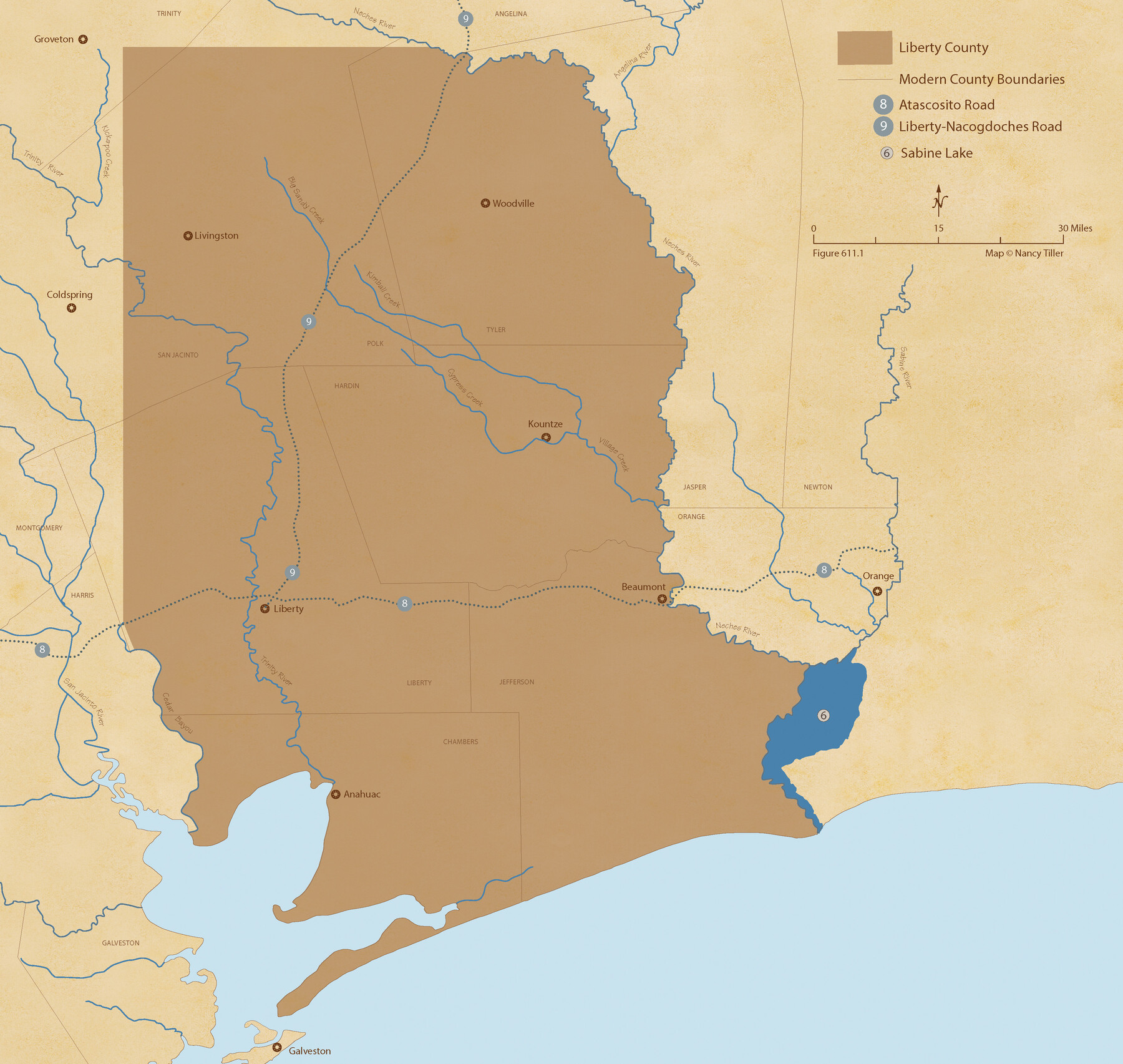
The Chief Justice County of Liberty. April 25, 1837
Figure No. 611.1 from 'A Boundary Atlas of Texas, 1821-1845' by Jim Tiller
-
Map/Doc
96055
-
Collection
Nancy and Jim Tiller Digital Collection
-
Object Dates
2020/1/1 (Creation Date)
-
People and Organizations
Jim Tiller (Author)
Nancy Tiller (Cartographer)
Gang Gong (GIS Professional)
-
Subjects
Atlas Republic of Texas Texas Boundaries
-
Height x Width
20.5 x 21.7 inches
52.1 x 55.1 cm
-
Medium
digital image
-
Comments
To purchase a digital PDF copy of "A Boundary Atlas of Texas, 1821-1845" see 96437.
Part of: Nancy and Jim Tiller Digital Collection
The Republic County of Red River. Boundaries Defined, December 18, 1837

Print $20.00
The Republic County of Red River. Boundaries Defined, December 18, 1837
2020
Size 17.4 x 21.7 inches
Map/Doc 96251
From Citizens of Montgomery and Washington Counties to Redefine the Boundary Between Their Two Counties, Undated

Print $20.00
From Citizens of Montgomery and Washington Counties to Redefine the Boundary Between Their Two Counties, Undated
2020
Size 15.0 x 21.7 inches
Map/Doc 96402
The Republic County of Bexar. December 2, 1841

Print $20.00
The Republic County of Bexar. December 2, 1841
2020
Size 14.8 x 21.7 inches
Map/Doc 96098
The Judicial District/County of Trinity. Abolished, Spring 1842

Print $20.00
The Judicial District/County of Trinity. Abolished, Spring 1842
2020
Size 14.7 x 21.7 inches
Map/Doc 96351
The Mexican Department of Nacogdoches. Created, January 31, 1831

Print $20.00
The Mexican Department of Nacogdoches. Created, January 31, 1831
2020
Size 18.4 x 21.7 inches
Map/Doc 95972
The Judicial District/County of Pashcal. Created, January 28, 1841

Print $20.00
The Judicial District/County of Pashcal. Created, January 28, 1841
2020
Size 15.0 x 21.7 inches
Map/Doc 96343
The Chief Justice County of Red River. Lands in Conflict with Nacogdoches County

Print $20.00
The Chief Justice County of Red River. Lands in Conflict with Nacogdoches County
2020
Size 17.4 x 21.8 inches
Map/Doc 96066
The Republic County of Red River. Spring 1842

Print $20.00
The Republic County of Red River. Spring 1842
2020
Size 21.0 x 21.7 inches
Map/Doc 96254
The Republic County of Bowie. Created, December 17, 1840

Print $20.00
The Republic County of Bowie. Created, December 17, 1840
2020
Size 19.5 x 21.7 inches
Map/Doc 96102
The Republic County of Robertson. November 28, 1839

Print $20.00
The Republic County of Robertson. November 28, 1839
2020
Size 18.9 x 21.6 inches
Map/Doc 96260
The Republic County of Robertson. December 29, 1845

Print $20.00
The Republic County of Robertson. December 29, 1845
2020
Size 16.9 x 21.7 inches
Map/Doc 96264
The Republic County of Colorado. January 1, 1838

Print $20.00
The Republic County of Colorado. January 1, 1838
2020
Size 18.4 x 21.7 inches
Map/Doc 96120
You may also like
Duval County Rolled Sketch 20

Print $20.00
- Digital $50.00
Duval County Rolled Sketch 20
Size 33.2 x 42.0 inches
Map/Doc 8811
Crockett County Sketch File 56

Print $20.00
- Digital $50.00
Crockett County Sketch File 56
Size 19.6 x 19.0 inches
Map/Doc 11224
Duval County Boundary File 1c

Print $12.00
- Digital $50.00
Duval County Boundary File 1c
Size 12.9 x 8.3 inches
Map/Doc 52693
Hunt County Boundary File 8

Print $8.00
- Digital $50.00
Hunt County Boundary File 8
Size 14.6 x 8.9 inches
Map/Doc 55237
Culberson County Working Sketch 83
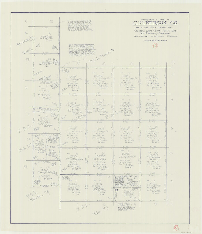
Print $20.00
- Digital $50.00
Culberson County Working Sketch 83
1980
Size 33.4 x 28.9 inches
Map/Doc 68537
Maverick County Sketch File 22

Print $32.00
- Digital $50.00
Maverick County Sketch File 22
1892
Size 5.5 x 6.3 inches
Map/Doc 31136
[Map of the Stockdale-Cuero Extension G.H. & S.A. Ry.]
![64095, [Map of the Stockdale-Cuero Extension G.H. & S.A. Ry.], General Map Collection](https://historictexasmaps.com/wmedia_w700/maps/64095.tif.jpg)
Print $40.00
- Digital $50.00
[Map of the Stockdale-Cuero Extension G.H. & S.A. Ry.]
1905
Size 19.6 x 128.0 inches
Map/Doc 64095
Scurry County Working Sketch 9

Print $20.00
- Digital $50.00
Scurry County Working Sketch 9
1982
Size 37.8 x 43.5 inches
Map/Doc 63838
Miller-Stevens Subdivision Section 16, Block B

Print $20.00
- Digital $50.00
Miller-Stevens Subdivision Section 16, Block B
1944
Size 24.2 x 39.8 inches
Map/Doc 92401
Index sheet to accompany map of survey for connecting the inland waters along margin of the Gulf of Mexico from Donaldsonville in Louisiana to the Rio Grande River in Texas

Print $20.00
- Digital $50.00
Index sheet to accompany map of survey for connecting the inland waters along margin of the Gulf of Mexico from Donaldsonville in Louisiana to the Rio Grande River in Texas
1874
Size 18.2 x 27.1 inches
Map/Doc 72696
Freestone County Sketch File 17

Print $4.00
- Digital $50.00
Freestone County Sketch File 17
1859
Size 6.3 x 8.1 inches
Map/Doc 23074
Travis County Boundary File 25

Print $8.00
- Digital $50.00
Travis County Boundary File 25
Size 9.0 x 6.4 inches
Map/Doc 59459