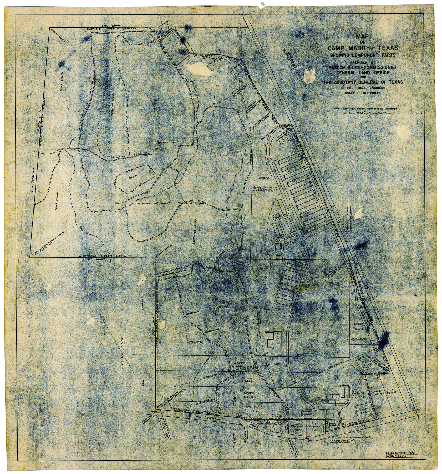
Travis County Rolled Sketch 38
Map of Camp Mabry - Texas showing component parts
-
Map/Doc
8038
-
Collection
General Map Collection
-
People and Organizations
Curtis R. Hale (Surveyor/Engineer)
-
Counties
Travis
-
Subjects
Surveying Rolled Sketch
-
Height x Width
31.9 x 30.3 inches
81.0 x 77.0 cm
-
Medium
blueprint/diazo
-
Scale
1" = 200 feet
Part of: General Map Collection
Pecos County Rolled Sketch 56

Print $20.00
- Digital $50.00
Pecos County Rolled Sketch 56
1916
Size 18.1 x 24.2 inches
Map/Doc 5229
Shackelford County Sketch File 8

Print $44.00
- Digital $50.00
Shackelford County Sketch File 8
1936
Size 11.5 x 8.8 inches
Map/Doc 59290
Clay County Boundary File 12

Print $8.00
- Digital $50.00
Clay County Boundary File 12
Size 14.3 x 8.8 inches
Map/Doc 51406
Intracoastal Waterway - Galveston Bay to West Bay including Galveston Bay Entrance

Print $20.00
- Digital $50.00
Intracoastal Waterway - Galveston Bay to West Bay including Galveston Bay Entrance
1957
Size 27.2 x 38.6 inches
Map/Doc 69933
Hudspeth County Sketch File 30

Print $8.00
- Digital $50.00
Hudspeth County Sketch File 30
1950
Size 11.3 x 8.8 inches
Map/Doc 26986
Colorado County Working Sketch 23

Print $20.00
- Digital $50.00
Colorado County Working Sketch 23
1967
Size 38.0 x 32.9 inches
Map/Doc 68123
Flight Mission No. DCL-7C, Frame 51, Kenedy County

Print $20.00
- Digital $50.00
Flight Mission No. DCL-7C, Frame 51, Kenedy County
1943
Size 16.6 x 16.4 inches
Map/Doc 86039
National Map Company's Map of Texas showing counties, cities, towns, villages and post offices, steam and electric railways with stations and distance between stations

Print $40.00
- Digital $50.00
National Map Company's Map of Texas showing counties, cities, towns, villages and post offices, steam and electric railways with stations and distance between stations
1920
Size 50.3 x 51.1 inches
Map/Doc 10749
Calcasieu Pass to Sabine Pass

Print $20.00
- Digital $50.00
Calcasieu Pass to Sabine Pass
1992
Size 44.5 x 35.8 inches
Map/Doc 69815
Pecos County Rolled Sketch 25B

Print $20.00
- Digital $50.00
Pecos County Rolled Sketch 25B
1892
Size 22.2 x 16.0 inches
Map/Doc 7210
Flight Mission No. CRC-1R, Frame 96, Chambers County

Print $20.00
- Digital $50.00
Flight Mission No. CRC-1R, Frame 96, Chambers County
1956
Size 18.6 x 22.3 inches
Map/Doc 84711
Kendall County Working Sketch 13

Print $20.00
- Digital $50.00
Kendall County Working Sketch 13
1959
Size 25.5 x 30.5 inches
Map/Doc 66685
You may also like
Mineral Locality Map of Texas Showing Occurances of Useful Minerals, Rocks, Oil and Gas, and Other Geologic Substances

Print $40.00
- Digital $50.00
Mineral Locality Map of Texas Showing Occurances of Useful Minerals, Rocks, Oil and Gas, and Other Geologic Substances
1945
Size 43.8 x 53.0 inches
Map/Doc 94140
Map of Nolan County

Print $20.00
- Digital $50.00
Map of Nolan County
1902
Size 45.9 x 38.4 inches
Map/Doc 16780
Gillespie County Working Sketch 6

Print $20.00
- Digital $50.00
Gillespie County Working Sketch 6
1981
Size 22.5 x 21.6 inches
Map/Doc 63169
Map of Voss, Texas, Coleman County

Print $20.00
- Digital $50.00
Map of Voss, Texas, Coleman County
Size 15.8 x 16.0 inches
Map/Doc 81519
Jefferson County Rolled Sketch 61E

Print $20.00
- Digital $50.00
Jefferson County Rolled Sketch 61E
1928
Size 27.1 x 40.2 inches
Map/Doc 6414
Real County Rolled Sketch 4

Print $20.00
- Digital $50.00
Real County Rolled Sketch 4
1961
Size 18.7 x 20.4 inches
Map/Doc 7454
Wichita County Rolled Sketch 13

Print $20.00
- Digital $50.00
Wichita County Rolled Sketch 13
Size 25.7 x 16.6 inches
Map/Doc 8250
Isogonic Chart and Meridian Changes, University Land, Hudspeth County, Texas

Print $20.00
- Digital $50.00
Isogonic Chart and Meridian Changes, University Land, Hudspeth County, Texas
Size 28.5 x 34.1 inches
Map/Doc 62953
Lamar County State Real Property Sketch 1

Print $40.00
- Digital $50.00
Lamar County State Real Property Sketch 1
2013
Size 48.0 x 36.0 inches
Map/Doc 93655
Lubbock County Sketch File 6

Print $20.00
- Digital $50.00
Lubbock County Sketch File 6
1902
Size 33.0 x 20.8 inches
Map/Doc 12017
Missouri, Kansas, and Texas Railway

Print $20.00
Missouri, Kansas, and Texas Railway
1878
Size 16.5 x 12.2 inches
Map/Doc 76188
Flight Mission No. CRE-1R, Frame 124, Jackson County

Print $20.00
- Digital $50.00
Flight Mission No. CRE-1R, Frame 124, Jackson County
1956
Size 16.1 x 15.9 inches
Map/Doc 85335