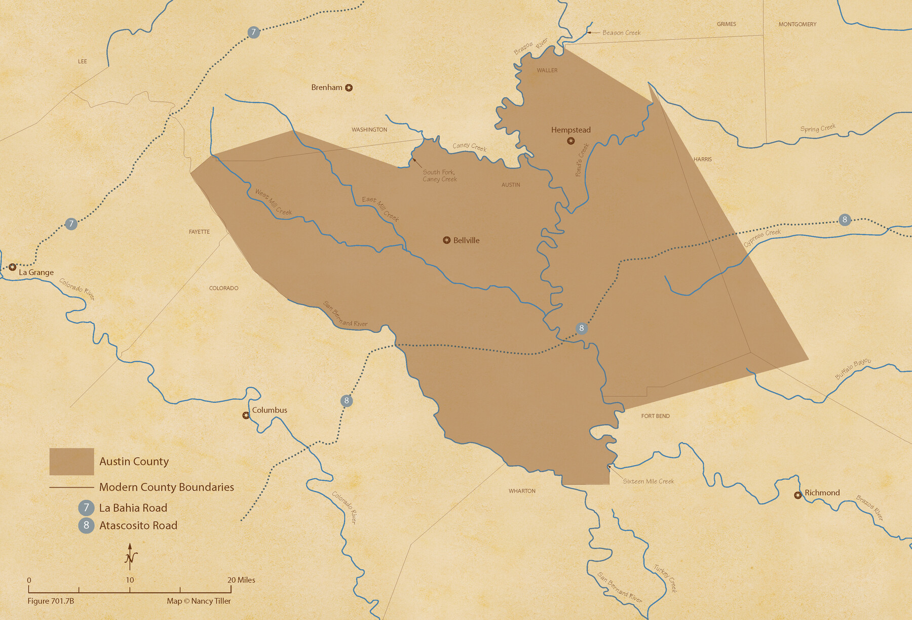
The Republic County of Austin. January 29, 1842
Figure No. 701.7 from 'A Boundary Atlas of Texas, 1821-1845' by Jim Tiller
-
Map/Doc
96086
-
Collection
Nancy and Jim Tiller Digital Collection
-
Object Dates
2020/1/1 (Creation Date)
-
People and Organizations
Jim Tiller (Author)
Nancy Tiller (Cartographer)
Gang Gong (GIS Professional)
-
Counties
Austin
-
Subjects
Atlas County Republic of Texas Texas Boundaries
-
Height x Width
14.7 x 21.7 inches
37.3 x 55.1 cm
-
Medium
digital image
-
Comments
To purchase a digital PDF copy of "A Boundary Atlas of Texas, 1821-1845" see 96437.
Part of: Nancy and Jim Tiller Digital Collection
Cameron Empresario Colony. May 21, 1827

Print $20.00
Cameron Empresario Colony. May 21, 1827
2020
Size 10.7 x 21.7 inches
Map/Doc 95986
The Republic County of Fort Bend. December 29, 1845

Print $20.00
The Republic County of Fort Bend. December 29, 1845
2020
Size 14.7 x 21.6 inches
Map/Doc 96142
Republic Counties. January 1, 1844

Print $20.00
Republic Counties. January 1, 1844
2020
Size 24.5 x 21.7 inches
Map/Doc 96317
The Judicial District/County of Trinity. Abolished, Spring 1842

Print $20.00
The Judicial District/County of Trinity. Abolished, Spring 1842
2020
Size 14.7 x 21.7 inches
Map/Doc 96351
A Boundary Atlas of Texas, 1821-1845

Digital $50.00
A Boundary Atlas of Texas, 1821-1845
2020
Map/Doc 96437
The Republic County of Bexar. December 2, 1841

Print $20.00
The Republic County of Bexar. December 2, 1841
2020
Size 14.8 x 21.7 inches
Map/Doc 96098
The Chief Justice County of San Augustine. April 22, 1837

Print $20.00
The Chief Justice County of San Augustine. April 22, 1837
2020
Size 14.6 x 21.7 inches
Map/Doc 96070
The Republic County of Robertson. November 28, 1839

Print $20.00
The Republic County of Robertson. November 28, 1839
2020
Size 18.9 x 21.6 inches
Map/Doc 96260
The Republic County of Fayette. May 3, 1838

Print $20.00
The Republic County of Fayette. May 3, 1838
2020
Size 14.7 x 21.7 inches
Map/Doc 96132
The Republic County of Fort Bend. Created, December 29, 1837

Print $20.00
The Republic County of Fort Bend. Created, December 29, 1837
2020
Size 14.7 x 21.6 inches
Map/Doc 96137
The Republic County of Harris. Spring 1842

Print $20.00
The Republic County of Harris. Spring 1842
2020
Size 17.7 x 21.7 inches
Map/Doc 96167
The Republic County of Washington. February 4, 1840

Print $20.00
The Republic County of Washington. February 4, 1840
2020
Size 20.3 x 21.7 inches
Map/Doc 96304
You may also like
Menard County Sketch File 2

Print $22.00
- Digital $50.00
Menard County Sketch File 2
1881
Size 7.9 x 12.8 inches
Map/Doc 31486
Fort Bend Co.

Print $20.00
- Digital $50.00
Fort Bend Co.
1931
Size 40.2 x 41.8 inches
Map/Doc 95500
Val Verde County Rolled Sketch 57

Print $40.00
- Digital $50.00
Val Verde County Rolled Sketch 57
1947
Size 53.6 x 48.9 inches
Map/Doc 10077
Brewster County Working Sketch 86

Print $20.00
- Digital $50.00
Brewster County Working Sketch 86
1973
Size 27.6 x 27.7 inches
Map/Doc 67686
Dimmit County Sketch File 56

Print $20.00
- Digital $50.00
Dimmit County Sketch File 56
1939
Size 15.8 x 27.4 inches
Map/Doc 11360
General Highway Map, Caldwell County, Texas

Print $20.00
General Highway Map, Caldwell County, Texas
1961
Size 18.3 x 24.6 inches
Map/Doc 79394
Castro County Sketch File 16

Print $4.00
- Digital $50.00
Castro County Sketch File 16
1891
Size 11.0 x 8.8 inches
Map/Doc 17513
Liberty County Working Sketch 27

Print $20.00
- Digital $50.00
Liberty County Working Sketch 27
1942
Size 22.1 x 25.2 inches
Map/Doc 70486
Pecos County Working Sketch 138

Print $20.00
- Digital $50.00
Pecos County Working Sketch 138
1981
Size 23.2 x 26.3 inches
Map/Doc 71612
2008 Official Travel Map Texas

Digital $50.00
2008 Official Travel Map Texas
Size 33.5 x 36.4 inches
Map/Doc 94309
Flight Mission No. CLL-1N, Frame 191, Willacy County

Print $20.00
- Digital $50.00
Flight Mission No. CLL-1N, Frame 191, Willacy County
1954
Size 18.3 x 22.0 inches
Map/Doc 87061
Flight Mission No. CRK-3P, Frame 61, Refugio County

Print $20.00
- Digital $50.00
Flight Mission No. CRK-3P, Frame 61, Refugio County
1956
Size 18.7 x 22.5 inches
Map/Doc 86903