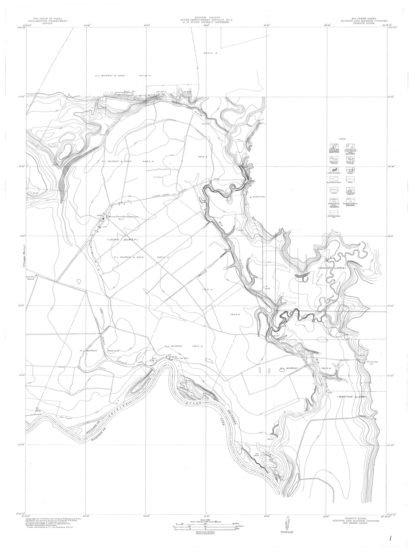
Trinity River, Big Creek Sheet
-
Map/Doc
65179
-
Collection
General Map Collection
-
Object Dates
1924 (Creation Date)
-
People and Organizations
Texas State Reclamation Department (Publisher)
E.J. von Rosenberg (Compiler)
E.J. von Rosenberg (Draftsman)
F.R. Poston (Surveyor/Engineer)
R.W. Stiles (Surveyor/Engineer)
S.T. Penick (Surveyor/Engineer)
-
Counties
Houston Madison
-
Subjects
River Surveys Topographic
-
Height x Width
48.0 x 36.4 inches
121.9 x 92.5 cm
-
Comments
Big Creek Sheet located east of the Clapps Ferry Sheet.
Part of: General Map Collection
McClennan County

Print $20.00
- Digital $50.00
McClennan County
1880
Size 23.6 x 25.4 inches
Map/Doc 4596
Montgomery County Working Sketch 11

Print $20.00
- Digital $50.00
Montgomery County Working Sketch 11
1933
Size 25.2 x 17.7 inches
Map/Doc 71118
Road Map of Cameron County Texas

Print $20.00
- Digital $50.00
Road Map of Cameron County Texas
1938
Size 20.3 x 24.9 inches
Map/Doc 62181
[Surveys in Austin's Colony along the Colorado River]
![198, [Surveys in Austin's Colony along the Colorado River], General Map Collection](https://historictexasmaps.com/wmedia_w700/maps/198.tif.jpg)
Print $20.00
- Digital $50.00
[Surveys in Austin's Colony along the Colorado River]
1830
Size 38.9 x 23.2 inches
Map/Doc 198
Menard County Working Sketch 24

Print $20.00
- Digital $50.00
Menard County Working Sketch 24
1950
Size 38.1 x 22.6 inches
Map/Doc 70971
Calhoun County Rolled Sketch 30

Print $20.00
- Digital $50.00
Calhoun County Rolled Sketch 30
1974
Size 18.5 x 27.6 inches
Map/Doc 5492
Rockwall County

Print $20.00
- Digital $50.00
Rockwall County
1941
Size 26.0 x 21.3 inches
Map/Doc 77410
Sketch of Colorado Co. presented by Mr. Mason

Print $2.00
- Digital $50.00
Sketch of Colorado Co. presented by Mr. Mason
1845
Size 14.3 x 8.2 inches
Map/Doc 69736
Map of the Recognised Line M. El. P. & P. R.R. from Texas & Arkansas State Line to Milam & Bexar Land District Line

Print $40.00
- Digital $50.00
Map of the Recognised Line M. El. P. & P. R.R. from Texas & Arkansas State Line to Milam & Bexar Land District Line
1856
Size 14.3 x 89.8 inches
Map/Doc 64053
Hunt County Sketch File 2

Print $4.00
- Digital $50.00
Hunt County Sketch File 2
1857
Size 10.1 x 7.8 inches
Map/Doc 27083
Montgomery County Working Sketch 21

Print $20.00
- Digital $50.00
Montgomery County Working Sketch 21
1936
Size 16.4 x 37.0 inches
Map/Doc 71128
Jackson County Rolled Sketch 6

Print $20.00
- Digital $50.00
Jackson County Rolled Sketch 6
1914
Size 23.6 x 26.6 inches
Map/Doc 6341
You may also like
Upton County Working Sketch 44

Print $20.00
- Digital $50.00
Upton County Working Sketch 44
1962
Size 19.2 x 25.5 inches
Map/Doc 69540
Gaines County Sketch File 6

Print $20.00
- Digital $50.00
Gaines County Sketch File 6
1924
Size 20.9 x 21.3 inches
Map/Doc 11523
Anderson County Sketch File 18

Print $40.00
- Digital $50.00
Anderson County Sketch File 18
1880
Size 16.0 x 13.5 inches
Map/Doc 10801
Marion County Rolled Sketch 10

Print $20.00
- Digital $50.00
Marion County Rolled Sketch 10
2023
Size 24.1 x 36.9 inches
Map/Doc 97192
Flight Mission No. DQN-5K, Frame 30, Calhoun County

Print $20.00
- Digital $50.00
Flight Mission No. DQN-5K, Frame 30, Calhoun County
1953
Size 16.7 x 16.5 inches
Map/Doc 84381
[Map Showing Surveys in Dimmit & La Salle Counties, Texas]
![75791, [Map Showing Surveys in Dimmit & La Salle Counties, Texas], Maddox Collection](https://historictexasmaps.com/wmedia_w700/maps/75791.tif.jpg)
Print $20.00
- Digital $50.00
[Map Showing Surveys in Dimmit & La Salle Counties, Texas]
Size 29.5 x 29.5 inches
Map/Doc 75791
Anderson County Working Sketch 33

Print $20.00
- Digital $50.00
Anderson County Working Sketch 33
1966
Size 30.8 x 29.9 inches
Map/Doc 67033
Hemphill County Working Sketch 31

Print $20.00
- Digital $50.00
Hemphill County Working Sketch 31
1974
Size 38.8 x 41.1 inches
Map/Doc 66126
Jeff Davis County Sketch File 30

Print $26.00
- Digital $50.00
Jeff Davis County Sketch File 30
1922
Size 14.1 x 8.5 inches
Map/Doc 28014
Go Turnpike! Dallas-Fort Worth Turnpike (Verso)

Go Turnpike! Dallas-Fort Worth Turnpike (Verso)
1963
Size 11.2 x 17.2 inches
Map/Doc 94178
Trinity River, Daugherty Lake Sheet/East Fork of Trinity River

Print $20.00
- Digital $50.00
Trinity River, Daugherty Lake Sheet/East Fork of Trinity River
1920
Size 41.9 x 30.1 inches
Map/Doc 65191
