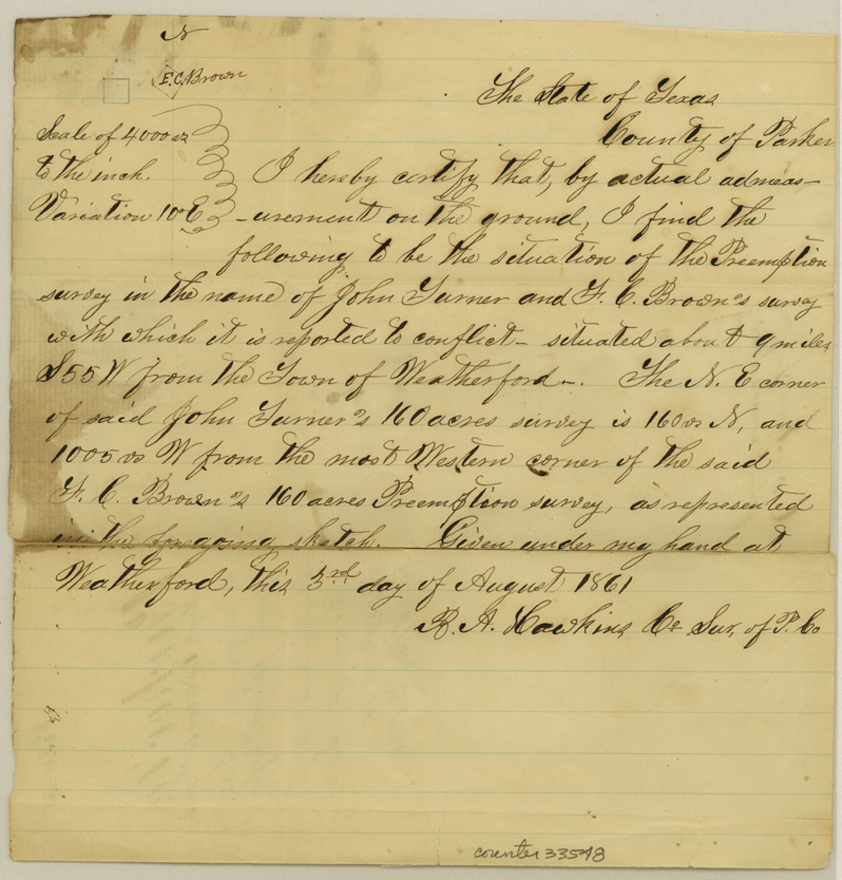
Parker County Sketch File 15
[Sketch and certification regarding conflict between Turner and Brown surveys]
-
Map/Doc
33548
-
Collection
General Map Collection
-
Object Dates
8/3/1861 (Creation Date)
10/9/1861 (File Date)
-
People and Organizations
R.A. Hawkins (Surveyor/Engineer)
-
Counties
Parker
-
Subjects
Surveying Sketch File
-
Height x Width
8.3 x 8.0 inches
21.1 x 20.3 cm
-
Medium
paper, manuscript
-
Scale
1" = 4000 varas
Part of: General Map Collection
Pecos County Sketch File 22

Print $20.00
- Digital $50.00
Pecos County Sketch File 22
1886
Size 14.0 x 8.8 inches
Map/Doc 33670
Dawson County Rolled Sketch 12

Print $20.00
- Digital $50.00
Dawson County Rolled Sketch 12
1965
Size 15.6 x 33.2 inches
Map/Doc 5695
San Patricio County Sketch File 32

Print $20.00
- Digital $50.00
San Patricio County Sketch File 32
Size 13.7 x 30.3 inches
Map/Doc 12287
Map of Lipscomb County

Print $20.00
- Digital $50.00
Map of Lipscomb County
1899
Size 43.1 x 39.2 inches
Map/Doc 5017
Burleson County Sketch File 5

Print $4.00
- Digital $50.00
Burleson County Sketch File 5
Size 12.9 x 8.3 inches
Map/Doc 16649
Hall County Sketch File 29 and 29a

Print $12.00
- Digital $50.00
Hall County Sketch File 29 and 29a
1913
Size 8.9 x 7.9 inches
Map/Doc 24824
Upshur County Sketch File 15

Print $20.00
- Digital $50.00
Upshur County Sketch File 15
1934
Size 20.7 x 31.2 inches
Map/Doc 12505
Mitchell County Working Sketch 9

Print $20.00
- Digital $50.00
Mitchell County Working Sketch 9
1987
Size 25.8 x 41.1 inches
Map/Doc 71066

Rusk County Working Sketch 37c

Print $20.00
- Digital $50.00
Rusk County Working Sketch 37c
2007
Size 21.2 x 36.0 inches
Map/Doc 87498
Schleicher County Working Sketch 23
Print $20.00
- Digital $50.00
Schleicher County Working Sketch 23
1953
Size 42.6 x 40.6 inches
Map/Doc 63825
Flight Mission No. DIX-10P, Frame 165, Aransas County

Print $20.00
- Digital $50.00
Flight Mission No. DIX-10P, Frame 165, Aransas County
1956
Size 18.6 x 22.3 inches
Map/Doc 83955
You may also like
Outline Map showing a New Route from Texas to Fort Yuma, California for Cattle Droves and Trains En route to California

Print $40.00
- Digital $50.00
Outline Map showing a New Route from Texas to Fort Yuma, California for Cattle Droves and Trains En route to California
1880
Size 17.5 x 52.2 inches
Map/Doc 97141
Laneer vs. Bivins, Potter County, Texas

Print $20.00
- Digital $50.00
Laneer vs. Bivins, Potter County, Texas
Size 21.2 x 18.8 inches
Map/Doc 93100
Cooke County Working Sketch 30

Print $20.00
- Digital $50.00
Cooke County Working Sketch 30
1979
Size 26.6 x 28.4 inches
Map/Doc 68267
Scurry County Rolled Sketch 12

Print $20.00
- Digital $50.00
Scurry County Rolled Sketch 12
1983
Size 27.7 x 27.0 inches
Map/Doc 7772
Crockett County Rolled Sketch 42

Print $20.00
- Digital $50.00
Crockett County Rolled Sketch 42
Size 24.4 x 24.7 inches
Map/Doc 5592
Aransas Pass to Baffin Bay

Print $20.00
- Digital $50.00
Aransas Pass to Baffin Bay
1966
Size 42.3 x 35.0 inches
Map/Doc 73415
Panola County Sketch File 7

Print $4.00
- Digital $50.00
Panola County Sketch File 7
Size 7.7 x 9.9 inches
Map/Doc 33457
English Field Notes of the Spanish Archives - Books J.S.2, 3, and 4

English Field Notes of the Spanish Archives - Books J.S.2, 3, and 4
1835
Map/Doc 96550
Flight Mission No. DAG-21K, Frame 83, Matagorda County

Print $20.00
- Digital $50.00
Flight Mission No. DAG-21K, Frame 83, Matagorda County
1952
Size 18.7 x 22.4 inches
Map/Doc 86412
[Capitol Leagues in Lamb County]
![91013, [Capitol Leagues in Lamb County], Twichell Survey Records](https://historictexasmaps.com/wmedia_w700/maps/91013-1.tif.jpg)
Print $2.00
- Digital $50.00
[Capitol Leagues in Lamb County]
1912
Size 13.1 x 8.8 inches
Map/Doc 91013
Hall County Sketch File 11

Print $12.00
- Digital $50.00
Hall County Sketch File 11
1884
Size 12.8 x 8.3 inches
Map/Doc 24808
Kerr County Working Sketch 11

Print $20.00
- Digital $50.00
Kerr County Working Sketch 11
1951
Size 30.3 x 29.9 inches
Map/Doc 70042