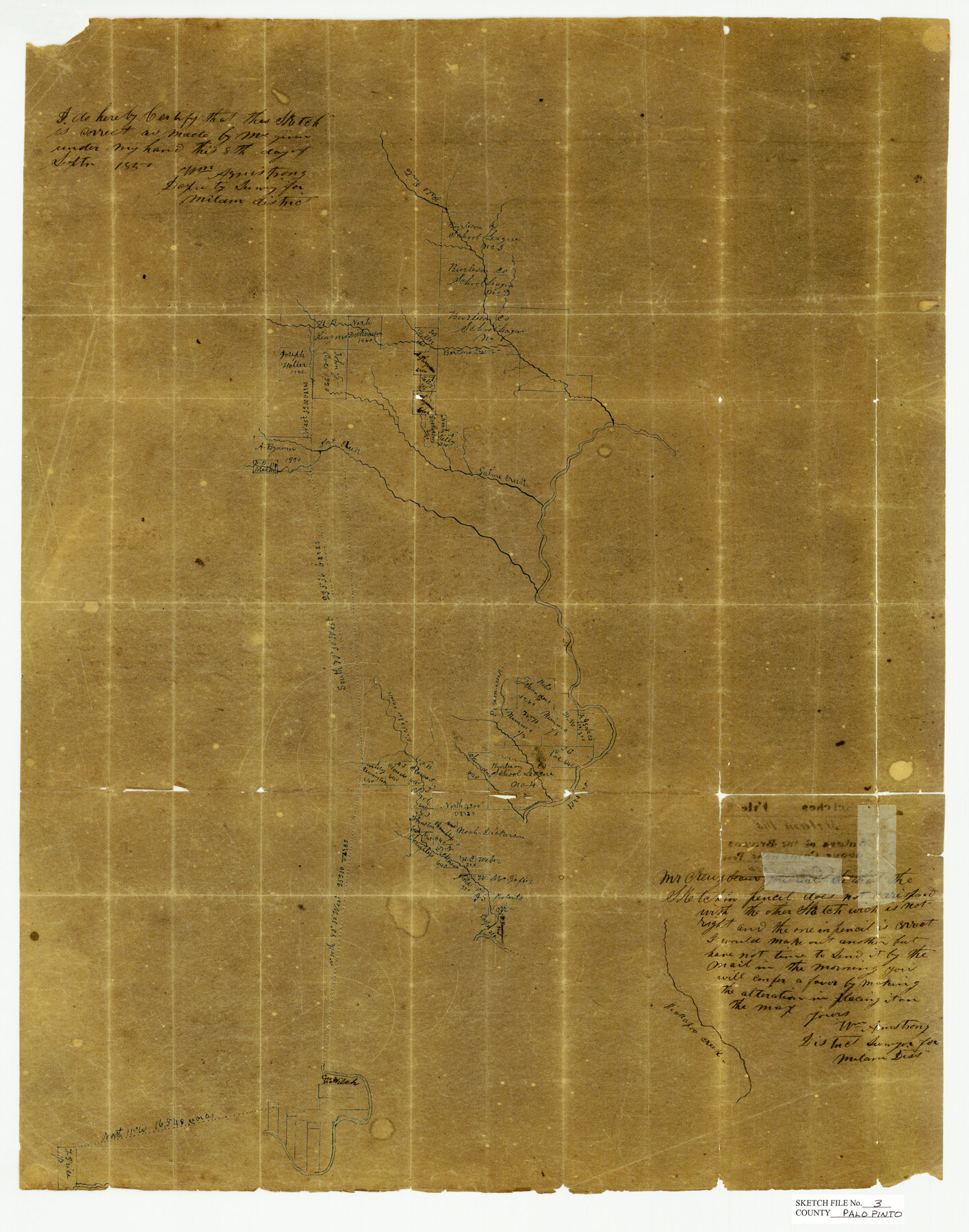
Palo Pinto County Sketch File 3
Waters of the Brazos Above Comanche Peak, Palo Pinto County, Texas
-
Map/Doc
12132
-
Collection
General Map Collection
-
Object Dates
9/8/1850 (Creation Date)
9/12/1850 (File Date)
-
People and Organizations
William Armstrong (Surveyor/Engineer)
-
Counties
Palo Pinto Erath
-
Subjects
Surveying Sketch File
-
Height x Width
24.6 x 19.3 inches
62.5 x 49.0 cm
-
Medium
paper, manuscript
-
Features
Palo Pinto Creek
Barton's Creek
Saline Creek
Fort Creek
Brazos River
Kickapoo Creek
Saunders Creek
Part of: General Map Collection
Stephens County Boundary File 2

Print $34.00
- Digital $50.00
Stephens County Boundary File 2
Size 14.2 x 8.7 inches
Map/Doc 58866
Harris County Sketch File 84

Print $20.00
- Digital $50.00
Harris County Sketch File 84
1950
Size 23.1 x 35.7 inches
Map/Doc 11672
Kaufman County Sketch File 5

Print $22.00
- Digital $50.00
Kaufman County Sketch File 5
1849
Size 7.6 x 12.6 inches
Map/Doc 28632
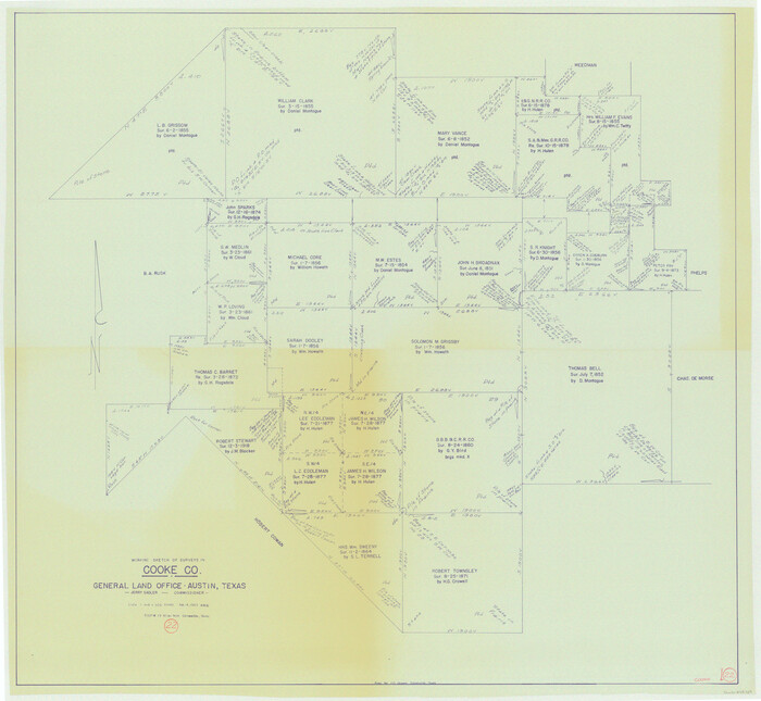
Cooke County Working Sketch 22
Print $20.00
- Digital $50.00
Cooke County Working Sketch 22
1963
Size 37.0 x 40.2 inches
Map/Doc 68259
Refugio County Aerial Photograph Index Sheet 5

Print $20.00
- Digital $50.00
Refugio County Aerial Photograph Index Sheet 5
1957
Size 23.2 x 18.9 inches
Map/Doc 83743
Briscoe County Working Sketch 8

Print $20.00
- Digital $50.00
Briscoe County Working Sketch 8
1947
Size 13.2 x 15.8 inches
Map/Doc 67811
Presidio County Working Sketch 30

Print $20.00
- Digital $50.00
Presidio County Working Sketch 30
1946
Size 32.3 x 40.9 inches
Map/Doc 71707
Presidio County Rolled Sketch 61

Print $20.00
- Digital $50.00
Presidio County Rolled Sketch 61
1914
Size 16.0 x 19.7 inches
Map/Doc 7353
Bowie County Rolled Sketch 5

Print $20.00
- Digital $50.00
Bowie County Rolled Sketch 5
Size 33.1 x 44.5 inches
Map/Doc 8457
Flight Mission No. DIX-6P, Frame 112, Aransas County

Print $20.00
- Digital $50.00
Flight Mission No. DIX-6P, Frame 112, Aransas County
1956
Size 18.9 x 22.7 inches
Map/Doc 83818
[Tom Green County]
![82060, [Tom Green County], General Map Collection](https://historictexasmaps.com/wmedia_w700/maps/82060.tif.jpg)
Print $40.00
- Digital $50.00
[Tom Green County]
1888
Size 45.8 x 113.0 inches
Map/Doc 82060
Karnes County Boundary File 2a

Print $4.00
- Digital $50.00
Karnes County Boundary File 2a
Size 12.7 x 8.1 inches
Map/Doc 55692
You may also like
Territorios de Sierragorda e Isla del Carmen

Print $20.00
- Digital $50.00
Territorios de Sierragorda e Isla del Carmen
Size 22.9 x 31.2 inches
Map/Doc 97011
University of Texas Land Survey Isogonic Chart and Graph of Meridian Changes on University Lands Principally in Andrews County, Texas

Print $20.00
- Digital $50.00
University of Texas Land Survey Isogonic Chart and Graph of Meridian Changes on University Lands Principally in Andrews County, Texas
Size 15.0 x 18.4 inches
Map/Doc 62947
![89869, [Morton], Twichell Survey Records](https://historictexasmaps.com/wmedia_w700/maps/89869-1.tif.jpg)
Collingsworth County Sketch File 5

Print $20.00
- Digital $50.00
Collingsworth County Sketch File 5
1891
Size 32.0 x 24.3 inches
Map/Doc 11132
Map of Wharton County

Print $20.00
- Digital $50.00
Map of Wharton County
1871
Size 22.3 x 23.6 inches
Map/Doc 4135
[Map 1:] A Geographically Correct County Map of States Traversed by the St. Louis, Iron Mountain and Southern Railway and its connections / [Map 2:] Map of the St. Louis, Iron Mountain and Southern Railway, and connections
![95784, [Map 1:] A Geographically Correct County Map of States Traversed by the St. Louis, Iron Mountain and Southern Railway and its connections / [Map 2:] Map of the St. Louis, Iron Mountain and Southern Railway, and connections, Cobb Digital Map Collection - 1](https://historictexasmaps.com/wmedia_w700/maps/95784.tif.jpg)
Print $20.00
- Digital $50.00
[Map 1:] A Geographically Correct County Map of States Traversed by the St. Louis, Iron Mountain and Southern Railway and its connections / [Map 2:] Map of the St. Louis, Iron Mountain and Southern Railway, and connections
1878
Size 18.9 x 32.2 inches
Map/Doc 95784
Aransas County Rolled Sketch 15

Print $20.00
- Digital $50.00
Aransas County Rolled Sketch 15
1889
Size 39.3 x 38.0 inches
Map/Doc 78223
Flight Mission No. BRA-7M, Frame 12, Jefferson County

Print $20.00
- Digital $50.00
Flight Mission No. BRA-7M, Frame 12, Jefferson County
1953
Size 18.5 x 22.3 inches
Map/Doc 85463
McMullen County Sketch File 37

Print $6.00
- Digital $50.00
McMullen County Sketch File 37
1937
Size 14.3 x 8.8 inches
Map/Doc 31410
Goliad County Working Sketch 24

Print $20.00
- Digital $50.00
Goliad County Working Sketch 24
1982
Size 14.9 x 15.7 inches
Map/Doc 63214
Pecos County Working Sketch 10

Print $20.00
- Digital $50.00
Pecos County Working Sketch 10
1907
Size 25.9 x 23.9 inches
Map/Doc 71480
Duval County Working Sketch 27

Print $20.00
- Digital $50.00
Duval County Working Sketch 27
1947
Size 20.7 x 16.8 inches
Map/Doc 68751