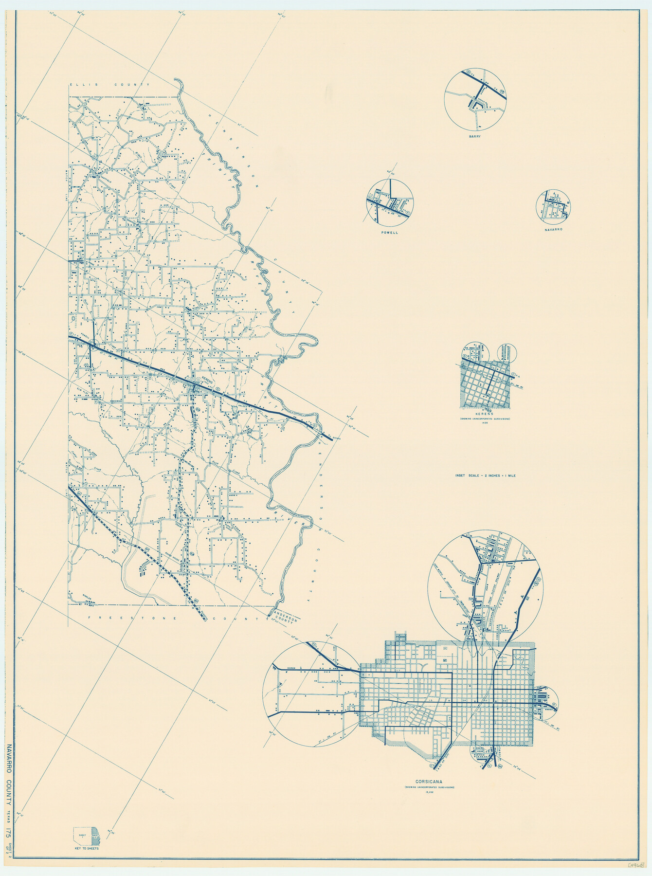
General Highway Map, Navarro County, Texas
-
Map/Doc
79206
-
Collection
Texas State Library and Archives
-
Object Dates
1939 (Creation Date)
-
People and Organizations
Texas State Highway Department (Publisher)
-
Counties
Navarro
-
Subjects
County
-
Height x Width
24.7 x 18.4 inches
62.7 x 46.7 cm
-
Comments
Prints available courtesy of the Texas State Library and Archives.
More info can be found here: TSLAC Map 04960
Part of: Texas State Library and Archives

General Highway Map, Orange County, Texas

Print $20.00
General Highway Map, Orange County, Texas
1940
Size 18.3 x 24.5 inches
Map/Doc 79212
General Highway Map, Dimmit County, Zavala County, Texas

Print $20.00
General Highway Map, Dimmit County, Zavala County, Texas
1961
Size 18.2 x 24.6 inches
Map/Doc 79444
General Highway Map, Fayette County, Texas

Print $20.00
General Highway Map, Fayette County, Texas
1961
Size 18.2 x 24.5 inches
Map/Doc 79465
General Highway Map, El Paso County, Texas

Print $20.00
General Highway Map, El Paso County, Texas
1961
Size 18.2 x 24.7 inches
Map/Doc 79454
General Highway Map, Limestone County, Texas

Print $20.00
General Highway Map, Limestone County, Texas
1940
Size 18.3 x 24.9 inches
Map/Doc 79174
General Highway Map. Detail of Cities and Towns in McLennan County, Texas

Print $20.00
General Highway Map. Detail of Cities and Towns in McLennan County, Texas
1961
Size 18.2 x 24.6 inches
Map/Doc 79591
General Highway Map, Blanco County, Texas

Print $20.00
General Highway Map, Blanco County, Texas
1961
Size 25.0 x 18.2 inches
Map/Doc 79376
General Highway Map, Henderson County, Texas

Print $20.00
General Highway Map, Henderson County, Texas
1961
Size 24.9 x 18.0 inches
Map/Doc 79517
Mexico und Centro-America

Print $20.00
Mexico und Centro-America
1841
Size 14.1 x 17.1 inches
Map/Doc 79732
General Highway Map, Williamson County, Texas

Print $20.00
General Highway Map, Williamson County, Texas
1961
Size 24.8 x 18.2 inches
Map/Doc 79712
Geological Petroleum Corporation Map of North Central Texas

Print $20.00
Geological Petroleum Corporation Map of North Central Texas
1920
Size 37.4 x 28.4 inches
Map/Doc 79305
You may also like
Orange County Rolled Sketch RG

Print $40.00
- Digital $50.00
Orange County Rolled Sketch RG
1919
Size 32.7 x 61.2 inches
Map/Doc 9654
Crockett County, Texas

Print $20.00
- Digital $50.00
Crockett County, Texas
Size 28.8 x 21.4 inches
Map/Doc 90473
Webb County Sketch File 14a

Print $40.00
- Digital $50.00
Webb County Sketch File 14a
1893
Size 17.4 x 13.7 inches
Map/Doc 39810
Lampasas County Working Sketch 1

Print $20.00
- Digital $50.00
Lampasas County Working Sketch 1
Size 16.2 x 20.3 inches
Map/Doc 70278
Hale County Working Sketch 7

Print $20.00
- Digital $50.00
Hale County Working Sketch 7
1963
Size 24.4 x 20.6 inches
Map/Doc 63327
Angelina County Working Sketch 23

Print $20.00
- Digital $50.00
Angelina County Working Sketch 23
1953
Size 19.8 x 32.6 inches
Map/Doc 67105
General Highway Map. Detail of Cities and Towns in Hutchinson County, Texas [Borger, Stinnett and vicinity]
![79530, General Highway Map. Detail of Cities and Towns in Hutchinson County, Texas [Borger, Stinnett and vicinity], Texas State Library and Archives](https://historictexasmaps.com/wmedia_w700/maps/79530.tif.jpg)
Print $20.00
General Highway Map. Detail of Cities and Towns in Hutchinson County, Texas [Borger, Stinnett and vicinity]
1961
Size 24.6 x 18.3 inches
Map/Doc 79530
Texas Coast Showing Points of Occupation of Expedition Under Maj. Gen. N.P. Banks, Novr. 1863

Print $20.00
Texas Coast Showing Points of Occupation of Expedition Under Maj. Gen. N.P. Banks, Novr. 1863
1863
Size 16.0 x 17.1 inches
Map/Doc 88593
Fractional Township No. 7 South Range No. 16 East of the Indian Meridian, Indian Territory

Print $20.00
- Digital $50.00
Fractional Township No. 7 South Range No. 16 East of the Indian Meridian, Indian Territory
1897
Size 19.2 x 24.2 inches
Map/Doc 75229
Grayson County Sketch File 13

Print $40.00
- Digital $50.00
Grayson County Sketch File 13
1853
Size 16.2 x 14.4 inches
Map/Doc 24480
Tyler County Working Sketch 18

Print $20.00
- Digital $50.00
Tyler County Working Sketch 18
1965
Size 31.4 x 27.3 inches
Map/Doc 69488
Map of Texas Gulf Coast and Texas Continental Shelf showing Natural Gas Pipe Lines

Print $40.00
- Digital $50.00
Map of Texas Gulf Coast and Texas Continental Shelf showing Natural Gas Pipe Lines
1973
Size 41.6 x 60.1 inches
Map/Doc 75904