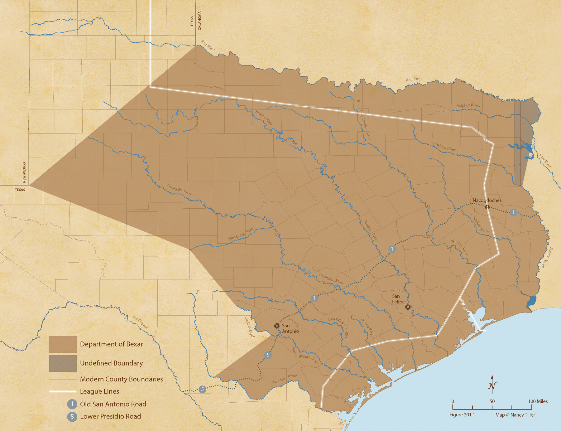
The Mexican Department of Bexar. Created, 1827
Figure No. 201.1 from 'A Boundary Atlas of Texas, 1821-1845' by Jim Tiller
-
Map/Doc
95967
-
Collection
Nancy and Jim Tiller Digital Collection
-
Object Dates
2020/1/1 (Creation Date)
-
People and Organizations
Jim Tiller (Author)
Nancy Tiller (Cartographer)
Gang Gong (GIS Professional)
-
Subjects
Atlas Mexican Texas Texas Boundaries
-
Height x Width
16.6 x 21.7 inches
42.2 x 55.1 cm
-
Medium
digital image
-
Comments
To purchase a digital PDF copy of "A Boundary Atlas of Texas, 1821-1845" see 96437.
Part of: Nancy and Jim Tiller Digital Collection
The Republic County of Nacogdoches. December 29, 1845

Print $20.00
The Republic County of Nacogdoches. December 29, 1845
2020
Size 15.9 x 21.8 inches
Map/Doc 96250
The Republic County of Victoria. January 29, 1842

Print $20.00
The Republic County of Victoria. January 29, 1842
2020
Size 24.3 x 21.7 inches
Map/Doc 96298
The Republic County of Sabine. Boundaries Defined, December14, 1837

Print $20.00
The Republic County of Sabine. Boundaries Defined, December14, 1837
2020
Size 17.6 x 21.7 inches
Map/Doc 96269
The Chief Justice County of Mina. April 24, 1837

Print $20.00
The Chief Justice County of Mina. April 24, 1837
2020
Size 15.8 x 21.7 inches
Map/Doc 96061
The Republic County of Travis. January 29, 1842

Print $20.00
The Republic County of Travis. January 29, 1842
2020
Size 20.8 x 21.6 inches
Map/Doc 96291
The Republic County of Jackson. December 24, 1844

Print $20.00
The Republic County of Jackson. December 24, 1844
2020
Size 15.6 x 21.8 inches
Map/Doc 96191
Zavala Empresario Colony. March 12, 1829

Print $20.00
Zavala Empresario Colony. March 12, 1829
2020
Size 24.7 x 21.7 inches
Map/Doc 96012
Purnell and Lovell Empresario Colony. October 22, 1825

Print $20.00
Purnell and Lovell Empresario Colony. October 22, 1825
2020
Size 18.1 x 21.6 inches
Map/Doc 96005
The Republic County of Red River. December 17, 1840

Print $20.00
The Republic County of Red River. December 17, 1840
2020
Size 17.4 x 21.7 inches
Map/Doc 96252
The Republic County of Matagorda. January 19, 1841

Print $20.00
The Republic County of Matagorda. January 19, 1841
2020
Size 21.0 x 21.7 inches
Map/Doc 96220
The Republic County of Harris. Proposed, Late Fall 1837-May 15, 1838

Print $20.00
The Republic County of Harris. Proposed, Late Fall 1837-May 15, 1838
2020
Size 17.7 x 21.7 inches
Map/Doc 96162
The Chief Justice County of Gonzales. Lands in Conflict with Victoria County

Print $20.00
The Chief Justice County of Gonzales. Lands in Conflict with Victoria County
2020
Size 22.3 x 21.7 inches
Map/Doc 96048
You may also like

Fisher County Rolled Sketch 5

Print $20.00
- Digital $50.00
Fisher County Rolled Sketch 5
1961
Size 40.3 x 32.5 inches
Map/Doc 10659
[Sections 158-162 and surveys to the east]
![93003, [Sections 158-162 and surveys to the east], Twichell Survey Records](https://historictexasmaps.com/wmedia_w700/maps/93003-1.tif.jpg)
Print $20.00
- Digital $50.00
[Sections 158-162 and surveys to the east]
1916
Size 7.8 x 18.9 inches
Map/Doc 93003
Presidio County Rolled Sketch 104

Print $20.00
- Digital $50.00
Presidio County Rolled Sketch 104
1948
Size 26.1 x 40.0 inches
Map/Doc 7386
Menard County

Print $20.00
- Digital $50.00
Menard County
1894
Size 32.5 x 42.1 inches
Map/Doc 66926
Leon County Rolled Sketch 33

Print $20.00
- Digital $50.00
Leon County Rolled Sketch 33
1997
Size 26.3 x 36.7 inches
Map/Doc 6617
Sketch in Dawson County

Print $20.00
- Digital $50.00
Sketch in Dawson County
Size 18.7 x 12.4 inches
Map/Doc 92567
Madison County Working Sketch 2

Print $20.00
- Digital $50.00
Madison County Working Sketch 2
1933
Size 23.4 x 25.5 inches
Map/Doc 70764
Map of the Houston and Great Northern R.R. from Trinity River to Palestine

Print $40.00
- Digital $50.00
Map of the Houston and Great Northern R.R. from Trinity River to Palestine
1872
Size 30.3 x 119.9 inches
Map/Doc 64549
Pecos County Rolled Sketch 128A

Print $40.00
- Digital $50.00
Pecos County Rolled Sketch 128A
Size 54.5 x 45.0 inches
Map/Doc 10730
Live Oak County Sketch File 7

Print $4.00
- Digital $50.00
Live Oak County Sketch File 7
1875
Size 8.8 x 8.3 inches
Map/Doc 30259
Copy of Surveyor's Field Book, Morris Browning - In Blocks 7, 5 & 4, I&GNRRCo., Hutchinson and Carson Counties, Texas

Print $2.00
- Digital $50.00
Copy of Surveyor's Field Book, Morris Browning - In Blocks 7, 5 & 4, I&GNRRCo., Hutchinson and Carson Counties, Texas
1888
Size 7.0 x 8.8 inches
Map/Doc 62272