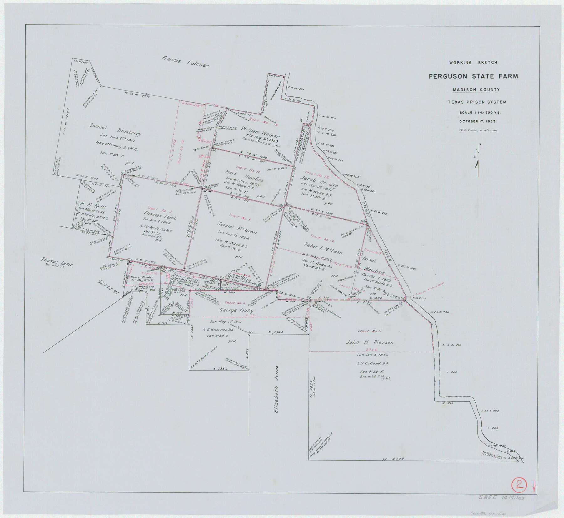
Madison County Working Sketch 2
Ferguson State Farm
-
Map/Doc
70764
-
Collection
General Map Collection
-
Object Dates
10/17/1933 (Creation Date)
-
People and Organizations
W.S. Vines (Draftsman)
-
Counties
Madison
-
Subjects
Surveying Working Sketch
-
Height x Width
23.4 x 25.5 inches
59.4 x 64.8 cm
-
Scale
1" = 500 varas
Part of: General Map Collection

Upton County Rolled Sketch 34

Print $20.00
- Digital $50.00
Upton County Rolled Sketch 34
1951
Size 34.4 x 34.3 inches
Map/Doc 10050
Amistad International Reservoir on Rio Grande 91

Print $20.00
- Digital $50.00
Amistad International Reservoir on Rio Grande 91
1950
Size 28.5 x 41.0 inches
Map/Doc 75521
Flight Mission No. CUG-3P, Frame 42, Kleberg County

Print $20.00
- Digital $50.00
Flight Mission No. CUG-3P, Frame 42, Kleberg County
1956
Size 18.5 x 22.1 inches
Map/Doc 86247
Parker County Sketch File 32

Print $6.00
- Digital $50.00
Parker County Sketch File 32
Size 11.0 x 12.2 inches
Map/Doc 33574
Brazoria County Sketch File 51

Print $380.00
- Digital $50.00
Brazoria County Sketch File 51
1926
Size 14.1 x 7.8 inches
Map/Doc 15125
Preliminary Chart of Entrance to Brazos River, Texas

Print $20.00
- Digital $50.00
Preliminary Chart of Entrance to Brazos River, Texas
1858
Size 18.4 x 19.5 inches
Map/Doc 69973
Real County Working Sketch 21

Print $20.00
- Digital $50.00
Real County Working Sketch 21
1944
Size 24.8 x 35.7 inches
Map/Doc 71913
The Coast of Texas

Print $20.00
- Digital $50.00
The Coast of Texas
1844
Size 18.3 x 26.9 inches
Map/Doc 72697
Map of Palo Pinto County Texas

Print $20.00
- Digital $50.00
Map of Palo Pinto County Texas
1879
Size 22.0 x 17.3 inches
Map/Doc 3933
Kimble County Sketch File 26

Print $4.00
- Digital $50.00
Kimble County Sketch File 26
1912
Size 7.8 x 13.0 inches
Map/Doc 28969
Rockwall County Boundary File 9

Print $8.00
- Digital $50.00
Rockwall County Boundary File 9
Size 15.9 x 9.0 inches
Map/Doc 58433
You may also like
Schönberg's map of Texas.

Print $20.00
Schönberg's map of Texas.
1866
Size 11.0 x 13.0 inches
Map/Doc 93575
Houston County Sketch File 5a

Print $5.00
- Digital $50.00
Houston County Sketch File 5a
Size 8.5 x 9.4 inches
Map/Doc 26758
Houston Ship Channel, Alexander Island to Carpenter Bayou

Print $40.00
- Digital $50.00
Houston Ship Channel, Alexander Island to Carpenter Bayou
1989
Size 35.5 x 49.4 inches
Map/Doc 69916
Block 36, Township 3 North

Print $20.00
- Digital $50.00
Block 36, Township 3 North
Size 12.0 x 15.9 inches
Map/Doc 91289
[School Land Leagues in east part of Bailey County/west part of Lamb County]
![90256, [School Land Leagues in east part of Bailey County/west part of Lamb County], Twichell Survey Records](https://historictexasmaps.com/wmedia_w700/maps/90256-1.tif.jpg)
Print $2.00
- Digital $50.00
[School Land Leagues in east part of Bailey County/west part of Lamb County]
Size 11.8 x 8.9 inches
Map/Doc 90256
The United States of America

Print $20.00
- Digital $50.00
The United States of America
1866
Size 21.3 x 18.3 inches
Map/Doc 72646
Map of Texas in 1836

Print $20.00
- Digital $50.00
Map of Texas in 1836
1936
Size 24.5 x 19.3 inches
Map/Doc 449
Lipscomb County Working Sketch 1

Print $20.00
- Digital $50.00
Lipscomb County Working Sketch 1
1964
Size 30.7 x 34.1 inches
Map/Doc 70577
Bexar County Working Sketch 10

Print $20.00
- Digital $50.00
Bexar County Working Sketch 10
1959
Size 22.6 x 34.5 inches
Map/Doc 67326
Throckmorton County Rolled Sketch 3

Print $20.00
- Digital $50.00
Throckmorton County Rolled Sketch 3
1987
Size 31.2 x 36.3 inches
Map/Doc 7986
Galveston County Sketch File 43

Print $40.00
- Digital $50.00
Galveston County Sketch File 43
1915
Size 19.4 x 15.1 inches
Map/Doc 11539
[3KA and vicinity]
![90846, [3KA and vicinity], Twichell Survey Records](https://historictexasmaps.com/wmedia_w700/maps/90846-2.tif.jpg)
Print $20.00
- Digital $50.00
[3KA and vicinity]
Size 32.9 x 10.3 inches
Map/Doc 90846