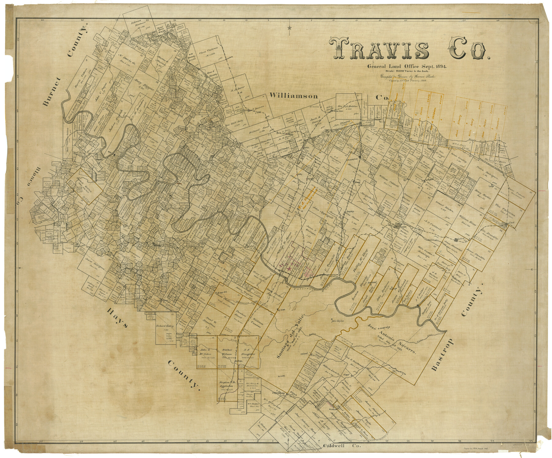
Travis Co.
-
Map/Doc
63074
-
Collection
General Map Collection
-
Object Dates
9/1894 (Creation Date)
-
People and Organizations
Texas General Land Office (Publisher)
Herman Pressler (Compiler)
Herman Pressler (Draftsman)
-
Counties
Travis
-
Subjects
County
-
Height x Width
44.3 x 53.2 inches
112.5 x 135.1 cm
-
Comments
Copied in February 1908 by S. C. Clark.
Part of: General Map Collection
Reeves County Rolled Sketch 13

Print $40.00
- Digital $50.00
Reeves County Rolled Sketch 13
1927
Size 23.6 x 72.2 inches
Map/Doc 9851
Montgomery County Working Sketch 63

Print $20.00
- Digital $50.00
Montgomery County Working Sketch 63
1964
Size 31.6 x 36.7 inches
Map/Doc 71170
Atascosa County Rolled Sketch 5A

Print $20.00
- Digital $50.00
Atascosa County Rolled Sketch 5A
1910
Size 20.8 x 14.4 inches
Map/Doc 5089
Jeff Davis County Working Sketch 31

Print $20.00
- Digital $50.00
Jeff Davis County Working Sketch 31
1969
Size 41.6 x 43.3 inches
Map/Doc 66526
Cameron County Rolled Sketch 25

Print $20.00
- Digital $50.00
Cameron County Rolled Sketch 25
1977
Size 24.8 x 36.8 inches
Map/Doc 5792
Flight Mission No. CRC-6R, Frame 37, Chambers County

Print $20.00
- Digital $50.00
Flight Mission No. CRC-6R, Frame 37, Chambers County
1956
Size 18.5 x 22.4 inches
Map/Doc 84970
Karnes County Boundary File 5a

Print $4.00
- Digital $50.00
Karnes County Boundary File 5a
Size 8.1 x 13.3 inches
Map/Doc 55721
Wichita County Boundary File 2b

Print $4.00
- Digital $50.00
Wichita County Boundary File 2b
Size 8.9 x 8.8 inches
Map/Doc 59911
Jefferson County Rolled Sketch 62

Print $40.00
- Digital $50.00
Jefferson County Rolled Sketch 62
1974
Size 78.4 x 43.1 inches
Map/Doc 9318
Flight Mission No. BQY-4M, Frame 43, Harris County

Print $20.00
- Digital $50.00
Flight Mission No. BQY-4M, Frame 43, Harris County
1953
Size 18.6 x 22.3 inches
Map/Doc 85258
Refugio County Sketch File 19

Print $20.00
- Digital $50.00
Refugio County Sketch File 19
1916
Size 35.0 x 16.1 inches
Map/Doc 12247
Frio County Working Sketch Graphic Index

Print $20.00
- Digital $50.00
Frio County Working Sketch Graphic Index
1944
Size 43.0 x 41.4 inches
Map/Doc 76549
You may also like
Right of Way and Track Map International & Gt. Northern Ry. operated by the International & Gt. Northern Ry. Co., Gulf Division, Columbia Branch

Print $40.00
- Digital $50.00
Right of Way and Track Map International & Gt. Northern Ry. operated by the International & Gt. Northern Ry. Co., Gulf Division, Columbia Branch
1917
Size 25.1 x 57.0 inches
Map/Doc 64600
Martin County Sketch

Print $20.00
- Digital $50.00
Martin County Sketch
1924
Size 14.3 x 17.2 inches
Map/Doc 92269
Flight Mission No. BRE-2P, Frame 7, Nueces County

Print $20.00
- Digital $50.00
Flight Mission No. BRE-2P, Frame 7, Nueces County
1956
Size 18.5 x 22.4 inches
Map/Doc 86716
Trinity River, Barnett Crossing Sheet/Brushy and Kings Creek

Print $20.00
- Digital $50.00
Trinity River, Barnett Crossing Sheet/Brushy and Kings Creek
1927
Size 41.3 x 30.2 inches
Map/Doc 65221
Duval County Sketch File 78

Print $2.00
- Digital $50.00
Duval County Sketch File 78
1984
Size 14.5 x 8.9 inches
Map/Doc 21468
[Southwest Portion of Glasscock County]
![90765, [Southwest Portion of Glasscock County], Twichell Survey Records](https://historictexasmaps.com/wmedia_w700/maps/90765-1.tif.jpg)
Print $20.00
- Digital $50.00
[Southwest Portion of Glasscock County]
Size 18.7 x 20.9 inches
Map/Doc 90765
Sulphur River, Turner Lake Sheet, Cuthand Creek

Print $20.00
- Digital $50.00
Sulphur River, Turner Lake Sheet, Cuthand Creek
1922
Size 28.5 x 34.3 inches
Map/Doc 65157
Stonewall County Sketch File C

Print $20.00
- Digital $50.00
Stonewall County Sketch File C
1886
Size 13.1 x 8.2 inches
Map/Doc 37196
Map of Crockett County

Print $40.00
- Digital $50.00
Map of Crockett County
1878
Size 62.5 x 51.1 inches
Map/Doc 93372
Medina County Boundary File 1

Print $14.00
- Digital $50.00
Medina County Boundary File 1
Size 12.8 x 8.1 inches
Map/Doc 57019
Brazos County Working Sketch 8

Print $20.00
- Digital $50.00
Brazos County Working Sketch 8
1981
Size 18.0 x 13.8 inches
Map/Doc 67483
Map of north end of Brazos Island

Print $20.00
- Digital $50.00
Map of north end of Brazos Island
1845
Size 24.3 x 18.3 inches
Map/Doc 72919