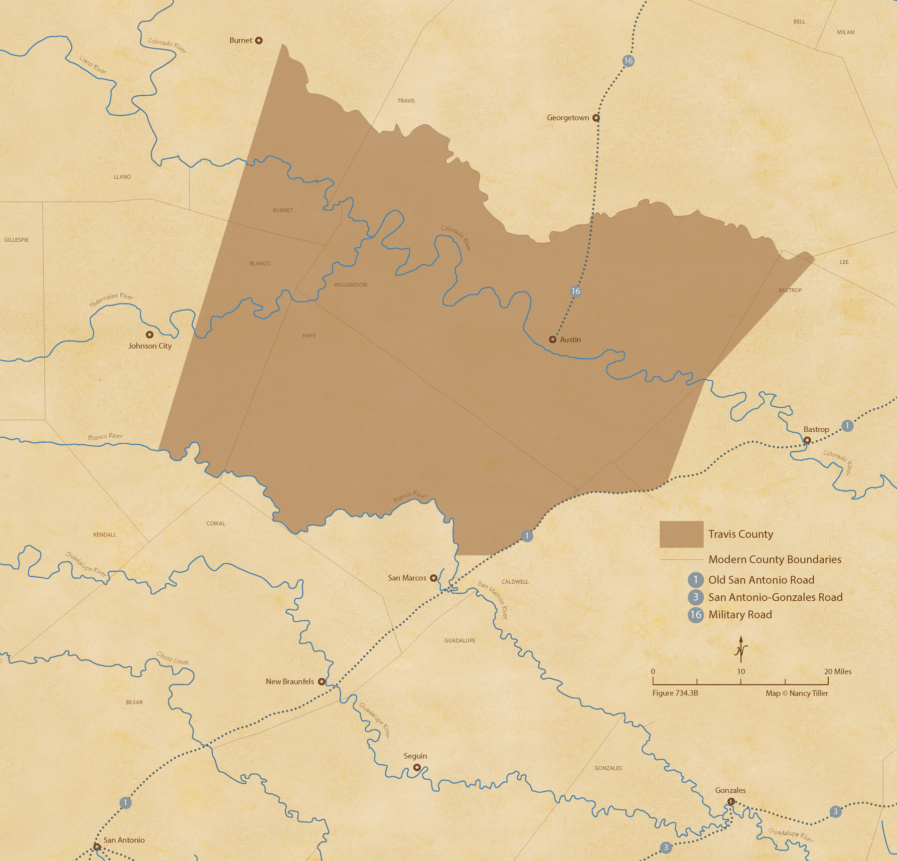
The Republic County of Travis. January 29, 1842
Figure No. 734.3 from 'A Boundary Atlas of Texas, 1821-1845' by Jim Tiller
-
Map/Doc
96291
-
Collection
Nancy and Jim Tiller Digital Collection
-
Object Dates
2020/1/1 (Creation Date)
-
People and Organizations
Jim Tiller (Author)
Nancy Tiller (Cartographer)
Gang Gong (GIS Professional)
-
Counties
Travis
-
Subjects
Atlas County Republic of Texas Texas Boundaries
-
Height x Width
20.8 x 21.6 inches
52.8 x 54.9 cm
-
Medium
digital image
-
Comments
To purchase a digital PDF copy of "A Boundary Atlas of Texas, 1821-1845" see 96437.
Please note that the labels for Williamson and Travis Counties on this map have been transposed in error.
Part of: Nancy and Jim Tiller Digital Collection
The Republic County of Gonzales. Boundaries Defined, December 14, 1837

Print $20.00
The Republic County of Gonzales. Boundaries Defined, December 14, 1837
2020
Size 14.7 x 21.7 inches
Map/Doc 96153
The Republic County of Jefferson. January 20, 1841

Print $20.00
The Republic County of Jefferson. January 20, 1841
2020
Size 22.6 x 21.7 inches
Map/Doc 96198
The Republic County of Colorado. January 1, 1838

Print $20.00
The Republic County of Colorado. January 1, 1838
2020
Size 18.4 x 21.7 inches
Map/Doc 96120
Milam Empresario Colony. January 12, 1826

Print $20.00
Milam Empresario Colony. January 12, 1826
2020
Size 14.2 x 21.8 inches
Map/Doc 96000
The Republic County of Harris. December 29, 1845

Print $20.00
The Republic County of Harris. December 29, 1845
2020
Size 17.7 x 21.7 inches
Map/Doc 96168
The Republic County of Bexar. December 29, 1845

Print $20.00
The Republic County of Bexar. December 29, 1845
2020
Size 24.6 x 21.6 inches
Map/Doc 96101
The Republic County of Harrison. June 24, 1841

Print $20.00
The Republic County of Harrison. June 24, 1841
2020
Size 18.6 x 21.7 inches
Map/Doc 96171
The Chief Justice County of Milam. April 16, 1837

Print $20.00
The Chief Justice County of Milam. April 16, 1837
2020
Size 16.8 x 21.7 inches
Map/Doc 96059
From Citizens of Shelby and Red River Counties Living East of the Sabine River and Southwest of the Sulphur Fork of Red River for the Creation of a New County to be Called Green, March 11, 1837/April 1, 1837

Print $20.00
From Citizens of Shelby and Red River Counties Living East of the Sabine River and Southwest of the Sulphur Fork of Red River for the Creation of a New County to be Called Green, March 11, 1837/April 1, 1837
2020
Size 24.3 x 21.7 inches
Map/Doc 96373
The Republic County of Fort Bend. February 5, 1840

Print $20.00
The Republic County of Fort Bend. February 5, 1840
2020
Size 14.7 x 21.6 inches
Map/Doc 96139
The Republic County of Shelby. January 30, 1841

Print $20.00
The Republic County of Shelby. January 30, 1841
2020
Size 20.0 x 21.7 inches
Map/Doc 96282
The Mexican Municipality of Brazoria. December 28, 1834

Print $20.00
The Mexican Municipality of Brazoria. December 28, 1834
2020
Size 16.5 x 21.7 inches
Map/Doc 96017
You may also like
Flight Mission No. DIX-6P, Frame 202, Aransas County

Print $20.00
- Digital $50.00
Flight Mission No. DIX-6P, Frame 202, Aransas County
1956
Size 19.2 x 22.7 inches
Map/Doc 83864
El Paso County Boundary File 2

Print $28.00
- Digital $50.00
El Paso County Boundary File 2
Size 13.2 x 8.2 inches
Map/Doc 53021
Rio Grande, Brownsville Sheet No. 1

Print $6.00
- Digital $50.00
Rio Grande, Brownsville Sheet No. 1
1924
Size 28.3 x 35.4 inches
Map/Doc 65130
Flight Mission No. DQO-8K, Frame 49, Galveston County

Print $20.00
- Digital $50.00
Flight Mission No. DQO-8K, Frame 49, Galveston County
1952
Size 18.7 x 22.3 inches
Map/Doc 85156
Blanco County Rolled Sketch 7
Print $20.00
- Digital $50.00
Blanco County Rolled Sketch 7
Size 31.0 x 23.8 inches
Map/Doc 5144
Runnels County Working Sketch 17

Print $20.00
- Digital $50.00
Runnels County Working Sketch 17
1950
Size 27.1 x 21.5 inches
Map/Doc 63613
Burnet County Working Sketch 1

Print $20.00
- Digital $50.00
Burnet County Working Sketch 1
1916
Size 22.4 x 31.9 inches
Map/Doc 67844
Kleberg County Boundary File 4a

Print $40.00
- Digital $50.00
Kleberg County Boundary File 4a
Size 23.3 x 62.2 inches
Map/Doc 64997
Nueces County Sketch File 13

Print $20.00
- Digital $50.00
Nueces County Sketch File 13
1940
Size 18.3 x 18.7 inches
Map/Doc 42178
Harrison County Sketch File 3

Print $8.00
- Digital $50.00
Harrison County Sketch File 3
Size 13.0 x 8.3 inches
Map/Doc 26036
Leon County Rolled Sketch 19

Print $20.00
- Digital $50.00
Leon County Rolled Sketch 19
1982
Size 23.9 x 37.4 inches
Map/Doc 6605
Marion County

Print $20.00
- Digital $50.00
Marion County
1943
Size 24.3 x 41.2 inches
Map/Doc 77365