Presidio County Rolled Sketch 104
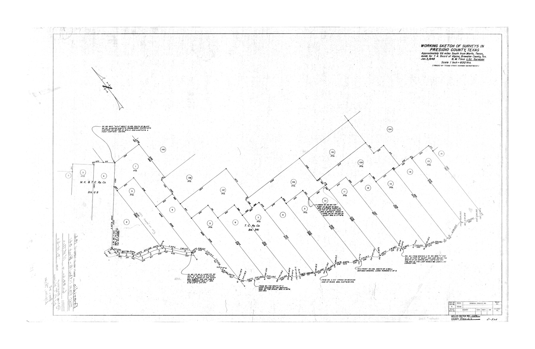
Working sketch of surveys in Presidio County, Texas [showing surveys 1 through 15, Block 341, T. C. Ry. Co. and surroudning areas]
-
Map/Doc
7386
-
Collection
General Map Collection
-
Object Dates
1948/1/3 (Creation Date)
1960/7/22 (File Date)
-
People and Organizations
N.M. Thee (Surveyor/Engineer)
-
Counties
Presidio
-
Subjects
Surveying Rolled Sketch
-
Height x Width
26.1 x 40.0 inches
66.3 x 101.6 cm
-
Scale
1" = 600 varas
Part of: General Map Collection
Limestone County Working Sketch 6

Print $20.00
- Digital $50.00
Limestone County Working Sketch 6
1922
Size 31.5 x 33.3 inches
Map/Doc 70556
Cooke County Sketch File 9

Print $6.00
- Digital $50.00
Cooke County Sketch File 9
Size 8.2 x 10.5 inches
Map/Doc 19237
Flight Mission No. BQR-12K, Frame 47, Brazoria County

Print $20.00
- Digital $50.00
Flight Mission No. BQR-12K, Frame 47, Brazoria County
1952
Size 18.7 x 22.4 inches
Map/Doc 84062
Brewster County Sketch File S-26a

Print $18.00
- Digital $50.00
Brewster County Sketch File S-26a
1964
Size 11.1 x 8.7 inches
Map/Doc 15837
Dallas County Rolled Sketch 6

Print $20.00
- Digital $50.00
Dallas County Rolled Sketch 6
1983
Size 31.7 x 37.5 inches
Map/Doc 8769

Flight Mission No. DQO-2K, Frame 161, Galveston County

Print $20.00
- Digital $50.00
Flight Mission No. DQO-2K, Frame 161, Galveston County
1952
Size 18.7 x 22.4 inches
Map/Doc 85050
Wilson County Boundary File 9

Print $42.00
- Digital $50.00
Wilson County Boundary File 9
Size 14.3 x 8.9 inches
Map/Doc 60119
Blanco County Working Sketch 21

Print $20.00
- Digital $50.00
Blanco County Working Sketch 21
1960
Size 34.1 x 29.2 inches
Map/Doc 67381
National Map Company's Map of Texas showing counties, cities, towns, villages and post offices, steam and electric railways with stations and distance between stations

Print $40.00
- Digital $50.00
National Map Company's Map of Texas showing counties, cities, towns, villages and post offices, steam and electric railways with stations and distance between stations
1920
Size 50.3 x 51.1 inches
Map/Doc 10749
Kendall County Sketch File 22B

Print $20.00
- Digital $50.00
Kendall County Sketch File 22B
1937
Size 19.3 x 24.6 inches
Map/Doc 11911
Lampasas County Rolled Sketch 3

Print $20.00
- Digital $50.00
Lampasas County Rolled Sketch 3
Size 43.8 x 33.9 inches
Map/Doc 9554
You may also like
Cherokee County Working Sketch 22

Print $20.00
- Digital $50.00
Cherokee County Working Sketch 22
1972
Size 24.0 x 19.2 inches
Map/Doc 67977
[B. S. & F. Block 9 and surrounding area]
![93070, [B. S. & F. Block 9 and surrounding area], Twichell Survey Records](https://historictexasmaps.com/wmedia_w700/maps/93070-1.tif.jpg)
Print $20.00
- Digital $50.00
[B. S. & F. Block 9 and surrounding area]
Size 18.3 x 26.1 inches
Map/Doc 93070
Flight Mission No. DIX-6P, Frame 116, Aransas County

Print $20.00
- Digital $50.00
Flight Mission No. DIX-6P, Frame 116, Aransas County
1956
Size 19.2 x 23.1 inches
Map/Doc 83822
Presidio County Sketch File 115

Print $14.00
- Digital $50.00
Presidio County Sketch File 115
1993
Size 11.3 x 8.9 inches
Map/Doc 34835

[Warren Additions 3 and 4 and vicinity]
![92464, [Warren Additions 3 and 4 and vicinity], Twichell Survey Records](https://historictexasmaps.com/wmedia_w700/maps/92464-1.tif.jpg)
Print $20.00
- Digital $50.00
[Warren Additions 3 and 4 and vicinity]
Size 23.9 x 19.5 inches
Map/Doc 92464
Morris County Boundary File 3

Print $6.00
- Digital $50.00
Morris County Boundary File 3
Size 10.8 x 8.1 inches
Map/Doc 57485
Terrell County Rolled Sketch 24

Print $20.00
- Digital $50.00
Terrell County Rolled Sketch 24
Size 19.7 x 25.7 inches
Map/Doc 7931
[Worksheets related to the Wilson Strickland survey and vicinity]
![91265, [Vicinity and related to the Wilson Strickland Survey], Twichell Survey Records](https://historictexasmaps.com/wmedia_w700/maps/91265-1.tif.jpg)
Print $20.00
- Digital $50.00
[Worksheets related to the Wilson Strickland survey and vicinity]
Size 39.0 x 11.6 inches
Map/Doc 91265
General Highway Map, Crosby County, Texas

Print $20.00
- Digital $50.00
General Highway Map, Crosby County, Texas
1950
Size 25.7 x 18.8 inches
Map/Doc 92596
DeWitt County Sketch File 7

Print $2.00
- Digital $50.00
DeWitt County Sketch File 7
1876
Size 11.3 x 9.0 inches
Map/Doc 20817
A Geographically Correct Map of the State of Texas

Print $20.00
- Digital $50.00
A Geographically Correct Map of the State of Texas
1876
Size 20.4 x 21.7 inches
Map/Doc 95361