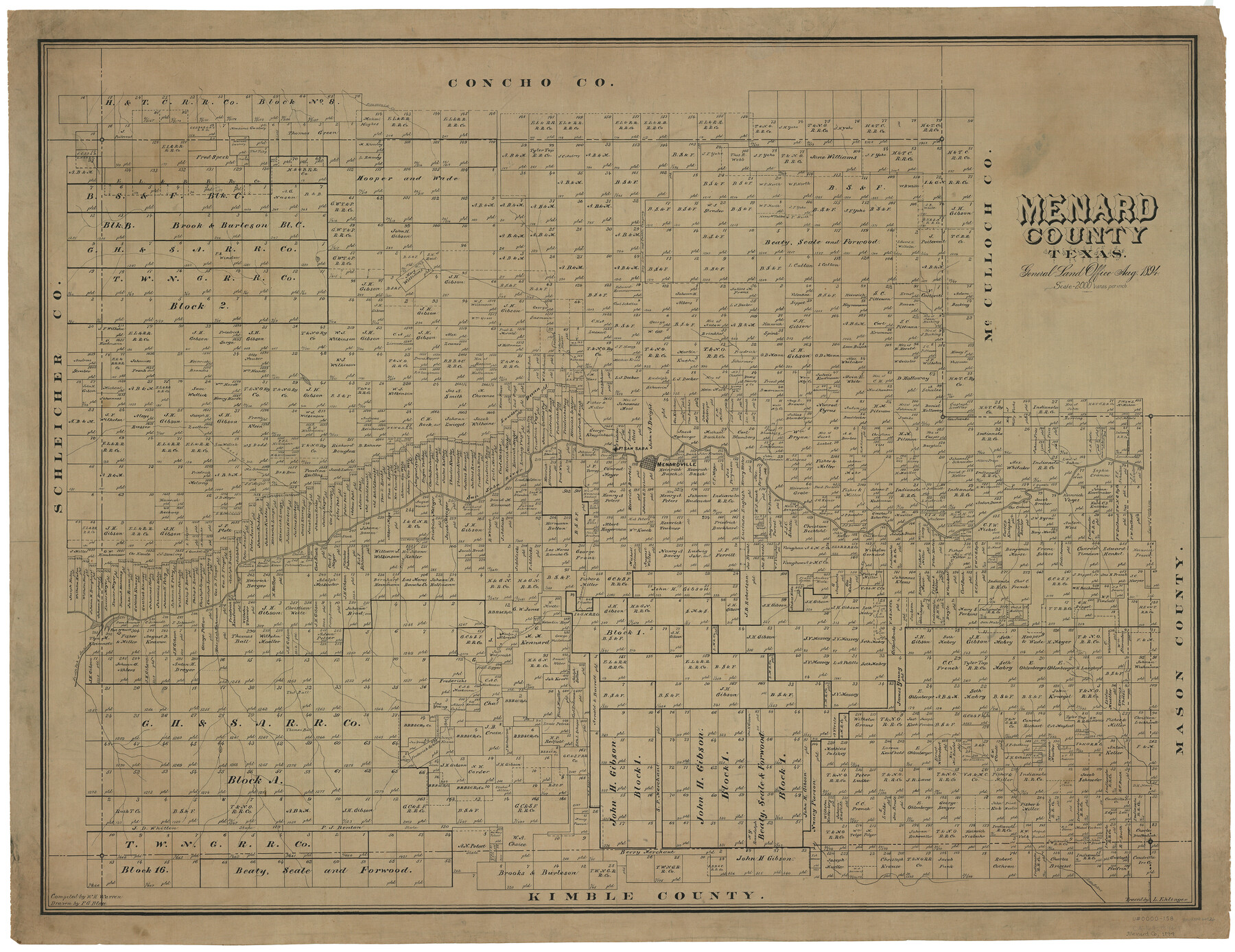
Menard County
-
Map/Doc
66926
-
Collection
General Map Collection
-
Object Dates
8/1894 (Creation Date)
-
People and Organizations
Texas General Land Office (Publisher)
W.H. Warren (Compiler)
F.G. Blau (Draftsman)
-
Counties
Menard
-
Subjects
County
-
Height x Width
32.5 x 42.1 inches
82.6 x 106.9 cm
-
Comments
Traced by L. Ehlinger.
Part of: General Map Collection
Map No. 8-A, Calhoun Co. - Revision of the East portion of Espiritu Santo Bay Tracts

Print $5.00
- Digital $50.00
Map No. 8-A, Calhoun Co. - Revision of the East portion of Espiritu Santo Bay Tracts
1978
Size 21.2 x 28.0 inches
Map/Doc 2498

Jack County Working Sketch 22

Print $20.00
- Digital $50.00
Jack County Working Sketch 22
1995
Size 23.9 x 36.7 inches
Map/Doc 66448
Fractional Township No. 1N and Township No. 2N R. No. 2E, Deaf Smith and Parmer Counties comprising Capitol Leagues 439 and 452 and parts of Capitol Leagues 431, 432, 433, 438, 440, 451, 453, 458, 459, and 460

Print $20.00
- Digital $50.00
Fractional Township No. 1N and Township No. 2N R. No. 2E, Deaf Smith and Parmer Counties comprising Capitol Leagues 439 and 452 and parts of Capitol Leagues 431, 432, 433, 438, 440, 451, 453, 458, 459, and 460
1906
Size 27.1 x 22.4 inches
Map/Doc 93966
Hardeman County Sketch File 3

Print $8.00
- Digital $50.00
Hardeman County Sketch File 3
1880
Size 14.2 x 8.8 inches
Map/Doc 24987
Hutchinson County Sketch File 45

Print $22.00
- Digital $50.00
Hutchinson County Sketch File 45
1991
Size 11.1 x 8.8 inches
Map/Doc 27354
Hutchinson County Sketch File 23

Print $22.00
- Digital $50.00
Hutchinson County Sketch File 23
1913
Size 11.2 x 8.8 inches
Map/Doc 27245
Plat of Resurvey of Sections 4, 9, 10 and 23, T. 5S., R. 13W., of the Indian Meridian, Oklahoma

Print $4.00
- Digital $50.00
Plat of Resurvey of Sections 4, 9, 10 and 23, T. 5S., R. 13W., of the Indian Meridian, Oklahoma
1917
Size 18.0 x 22.6 inches
Map/Doc 75143
Ward County Rolled Sketch A

Print $40.00
- Digital $50.00
Ward County Rolled Sketch A
Size 42.6 x 56.3 inches
Map/Doc 10099
Brazoria County Sketch File 37

Print $40.00
- Digital $50.00
Brazoria County Sketch File 37
1916
Size 20.6 x 30.1 inches
Map/Doc 10959
Kimble County Working Sketch 64

Print $20.00
- Digital $50.00
Kimble County Working Sketch 64
1964
Size 15.1 x 16.9 inches
Map/Doc 70132
Carte du Spits-Berg, et partie de la Côte de Galles hams-kes au nouveau Groenland

Print $20.00
- Digital $50.00
Carte du Spits-Berg, et partie de la Côte de Galles hams-kes au nouveau Groenland
1782
Size 13.8 x 19.8 inches
Map/Doc 97123
You may also like
Map of Africa (Inset: Liberia and Sierra Leone)

Print $20.00
- Digital $50.00
Map of Africa (Inset: Liberia and Sierra Leone)
1844
Size 9.5 x 12.1 inches
Map/Doc 93549
Flight Mission No. CRK-8P, Frame 122, Refugio County

Print $20.00
- Digital $50.00
Flight Mission No. CRK-8P, Frame 122, Refugio County
1956
Size 18.4 x 22.1 inches
Map/Doc 86977
Coleman County Boundary File 17a

Print $84.00
- Digital $50.00
Coleman County Boundary File 17a
Size 17.5 x 17.1 inches
Map/Doc 51663
Blanco County Working Sketch 11

Print $3.00
- Digital $50.00
Blanco County Working Sketch 11
1941
Size 10.8 x 10.4 inches
Map/Doc 67371
Starr County Sketch File 22

Print $20.00
- Digital $50.00
Starr County Sketch File 22
1922
Size 16.4 x 35.9 inches
Map/Doc 12331
Hill County Sketch File 26

Print $12.00
- Digital $50.00
Hill County Sketch File 26
1892
Size 8.9 x 8.5 inches
Map/Doc 26522
General Highway Map, Live Oak County, Texas

Print $20.00
General Highway Map, Live Oak County, Texas
1961
Size 18.3 x 24.8 inches
Map/Doc 79575
Coryell County Working Sketch 1

Print $20.00
- Digital $50.00
Coryell County Working Sketch 1
1906
Size 14.7 x 12.9 inches
Map/Doc 68208
Texas and Pacific Railway and its connections.

Print $20.00
Texas and Pacific Railway and its connections.
1876
Size 17.3 x 34.3 inches
Map/Doc 93601
Knox County Working Sketch 1

Print $20.00
- Digital $50.00
Knox County Working Sketch 1
1899
Size 32.7 x 25.4 inches
Map/Doc 70243
Hidalgo County Working Sketch 5

Print $20.00
- Digital $50.00
Hidalgo County Working Sketch 5
1956
Size 38.1 x 37.9 inches
Map/Doc 66182
Crosby County Sketch File 35

Print $4.00
- Digital $50.00
Crosby County Sketch File 35
Size 8.5 x 12.1 inches
Map/Doc 20106