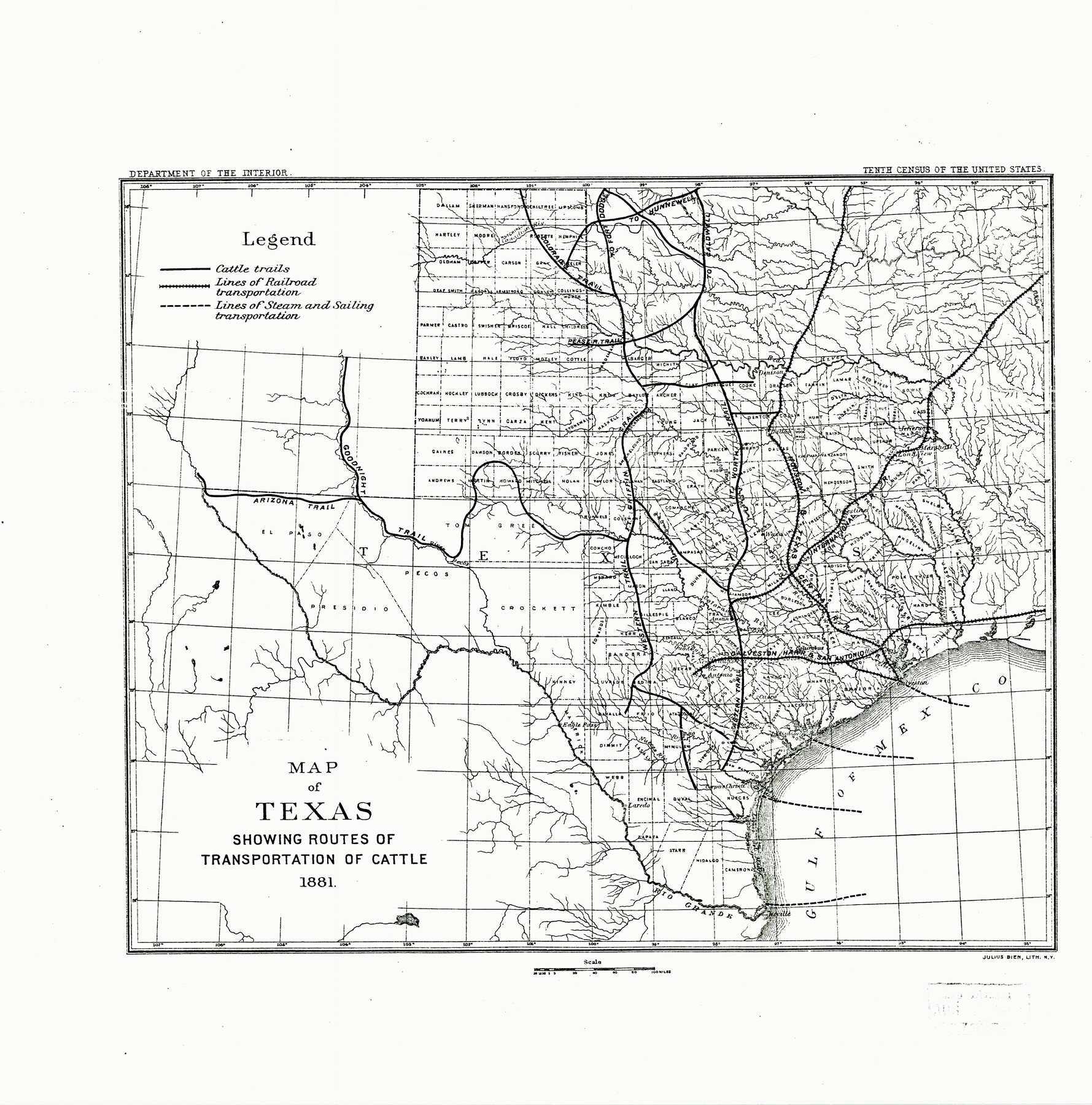
Map of Texas Showing Routes of Transportation of Cattle
-
Map/Doc
95718
-
Collection
Library of Congress
-
Object Dates
1881 (Creation Date)
-
People and Organizations
US Department of the Interior (Publisher)
Julius Bien (Printer)
Julius Bien (Lithographer)
-
Subjects
State of Texas
-
Height x Width
11.0 x 10.9 inches
27.9 x 27.7 cm
-
Medium
digital image
-
Comments
Published for inclusion in a report for the Tenth Census of the United States. Prints available from the GLO courtesy of Library of Congress, Geography and Map Division.
Part of: Library of Congress
Colton's rail road and county map of the southern states containing the latest information.

Print $20.00
Colton's rail road and county map of the southern states containing the latest information.
1864
Size 24.4 x 31.1 inches
Map/Doc 93570

[Map showing T&P Lands in El Paso County]
![88936, [Map showing T&P Lands in El Paso County], Library of Congress](https://historictexasmaps.com/wmedia_w700/maps/88936.tif.jpg)
Print $20.00
[Map showing T&P Lands in El Paso County]
Size 22.6 x 17.5 inches
Map/Doc 88936
Natural provinces : [Texas].
![93576, Natural provinces : [Texas]., Library of Congress](https://historictexasmaps.com/wmedia_w700/maps/93576.tif.jpg)
Print $20.00
Natural provinces : [Texas].
1899
Size 14.2 x 15.4 inches
Map/Doc 93576
A new and complete county map of all the rail roads in the United States & Canadas in operation & progress.

Print $20.00
A new and complete county map of all the rail roads in the United States & Canadas in operation & progress.
1857
Size 19.3 x 22.0 inches
Map/Doc 93606
Map of the River Sabine from its Mouth on the Gulf of Mexico in the Sea to Logan's Ferry in Latitude 31°58'24" north

Print $40.00
Map of the River Sabine from its Mouth on the Gulf of Mexico in the Sea to Logan's Ferry in Latitude 31°58'24" north
1840
Size 35.0 x 170.0 inches
Map/Doc 88901

J. H. Colton's map of the state of Louisiana and eastern part of Texas compiled from United States Surveys, and other authentic sources, showing the counties, townships, sections. Fractional sections, settlement rights, railroads, &c.

Print $20.00
J. H. Colton's map of the state of Louisiana and eastern part of Texas compiled from United States Surveys, and other authentic sources, showing the counties, townships, sections. Fractional sections, settlement rights, railroads, &c.
1863
Size 35.8 x 43.3 inches
Map/Doc 93603
Map of Caldwell County, Texas

Print $20.00
Map of Caldwell County, Texas
1879
Size 17.4 x 21.5 inches
Map/Doc 88914
Map showing the distribution of the slave population of the southern states of the United States. Compiled from the census of 1860

Print $20.00
Map showing the distribution of the slave population of the southern states of the United States. Compiled from the census of 1860
1861
Size 27.8 x 34.8 inches
Map/Doc 95749


You may also like
Bird's Eye View of the City of Dallas, Texas

Print $20.00
Bird's Eye View of the City of Dallas, Texas
1872
Size 18.6 x 25.6 inches
Map/Doc 89080
Map of City of Brownfield, Texas

Print $20.00
- Digital $50.00
Map of City of Brownfield, Texas
1953
Size 44.4 x 40.1 inches
Map/Doc 89890
Flight Mission No. CUG-1P, Frame 44, Kleberg County

Print $20.00
- Digital $50.00
Flight Mission No. CUG-1P, Frame 44, Kleberg County
1956
Size 18.7 x 22.3 inches
Map/Doc 86122
Loving County Working Sketch 23

Print $20.00
- Digital $50.00
Loving County Working Sketch 23
1952
Size 15.1 x 31.5 inches
Map/Doc 70657
Motley County Boundary File 1

Print $46.00
- Digital $50.00
Motley County Boundary File 1
Size 9.0 x 4.1 inches
Map/Doc 57488

State Map of Kansas Showing Productive Geological Formation of Each Oil Field

Print $20.00
- Digital $50.00
State Map of Kansas Showing Productive Geological Formation of Each Oil Field
1937
Size 45.5 x 29.8 inches
Map/Doc 92043
Live Oak County Sketch File 11a

Print $4.00
- Digital $50.00
Live Oak County Sketch File 11a
1876
Size 12.7 x 8.3 inches
Map/Doc 30265
PSL Field Notes for Blocks B14 and B16 in Crane and Ector Counties, Blocks B18 and B20 in Crane and Ward Counties, and Blocks B17, B21, B22, B23, B24, B25, and B26 in Crane County

PSL Field Notes for Blocks B14 and B16 in Crane and Ector Counties, Blocks B18 and B20 in Crane and Ward Counties, and Blocks B17, B21, B22, B23, B24, B25, and B26 in Crane County
Map/Doc 81646
Refugio County Working Sketch 13

Print $20.00
- Digital $50.00
Refugio County Working Sketch 13
1961
Size 23.8 x 29.8 inches
Map/Doc 63522
[G. & M. Block 5]
![91793, [G. & M. Block 5], Twichell Survey Records](https://historictexasmaps.com/wmedia_w700/maps/91793-1.tif.jpg)
Print $20.00
- Digital $50.00
[G. & M. Block 5]
Size 34.9 x 17.2 inches
Map/Doc 91793
Kerr County Working Sketch 14

Print $20.00
- Digital $50.00
Kerr County Working Sketch 14
1952
Size 26.5 x 24.5 inches
Map/Doc 70045