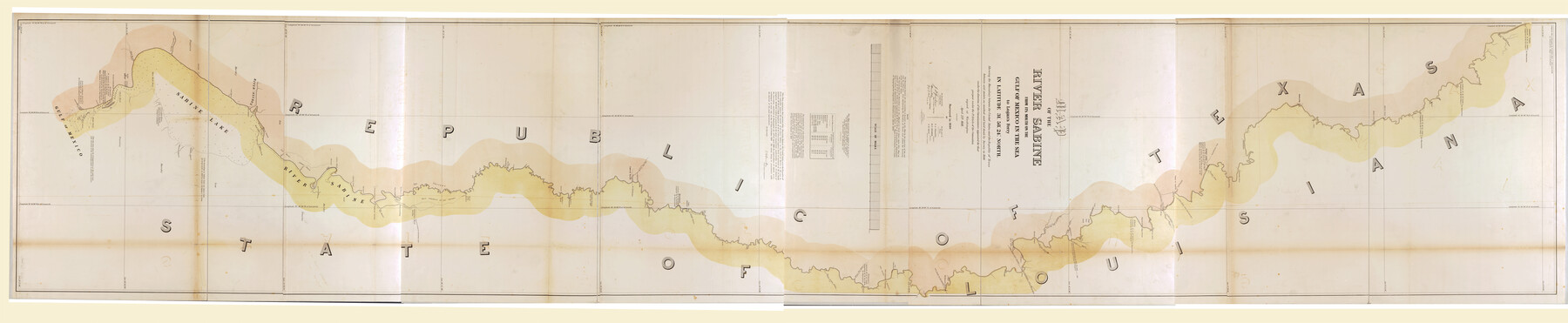
Map of the River Sabine from its Mouth on the Gulf of Mexico in the Sea to Logan's Ferry in Latitude 31°58'24" north
-
Map/Doc
88901
-
Collection
Library of Congress
-
Object Dates
1840 (Creation Date)
-
People and Organizations
US Togographical Engineers (Publisher)
A.B. Gray (Surveyor/Engineer)
George G. Meade (Surveyor/Engineer)
T.J. Lee (Draftsman)
J.D. Graham (Surveyor/Engineer)
T.J. Lee (Surveyor/Engineer)
P.J. Pillans (Surveyor/Engineer)
D.C. Wilber (Surveyor/Engineer)
-
Subjects
River Surveys Texas Boundaries
-
Height x Width
35.0 x 170.0 inches
88.9 x 431.8 cm
-
Comments
For more information see here. Prints available from the GLO courtesy of Library of Congress, Geography and Map Division.
Part of: Library of Congress
Butt's Map of Cooke County, Texas

Print $20.00
Butt's Map of Cooke County, Texas
1888
Size 17.5 x 14.5 inches
Map/Doc 88920
The Santa Fe Route and connections

Print $20.00
The Santa Fe Route and connections
1888
Size 15.4 x 24.8 inches
Map/Doc 96972
Rullmann's map of the city of San Antonio

Print $20.00
Rullmann's map of the city of San Antonio
1890
Size 34.6 x 31.0 inches
Map/Doc 93555
Map of McMullen County

Print $20.00
Map of McMullen County
1879
Size 28.6 x 19.3 inches
Map/Doc 88975
El Nuevo Mexico y Tierras Adyacentes Mapa Levantado para la demarcacion de los Limites de los Dominios Españoles y de los Estados Unidos por el P.D. Jose Pichardo quien lo dedica al Exmo. Sor. D. Fracisco Xavier Venegas Virrey de esta N.E. &. Año de 1811

Print $40.00
El Nuevo Mexico y Tierras Adyacentes Mapa Levantado para la demarcacion de los Limites de los Dominios Españoles y de los Estados Unidos por el P.D. Jose Pichardo quien lo dedica al Exmo. Sor. D. Fracisco Xavier Venegas Virrey de esta N.E. &. Año de 1811
1811
Size 35.8 x 49.6 inches
Map/Doc 95360
Greenville, Tex., County Seat of Hunt County, 1886

Print $20.00
Greenville, Tex., County Seat of Hunt County, 1886
1886
Size 20.4 x 28.3 inches
Map/Doc 93476
Carta General de la República Mexicana formada por Antonio García y Cubas

Print $40.00
Carta General de la República Mexicana formada por Antonio García y Cubas
1863
Size 48.7 x 57.1 inches
Map/Doc 95307
J. H. Colton's map of the state of Louisiana and eastern part of Texas compiled from United States Surveys, and other authentic sources, showing the counties, townships, sections. Fractional sections, settlement rights, railroads, &c.

Print $20.00
J. H. Colton's map of the state of Louisiana and eastern part of Texas compiled from United States Surveys, and other authentic sources, showing the counties, townships, sections. Fractional sections, settlement rights, railroads, &c.
1863
Size 35.8 x 43.3 inches
Map/Doc 93603

Plano del Lago de San Bernardo en el Seno Mexicano

Print $20.00
Plano del Lago de San Bernardo en el Seno Mexicano
1783
Size 17.7 x 13.8 inches
Map/Doc 93615
Map of the southern states, including rail roads, county towns, state capitals, count roads, the southern coast from Delaware to Texas, showing the harbors, inlets, forts and position of blockading ships.

Print $20.00
Map of the southern states, including rail roads, county towns, state capitals, count roads, the southern coast from Delaware to Texas, showing the harbors, inlets, forts and position of blockading ships.
1863
Size 20.1 x 29.9 inches
Map/Doc 93571
J. De Cordova's Map of the State of Texas Compiled from the records of the General Land Office of the State

Print $20.00
J. De Cordova's Map of the State of Texas Compiled from the records of the General Land Office of the State
1853
Size 35.0 x 35.0 inches
Map/Doc 88903
You may also like
Jefferson County Sketch File 42

Print $20.00
- Digital $50.00
Jefferson County Sketch File 42
1945
Size 25.5 x 35.1 inches
Map/Doc 11876
Stephens County Working Sketch 15

Print $20.00
- Digital $50.00
Stephens County Working Sketch 15
1963
Size 35.8 x 36.8 inches
Map/Doc 63958
Brewster County Sketch File S-28

Print $40.00
- Digital $50.00
Brewster County Sketch File S-28
Size 26.1 x 36.7 inches
Map/Doc 10982
Irion County Rolled Sketch 22

Print $20.00
- Digital $50.00
Irion County Rolled Sketch 22
1936
Size 24.3 x 39.9 inches
Map/Doc 6330
Dimmit County Rolled Sketch 20A

Print $20.00
- Digital $50.00
Dimmit County Rolled Sketch 20A
1999
Size 24.9 x 36.5 inches
Map/Doc 6065
Kendall County Working Sketch 20

Print $20.00
- Digital $50.00
Kendall County Working Sketch 20
1970
Size 37.7 x 44.8 inches
Map/Doc 66692
Kerr County Working Sketch 2

Print $20.00
- Digital $50.00
Kerr County Working Sketch 2
1926
Size 18.6 x 17.9 inches
Map/Doc 70033


El Paso County Sketch File 1a

Print $4.00
- Digital $50.00
El Paso County Sketch File 1a
Size 12.1 x 8.2 inches
Map/Doc 21907
[Sketch for Mineral Application 26501 - Sabine River, T. A. Oldhausen]
![2835, [Sketch for Mineral Application 26501 - Sabine River, T. A. Oldhausen], General Map Collection](https://historictexasmaps.com/wmedia_w700/maps/2835.tif.jpg)
Print $20.00
- Digital $50.00
[Sketch for Mineral Application 26501 - Sabine River, T. A. Oldhausen]
1931
Size 24.6 x 36.6 inches
Map/Doc 2835
Collin County Sketch File 8

Print $4.00
- Digital $50.00
Collin County Sketch File 8
1859
Size 10.2 x 8.1 inches
Map/Doc 18868