Liberty County Rolled Sketch OB-1
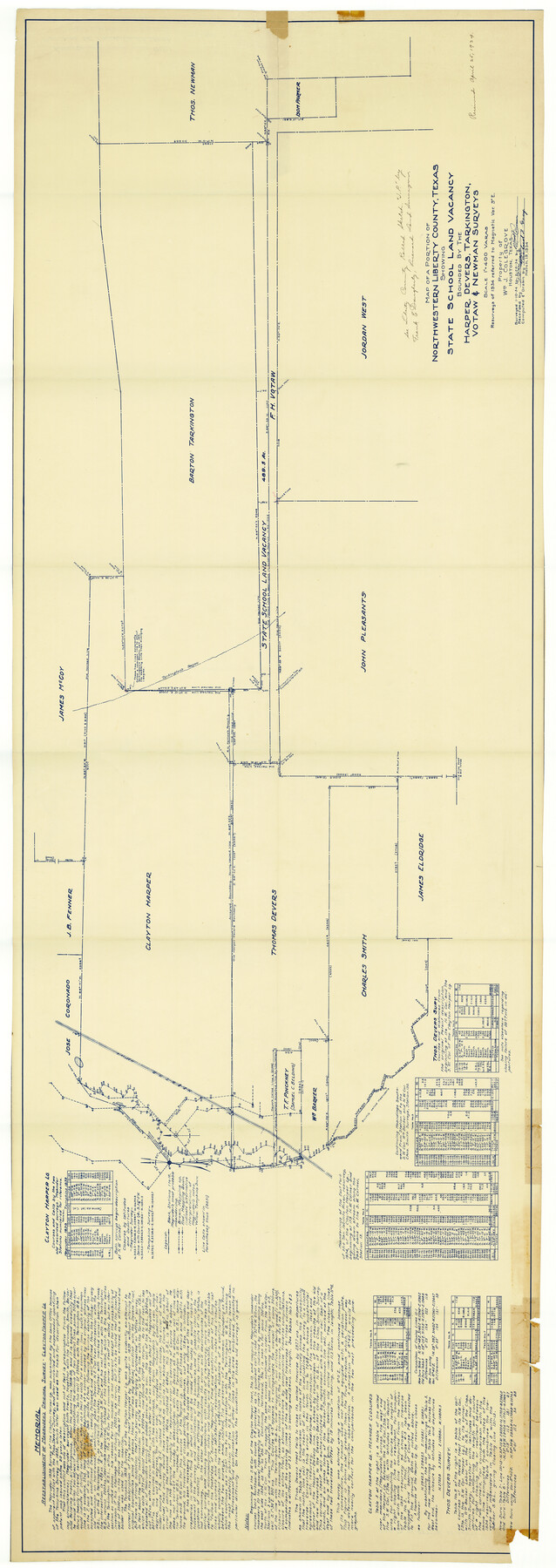
Map of a portion of northwestern Liberty County, Texas showing state School Land vacancy bounded by the Harper, Devers, Tarkington, Votaw, & Newman surveys
-
Map/Doc
9564
-
Collection
General Map Collection
-
Object Dates
1934/3/19 (Creation Date)
1934/4/25 (File Date)
1934/2/20 (Survey Date)
-
People and Organizations
Richard F. Gray (Surveyor/Engineer)
Richard F. Gray (Draftsman)
-
Counties
Liberty
-
Subjects
Surveying Rolled Sketch
-
Height x Width
70.7 x 25.1 inches
179.6 x 63.8 cm
-
Medium
blueprint/diazo
-
Scale
1" = 400 varas
-
Comments
See Liberty County Rolled Sketch OB (9563) for revised sketch.
Related maps
Liberty County Rolled Sketch OB

Print $40.00
- Digital $50.00
Liberty County Rolled Sketch OB
1934
Size 71.0 x 24.8 inches
Map/Doc 9563
Part of: General Map Collection
A Geographically Correct Map of the State of Texas

Print $20.00
- Digital $50.00
A Geographically Correct Map of the State of Texas
1876
Size 20.4 x 21.7 inches
Map/Doc 95361
Red River County Working Sketch 60

Print $20.00
- Digital $50.00
Red River County Working Sketch 60
1973
Size 27.1 x 40.0 inches
Map/Doc 72043
Flight Mission No. DCL-5C, Frame 26, Kenedy County

Print $20.00
- Digital $50.00
Flight Mission No. DCL-5C, Frame 26, Kenedy County
1943
Size 18.5 x 22.3 inches
Map/Doc 85838
Stonewall County Working Sketch 32

Print $20.00
- Digital $50.00
Stonewall County Working Sketch 32
1983
Size 27.9 x 36.2 inches
Map/Doc 62339
Map of Swisher County

Print $20.00
- Digital $50.00
Map of Swisher County
1898
Size 36.4 x 32.7 inches
Map/Doc 16889
Belton and Stillhouse Hollow Reservoirs (Recto)

Belton and Stillhouse Hollow Reservoirs (Recto)
1972
Size 29.1 x 22.6 inches
Map/Doc 94172
Culberson County Rolled Sketch 38A
Print $20.00
- Digital $50.00
Culberson County Rolled Sketch 38A
Size 27.2 x 30.0 inches
Map/Doc 5662
Flight Mission No. BRE-1P, Frame 53, Nueces County

Print $20.00
- Digital $50.00
Flight Mission No. BRE-1P, Frame 53, Nueces County
1956
Size 18.5 x 22.4 inches
Map/Doc 86642
Brazoria County Sketch File 40

Print $8.00
- Digital $50.00
Brazoria County Sketch File 40
1935
Size 14.3 x 8.9 inches
Map/Doc 15049
Concho County Sketch File 42

Print $8.00
- Digital $50.00
Concho County Sketch File 42
1948
Size 14.4 x 8.9 inches
Map/Doc 19200
Hudspeth County Rolled Sketch 66

Print $20.00
- Digital $50.00
Hudspeth County Rolled Sketch 66
1973
Size 12.1 x 18.7 inches
Map/Doc 6261
Gregg County Rolled Sketch 16

Print $20.00
- Digital $50.00
Gregg County Rolled Sketch 16
1942
Size 29.0 x 36.7 inches
Map/Doc 6038
You may also like
[Drawings of individual counties for Pressler and Langermann's 1879 Map of Texas]
![[Drawings of individual counties for Pressler and Langermann's 1879 Map of Texas]](https://historictexasmaps.com/wmedia_w700/maps/4865.tif.jpg)
Print $20.00
- Digital $50.00
[Drawings of individual counties for Pressler and Langermann's 1879 Map of Texas]
1878
Size 27.3 x 38.1 inches
Map/Doc 4865
[Jas. T. Williams Survey and vicinity]
![91263, [Jas. T. Williams Survey and vicinity], Twichell Survey Records](https://historictexasmaps.com/wmedia_w700/maps/91263-1.tif.jpg)
Print $20.00
- Digital $50.00
[Jas. T. Williams Survey and vicinity]
Size 27.0 x 22.1 inches
Map/Doc 91263
Dimmit County Sketch File 60

Print $4.00
- Digital $50.00
Dimmit County Sketch File 60
1991
Size 14.2 x 8.8 inches
Map/Doc 21206
Jim Wells County Boundary File 3

Print $10.00
- Digital $50.00
Jim Wells County Boundary File 3
Size 9.3 x 6.0 inches
Map/Doc 55546
Tarrant County Working Sketch 20

Print $20.00
- Digital $50.00
Tarrant County Working Sketch 20
1999
Size 15.4 x 16.8 inches
Map/Doc 62437

General Highway Map, Runnels County, Texas

Print $20.00
General Highway Map, Runnels County, Texas
1961
Size 24.6 x 18.2 inches
Map/Doc 79642
Kendall County Sketch File 4

Print $4.00
- Digital $50.00
Kendall County Sketch File 4
Size 7.8 x 8.6 inches
Map/Doc 28684
Flight Mission No. CUG-2P, Frame 60, Kleberg County

Print $20.00
- Digital $50.00
Flight Mission No. CUG-2P, Frame 60, Kleberg County
1956
Size 18.4 x 22.3 inches
Map/Doc 86197
Gregg County Rolled Sketch 16
Print $20.00
- Digital $50.00
Gregg County Rolled Sketch 16
1942
Size 29.0 x 36.7 inches
Map/Doc 6038

Sketch of Bull Pasture

Print $3.00
- Digital $50.00
Sketch of Bull Pasture
Size 9.3 x 12.1 inches
Map/Doc 91450