Liberty County Rolled Sketch OB
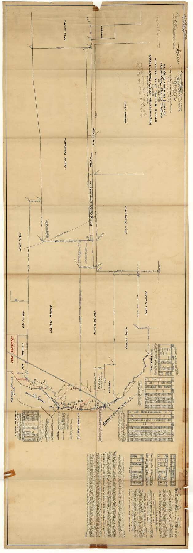
Map of a portion of northwestern Liberty County, Texas showing state School Land vacancy bounded by the Harper, Devers, Tarkington, Votaw, & Newman surveys
-
Map/Doc
9563
-
Collection
General Map Collection
-
Object Dates
1934/4/19 (Revision Date)
1934/5/7 (File Date)
1934/2/20 (Survey Date)
1934/3/19 (Creation Date)
-
People and Organizations
Richard F. Gray (Surveyor/Engineer)
Richard F. Gray (Draftsman)
-
Counties
Liberty
-
Subjects
Surveying Rolled Sketch
-
Height x Width
71.0 x 24.8 inches
180.3 x 63.0 cm
-
Medium
blueprint/diazo
-
Scale
1" = 400 varas
-
Comments
See Liberty County Rolled Sketch OB-1 (9564) for earlier copy of same sketch.
Related maps
Liberty County Rolled Sketch OB-1

Print $40.00
- Digital $50.00
Liberty County Rolled Sketch OB-1
1934
Size 70.7 x 25.1 inches
Map/Doc 9564
Part of: General Map Collection
[Surveys in Burleson County]
![78355, [Surveys in Burleson County], General Map Collection](https://historictexasmaps.com/wmedia_w700/maps/78355.tif.jpg)
Print $20.00
- Digital $50.00
[Surveys in Burleson County]
Size 19.6 x 28.3 inches
Map/Doc 78355
Burleson County Working Sketch 14

Print $20.00
- Digital $50.00
Burleson County Working Sketch 14
1980
Size 24.6 x 18.9 inches
Map/Doc 67733
Map of Hays County

Print $20.00
- Digital $50.00
Map of Hays County
1877
Size 21.2 x 19.8 inches
Map/Doc 3646
Victoria County Sketch File 4

Print $7.00
- Digital $50.00
Victoria County Sketch File 4
1876
Size 10.1 x 8.2 inches
Map/Doc 39517
Crockett County Working Sketch 23

Print $20.00
- Digital $50.00
Crockett County Working Sketch 23
1919
Size 35.1 x 33.7 inches
Map/Doc 68356
Morris County

Print $20.00
- Digital $50.00
Morris County
1906
Size 44.1 x 22.4 inches
Map/Doc 66944
Scurry County Rolled Sketch 5

Print $40.00
- Digital $50.00
Scurry County Rolled Sketch 5
Size 48.4 x 41.1 inches
Map/Doc 9913
Texas City Channel, Texas, Channel and Turning Basin Dredging - Sheet 1

Print $20.00
- Digital $50.00
Texas City Channel, Texas, Channel and Turning Basin Dredging - Sheet 1
1958
Size 29.3 x 40.8 inches
Map/Doc 61831
Menard County Working Sketch 34

Print $20.00
- Digital $50.00
Menard County Working Sketch 34
2003
Size 27.1 x 44.4 inches
Map/Doc 82028
Shelby County Sketch File 15

Print $6.00
- Digital $50.00
Shelby County Sketch File 15
1872
Size 10.2 x 15.5 inches
Map/Doc 36624
Grayson County Sketch File 10

Print $4.00
- Digital $50.00
Grayson County Sketch File 10
1851
Size 12.1 x 7.9 inches
Map/Doc 24474
Zapata County Rolled Sketch 17A

Print $40.00
- Digital $50.00
Zapata County Rolled Sketch 17A
1953
Size 40.6 x 52.2 inches
Map/Doc 10170
You may also like
[Surveying Sketch of Loma Blanca, Santa Rosa, San Antonio del Encinal, et al]
![4449, [Surveying Sketch of Loma Blanca, Santa Rosa, San Antonio del Encinal, et al], Maddox Collection](https://historictexasmaps.com/wmedia_w700/maps/4449.tif.jpg)
Print $20.00
- Digital $50.00
[Surveying Sketch of Loma Blanca, Santa Rosa, San Antonio del Encinal, et al]
Size 19.0 x 22.1 inches
Map/Doc 4449
Fort Bend County Working Sketch 21

Print $20.00
- Digital $50.00
Fort Bend County Working Sketch 21
Size 26.9 x 28.6 inches
Map/Doc 69227
Lampasas County Working Sketch 9

Print $40.00
- Digital $50.00
Lampasas County Working Sketch 9
1963
Size 32.9 x 56.3 inches
Map/Doc 70286
Hall County Sketch File D

Print $8.00
- Digital $50.00
Hall County Sketch File D
1906
Size 14.4 x 8.7 inches
Map/Doc 24792
Real County Sketch File 6

Print $20.00
- Digital $50.00
Real County Sketch File 6
1931
Size 17.3 x 19.6 inches
Map/Doc 12229
Plat of a survey on Padre Island in Willacy County surveyed for South Padre Development Corporation by Settles and Claunch

Print $40.00
- Digital $50.00
Plat of a survey on Padre Island in Willacy County surveyed for South Padre Development Corporation by Settles and Claunch
1966
Size 78.6 x 41.6 inches
Map/Doc 61427
Webb County Working Sketch 21

Print $20.00
- Digital $50.00
Webb County Working Sketch 21
1926
Size 28.7 x 24.7 inches
Map/Doc 72386
Flight Mission No. DQN-1K, Frame 48, Calhoun County

Print $20.00
- Digital $50.00
Flight Mission No. DQN-1K, Frame 48, Calhoun County
1953
Size 17.3 x 18.6 inches
Map/Doc 84148
Webb County Rolled Sketch 57

Print $20.00
- Digital $50.00
Webb County Rolled Sketch 57
Size 23.5 x 32.2 inches
Map/Doc 8209
Edwards County Working Sketch 61

Print $20.00
- Digital $50.00
Edwards County Working Sketch 61
1954
Size 21.0 x 40.3 inches
Map/Doc 68937
Brazoria County Working Sketch 42

Print $20.00
- Digital $50.00
Brazoria County Working Sketch 42
1984
Size 43.5 x 47.1 inches
Map/Doc 67527
Colorado County Sketch File 7

Print $4.00
- Digital $50.00
Colorado County Sketch File 7
1862
Size 13.1 x 8.0 inches
Map/Doc 18925