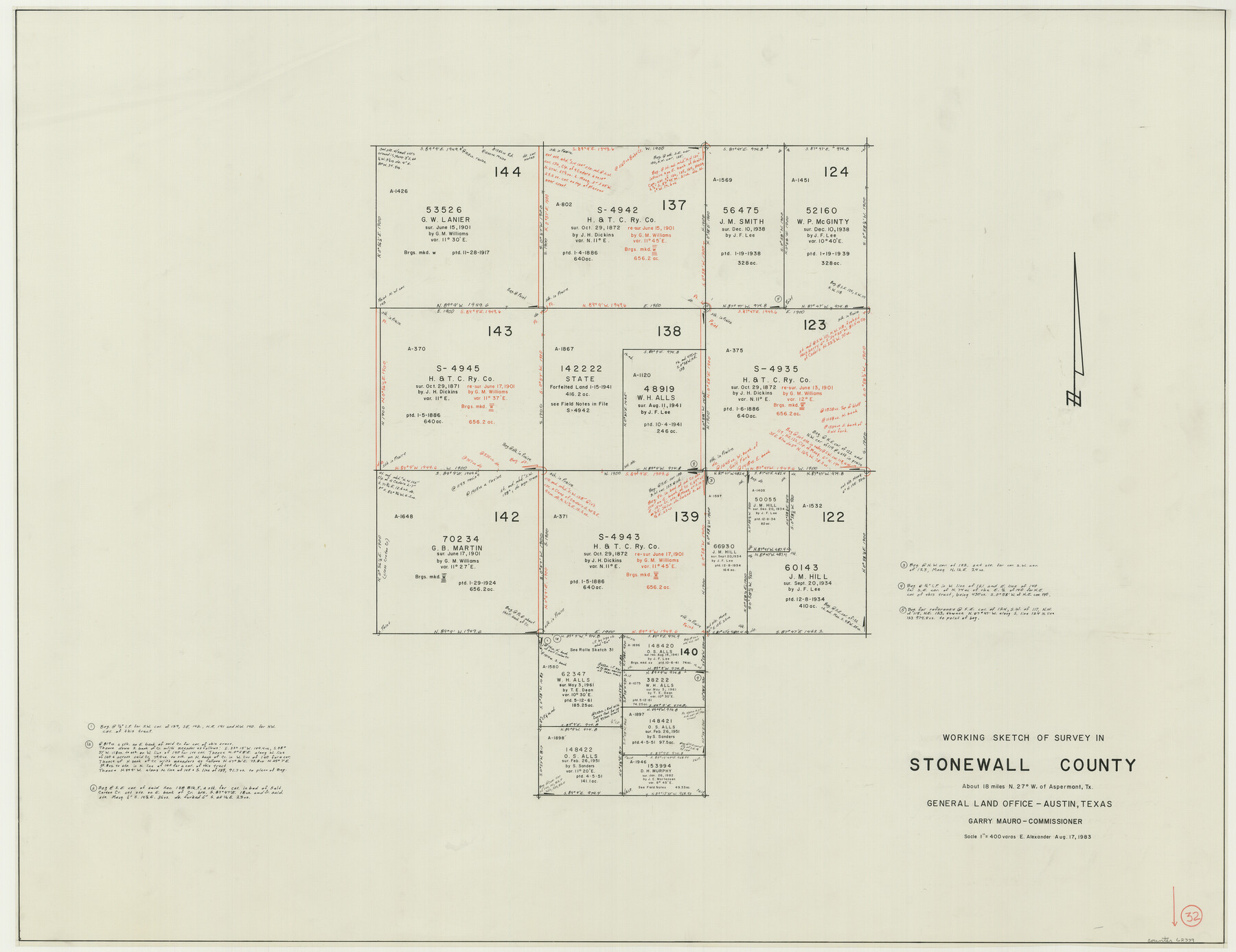
Stonewall County Working Sketch 32
- 
                          Map/Doc
62339
 - 
                            Collection
General Map Collection
 - 
                            Object Dates
8/17/1983 (Creation Date)
 - 
                            People and Organizations
Earl Alexander (Draftsman)
 - 
                            Counties
Stonewall
 - 
                            Subjects
Surveying Working Sketch
 - 
                            Height x Width
27.9 x 36.2 inches
70.9 x 92.0 cm
 - 
                            Scale
1" = 400 varas
 
Part of: General Map Collection
            2008 Official Travel Map Texas


                                                                    Digital $50.00                                    
                2008 Official Travel Map Texas
Size 33.5 x 36.4 inches
                                Map/Doc 94309
            
            Ector County Sketch File 8


                                            Print $20.00                    
                                             -                         Digital $50.00                                    
                Ector County Sketch File 8
1939
Size 40.9 x 24.9 inches
                                Map/Doc 10441
            
            Burnet County Working Sketch Graphic Index


                                            Print $20.00                    
                                             -                         Digital $50.00                                    
                Burnet County Working Sketch Graphic Index
1924
Size 46.5 x 41.2 inches
                                Map/Doc 76482
            
            Erath County Working Sketch 5


                                            Print $20.00                    
                                             -                         Digital $50.00                                    
                Erath County Working Sketch 5
1920
Size 27.6 x 17.1 inches
                                Map/Doc 69086
            
            Colorado River, Brackenridge Tract


                                            Print $20.00                    
                                             -                         Digital $50.00                                    
                Colorado River, Brackenridge Tract
1927
Size 43.6 x 32.1 inches
                                Map/Doc 65325
            
            Hunt County Sketch File 9


                                            Print $3.00                    
                                             -                         Digital $50.00                                    
                Hunt County Sketch File 9
1851
Size 10.0 x 14.8 inches
                                Map/Doc 27099
            
            Martin County Working Sketch 16


                                            Print $20.00                    
                                             -                         Digital $50.00                                    
                Martin County Working Sketch 16
1979
Size 26.6 x 36.8 inches
                                Map/Doc 70834
            
            McMullen County Working Sketch 2


                                            Print $20.00                    
                                             -                         Digital $50.00                                    
                McMullen County Working Sketch 2
1919
Size 30.9 x 19.2 inches
                                Map/Doc 70703
            
            Map of Texas Gulf Coast and Texas Continental Shelf showing Natural Gas Pipe Lines


                                            Print $40.00                    
                                             -                         Digital $50.00                                    
                Map of Texas Gulf Coast and Texas Continental Shelf showing Natural Gas Pipe Lines
1966
Size 39.6 x 57.0 inches
                                Map/Doc 75902
            
            Tyler County Working Sketch 15


                                            Print $20.00                    
                                             -                         Digital $50.00                                    
                Tyler County Working Sketch 15
1960
Size 23.8 x 18.1 inches
                                Map/Doc 69485
            
            Lavaca County Working Sketch 22


                                            Print $20.00                    
                                             -                         Digital $50.00                                    
                Lavaca County Working Sketch 22
1983
Size 39.6 x 36.4 inches
                                Map/Doc 70375
            
            Floyd County Rolled Sketch 10


                                            Print $20.00                    
                                             -                         Digital $50.00                                    
                Floyd County Rolled Sketch 10
1953
Size 37.8 x 25.0 inches
                                Map/Doc 5883
            You may also like
            [E. L. & R. R. RR. Co. Block D8 and vicinity]


                                            Print $20.00                    
                                             -                         Digital $50.00                                    
                [E. L. & R. R. RR. Co. Block D8 and vicinity]
1891
Size 18.5 x 21.0 inches
                                Map/Doc 91863
            
            Polk County Rolled Sketch 20


                                            Print $20.00                    
                                             -                         Digital $50.00                                    
                Polk County Rolled Sketch 20
Size 30.8 x 22.9 inches
                                Map/Doc 7312
            
            Pecos County Rolled Sketch 34


                                            Print $20.00                    
                                             -                         Digital $50.00                                    
                Pecos County Rolled Sketch 34
1891
Size 26.1 x 40.4 inches
                                Map/Doc 7215
            
            Part of the boundary between the United States and Texas: north of Sabine River from the 72nd mile mound to Red River (C.2)


                                            Print $2.00                    
                                             -                         Digital $50.00                                    
                Part of the boundary between the United States and Texas: north of Sabine River from the 72nd mile mound to Red River (C.2)
1842
Size 12.8 x 8.3 inches
                                Map/Doc 65385
            
            Fisher County Rolled Sketch 5


                                            Print $20.00                    
                                             -                         Digital $50.00                                    
                Fisher County Rolled Sketch 5
1961
Size 39.1 x 33.7 inches
                                Map/Doc 8890
            
            Williamson County Sketch File 3


                                            Print $24.00                    
                                             -                         Digital $50.00                                    
                Williamson County Sketch File 3
1853
Size 13.0 x 8.2 inches
                                Map/Doc 40301
            
            Brewster County Sketch File NS-4b


                                            Print $40.00                    
                                             -                         Digital $50.00                                    
                Brewster County Sketch File NS-4b
Size 30.4 x 35.8 inches
                                Map/Doc 10988
            
            Greer County Sketch File 9


                                            Print $6.00                    
                                             -                         Digital $50.00                                    
                Greer County Sketch File 9
Size 15.9 x 11.4 inches
                                Map/Doc 24528
            
            Terrell County Rolled Sketch JAS


                                            Print $40.00                    
                                             -                         Digital $50.00                                    
                Terrell County Rolled Sketch JAS
1936
Size 48.5 x 40.0 inches
                                Map/Doc 9988
            
            Webb County Rolled Sketch 73


                                            Print $20.00                    
                                             -                         Digital $50.00                                    
                Webb County Rolled Sketch 73
1982
Size 33.2 x 17.2 inches
                                Map/Doc 8221
            
            [Surveys along Rabb's Creek]


                                            Print $2.00                    
                                             -                         Digital $50.00                                    
                [Surveys along Rabb's Creek]
1841
Size 8.7 x 11.0 inches
                                Map/Doc 154
            
            Terrell County Working Sketch 38


                                            Print $40.00                    
                                             -                         Digital $50.00                                    
                Terrell County Working Sketch 38
1950
Size 89.1 x 24.9 inches
                                Map/Doc 62131