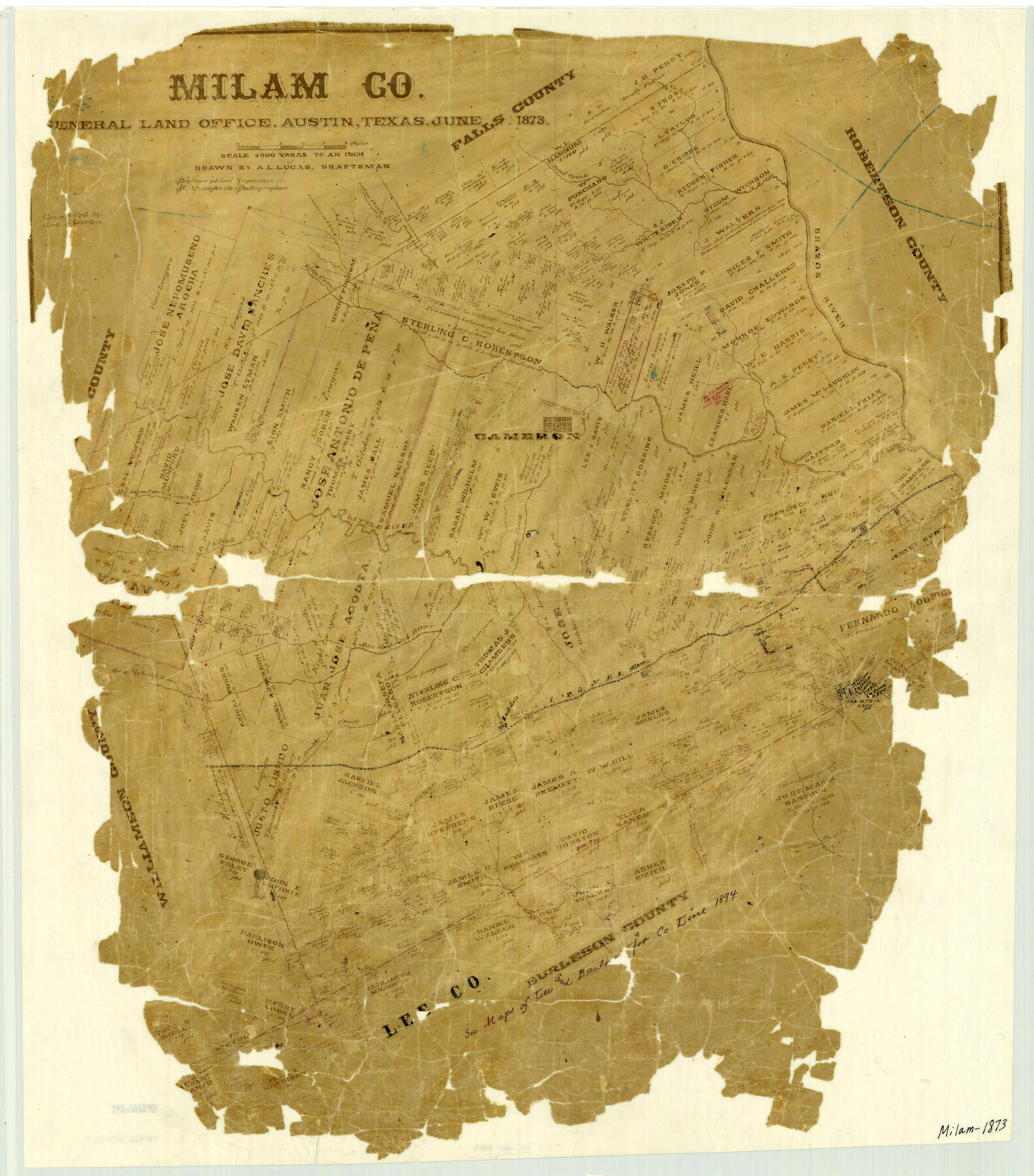
Milam County
-
Map/Doc
3880
-
Collection
General Map Collection
-
Object Dates
1873 (Creation Date)
-
People and Organizations
Texas General Land Office (Publisher)
Herman Lungkwitz (Draftsman)
Joseph Martin (Compiler)
A.L. Lucas (Draftsman)
-
Counties
Milam
-
Subjects
County
-
Height x Width
25.7 x 22.6 inches
65.3 x 57.4 cm
-
Features
Donahoe's Creek
Turkey Creek
Allon Creek
Davidson's Creek
Brushy Creek
Rockdale
I&GN
Milano
Spring Creek
San Gabriel River
Alligator Creek
Clay's Creek
Freeman's Creek
Little River
Sandy Creek
Gause
Jones Creek
Cameron
Elm Creek
Brazos River
Hog Creek
Pond Creek
Indian Creek
Part of: General Map Collection
Flight Mission No. DQO-7K, Frame 109, Galveston County

Print $20.00
- Digital $50.00
Flight Mission No. DQO-7K, Frame 109, Galveston County
1952
Size 18.7 x 22.4 inches
Map/Doc 85124
Hutchinson County Boundary File 4a

Print $40.00
- Digital $50.00
Hutchinson County Boundary File 4a
Size 8.7 x 51.7 inches
Map/Doc 55313

Ochiltree County Working Sketch 1

Print $20.00
- Digital $50.00
Ochiltree County Working Sketch 1
1954
Size 16.7 x 11.6 inches
Map/Doc 71314
Flight Mission No. DCL-7C, Frame 109, Kenedy County

Print $20.00
- Digital $50.00
Flight Mission No. DCL-7C, Frame 109, Kenedy County
1943
Size 18.6 x 22.2 inches
Map/Doc 86074
Hays County Rolled Sketch 20A

Print $20.00
- Digital $50.00
Hays County Rolled Sketch 20A
Size 20.7 x 23.9 inches
Map/Doc 6177
Map of the Galveston, La Porte & Houston Ry. and its Connecting Lines

Print $20.00
- Digital $50.00
Map of the Galveston, La Porte & Houston Ry. and its Connecting Lines
1895
Size 42.6 x 32.0 inches
Map/Doc 64772
Zapata County Sketch File 4

Print $22.00
- Digital $50.00
Zapata County Sketch File 4
1892
Size 14.5 x 17.5 inches
Map/Doc 40906
Runnels County

Print $20.00
- Digital $50.00
Runnels County
1948
Size 46.5 x 36.4 inches
Map/Doc 77411
Chambers County Sketch File B

Print $2.00
- Digital $50.00
Chambers County Sketch File B
1907
Size 7.2 x 8.5 inches
Map/Doc 17515
Hemphill County

Print $20.00
- Digital $50.00
Hemphill County
1899
Size 42.2 x 34.1 inches
Map/Doc 4682
Hudspeth County Rolled Sketch 61

Print $40.00
- Digital $50.00
Hudspeth County Rolled Sketch 61
1982
Size 71.3 x 45.1 inches
Map/Doc 9626
You may also like
Flight Mission No. BRA-16M, Frame 93, Jefferson County

Print $20.00
- Digital $50.00
Flight Mission No. BRA-16M, Frame 93, Jefferson County
1953
Size 18.5 x 22.4 inches
Map/Doc 85705
Flight Mission No. CRK-8P, Frame 117, Refugio County

Print $20.00
- Digital $50.00
Flight Mission No. CRK-8P, Frame 117, Refugio County
1956
Size 18.1 x 22.0 inches
Map/Doc 86972
Map of the L.I.T. Ranche situated in the Panhandle of Texas the property of the Prairie Cattle Co. L'd

Print $20.00
- Digital $50.00
Map of the L.I.T. Ranche situated in the Panhandle of Texas the property of the Prairie Cattle Co. L'd
1989
Size 21.0 x 12.6 inches
Map/Doc 2483
Flight Mission No. CLL-3N, Frame 20, Willacy County

Print $20.00
- Digital $50.00
Flight Mission No. CLL-3N, Frame 20, Willacy County
1954
Size 18.5 x 22.1 inches
Map/Doc 87086
Howard County Sketch File 12

Print $20.00
- Digital $50.00
Howard County Sketch File 12
1939
Size 18.2 x 15.7 inches
Map/Doc 11799
Galveston Bay Entrance - Galveston and Texas City Harbors

Print $40.00
- Digital $50.00
Galveston Bay Entrance - Galveston and Texas City Harbors
Size 38.3 x 54.8 inches
Map/Doc 78271
Flight Mission No. BQY-4M, Frame 35, Harris County

Print $20.00
- Digital $50.00
Flight Mission No. BQY-4M, Frame 35, Harris County
1953
Size 18.7 x 22.5 inches
Map/Doc 85250
Harris County Sketch File 59

Print $32.00
- Digital $50.00
Harris County Sketch File 59
1921
Size 14.3 x 9.0 inches
Map/Doc 25480
Flight Mission No. DQO-6K, Frame 33, Galveston County

Print $20.00
- Digital $50.00
Flight Mission No. DQO-6K, Frame 33, Galveston County
1952
Size 18.8 x 22.4 inches
Map/Doc 85099
Crockett County Rolled Sketch 91

Print $40.00
- Digital $50.00
Crockett County Rolled Sketch 91
1928
Size 26.0 x 63.9 inches
Map/Doc 9033
Flight Mission No. DCL-7C, Frame 115, Kenedy County

Print $20.00
- Digital $50.00
Flight Mission No. DCL-7C, Frame 115, Kenedy County
1943
Size 18.4 x 22.2 inches
Map/Doc 86080
Floyd County Sketch File 23

Print $8.00
- Digital $50.00
Floyd County Sketch File 23
1914
Size 11.6 x 9.0 inches
Map/Doc 22776