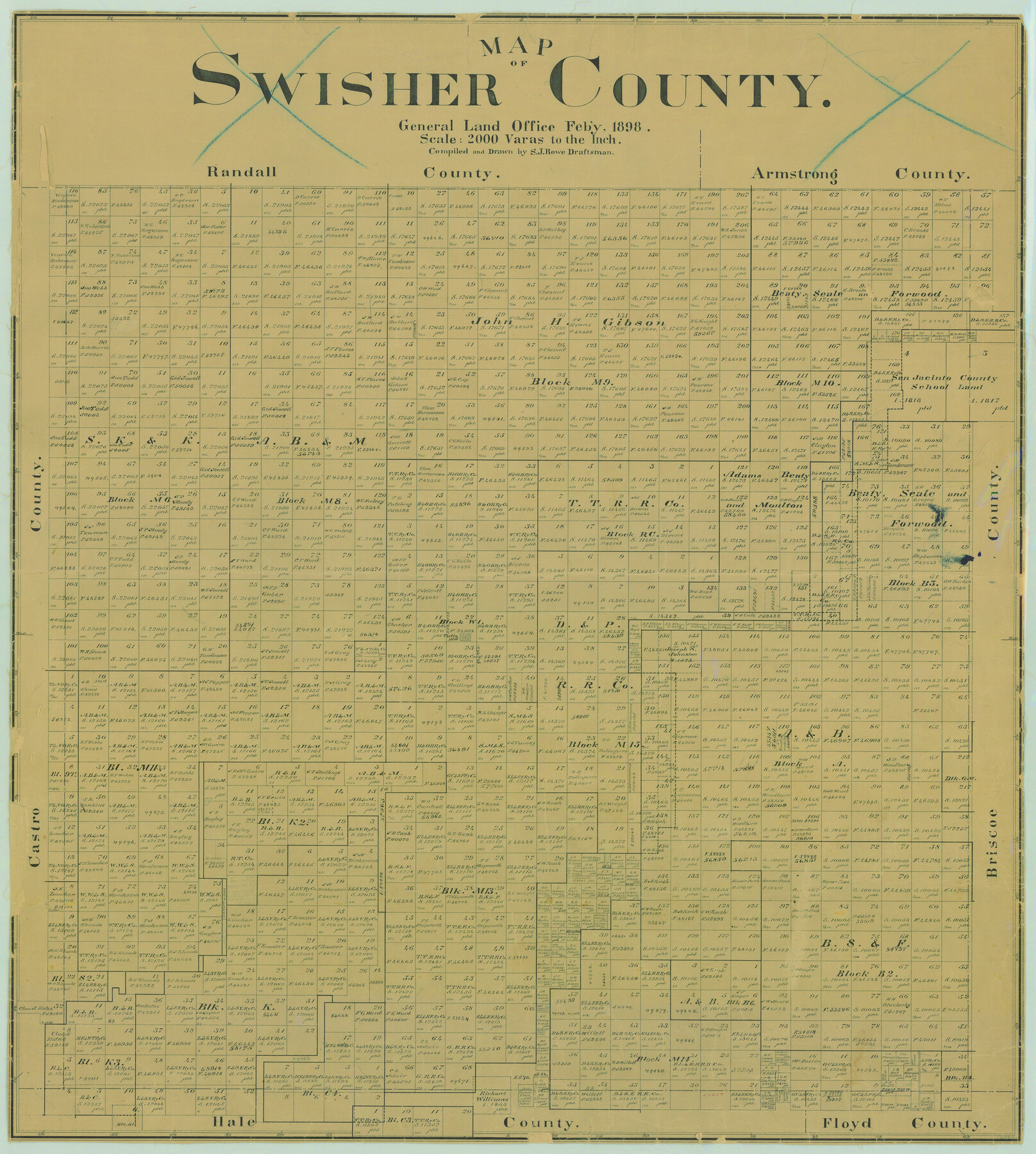
Map of Swisher County
-
Map/Doc
16889
-
Collection
General Map Collection
-
Object Dates
1898 (Creation Date)
-
People and Organizations
Texas General Land Office (Publisher)
Sidney J. Rowe (Compiler)
Sidney J. Rowe (Draftsman)
-
Counties
Swisher
-
Subjects
County
-
Height x Width
36.4 x 32.7 inches
92.5 x 83.1 cm
-
Medium
paper, manuscript
-
Comments
Help Save Texas History - Adopt Me!
-
Features
Tulia
Part of: General Map Collection
Burnet County Working Sketch 16

Print $20.00
- Digital $50.00
Burnet County Working Sketch 16
1979
Size 22.8 x 32.5 inches
Map/Doc 67859
Gaines County

Print $40.00
- Digital $50.00
Gaines County
1902
Size 41.8 x 57.2 inches
Map/Doc 16831
Map of Lipscomb County

Print $20.00
- Digital $50.00
Map of Lipscomb County
1899
Size 43.1 x 39.2 inches
Map/Doc 5017
Current Miscellaneous File 89

Print $4.00
- Digital $50.00
Current Miscellaneous File 89
Size 12.1 x 8.9 inches
Map/Doc 74253
Jefferson County Rolled Sketch 15

Print $147.00
- Digital $50.00
Jefferson County Rolled Sketch 15
1931
Size 10.0 x 15.2 inches
Map/Doc 46298
Matagorda County Sketch File 30

Print $20.00
- Digital $50.00
Matagorda County Sketch File 30
1911
Size 22.2 x 31.9 inches
Map/Doc 12045
Reeves County Working Sketch 55

Print $20.00
- Digital $50.00
Reeves County Working Sketch 55
1978
Size 36.1 x 34.7 inches
Map/Doc 63498
Pecos County Rolled Sketch 19

Print $21.00
- Digital $50.00
Pecos County Rolled Sketch 19
1885
Size 9.4 x 14.7 inches
Map/Doc 48082
Map of a part of Laguna Madre in Willacy & Cameron Counties showing subdivision for mineral development

Print $20.00
- Digital $50.00
Map of a part of Laguna Madre in Willacy & Cameron Counties showing subdivision for mineral development
1950
Size 46.9 x 37.0 inches
Map/Doc 3097
Fisher County Boundary File 3

Print $32.00
- Digital $50.00
Fisher County Boundary File 3
Size 8.2 x 4.2 inches
Map/Doc 53428
Calhoun County Sketch File 4

Print $14.00
- Digital $50.00
Calhoun County Sketch File 4
1908
Size 11.0 x 6.9 inches
Map/Doc 35901
Polk County Sketch File 23A

Print $20.00
- Digital $50.00
Polk County Sketch File 23A
Size 23.4 x 24.3 inches
Map/Doc 12192
You may also like
[Map of Block 97, Borden and Scurry Co (Exhibit A); Map of Southeastern part of Young Territory; Map of part of of Borden, Fisher, Kent, Mitchell, Scurry and Garza Cos. Showing the north boundary line of the T&P 80 mile reservation]
![65692, [Map of Block 97, Borden and Scurry Co (Exhibit A); Map of Southeastern part of Young Territory; Map of part of of Borden, Fisher, Kent, Mitchell, Scurry and Garza Cos. Showing the north boundary line of the T&P 80 mile reservation], General Map Collection](https://historictexasmaps.com/wmedia_w700/maps/65692-1.tif.jpg)
Print $20.00
- Digital $50.00
[Map of Block 97, Borden and Scurry Co (Exhibit A); Map of Southeastern part of Young Territory; Map of part of of Borden, Fisher, Kent, Mitchell, Scurry and Garza Cos. Showing the north boundary line of the T&P 80 mile reservation]
1873
Size 33.4 x 29.6 inches
Map/Doc 65692
Angelina County Working Sketch 52

Print $20.00
- Digital $50.00
Angelina County Working Sketch 52
1978
Size 20.8 x 20.3 inches
Map/Doc 67136
Description of Best Route from Austin to San Antonio, Texas

Print $20.00
Description of Best Route from Austin to San Antonio, Texas
1865
Size 12.9 x 13.1 inches
Map/Doc 79296
Township 2 South Range 12 West, South Western District, Louisiana

Print $20.00
- Digital $50.00
Township 2 South Range 12 West, South Western District, Louisiana
1884
Size 19.7 x 24.7 inches
Map/Doc 65882
Schleicher County Working Sketch 4

Print $20.00
- Digital $50.00
Schleicher County Working Sketch 4
1916
Size 21.0 x 32.6 inches
Map/Doc 63806
[Jack District]
![16828, [Jack District], General Map Collection](https://historictexasmaps.com/wmedia_w700/maps/16828.tif.jpg)
Print $40.00
- Digital $50.00
[Jack District]
1876
Size 50.0 x 76.4 inches
Map/Doc 16828
Flight Mission No. BRE-2P, Frame 70, Nueces County

Print $20.00
- Digital $50.00
Flight Mission No. BRE-2P, Frame 70, Nueces County
1956
Size 18.5 x 22.6 inches
Map/Doc 86765
Archer County Sketch File 15

Print $40.00
- Digital $50.00
Archer County Sketch File 15
1886
Size 16.6 x 17.9 inches
Map/Doc 10827


Map of Brazoria County

Print $20.00
- Digital $50.00
Map of Brazoria County
1883
Size 26.8 x 25.6 inches
Map/Doc 861
Uvalde County Working Sketch 51

Print $20.00
- Digital $50.00
Uvalde County Working Sketch 51
1981
Size 34.7 x 37.7 inches
Map/Doc 72121