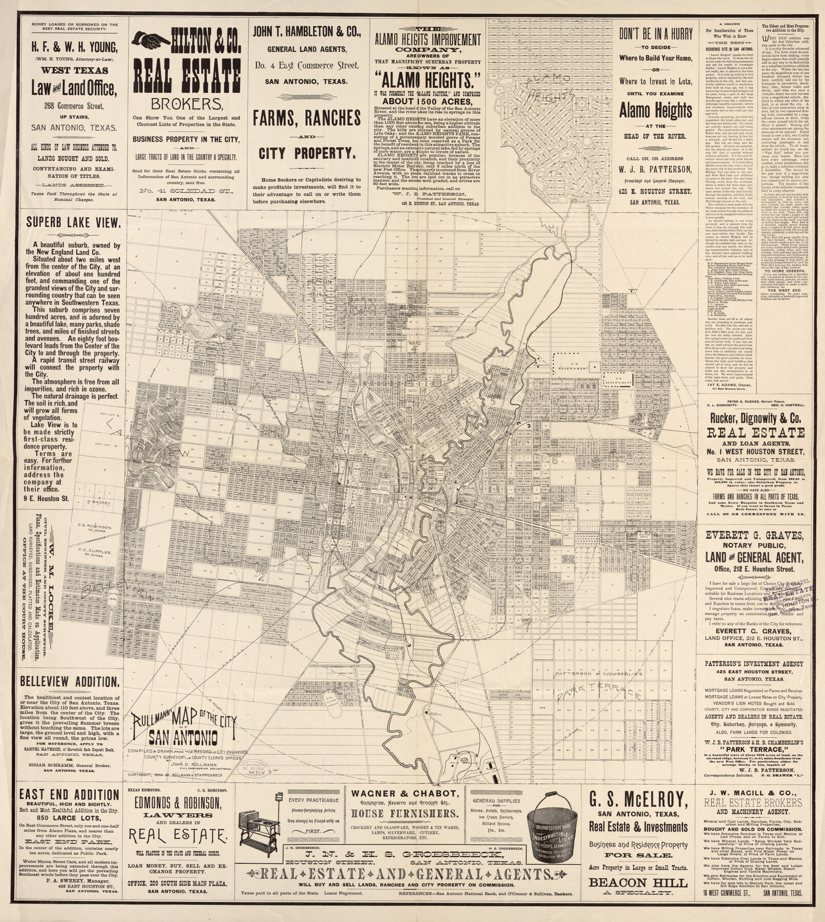
Rullmann's map of the city of San Antonio
-
Map/Doc
93555
-
Collection
Library of Congress
-
Object Dates
1890 (Creation Date)
-
People and Organizations
Rullmann and Stappenbeck (Publisher)
John D. Rullmann (Draftsman)
John D. Rullmann (Compiler)
-
Subjects
City Tejano Genealogical Society - September 26-27, 2025
-
Height x Width
34.6 x 31.0 inches
87.9 x 78.7 cm
-
Comments
For more information see here. Prints available from the GLO courtesy of Library of Congress, Geography and Map Division.
Part of: Library of Congress
Panorama of the seat of war - Birds eye view of Texas and part of Mexico

Print $20.00
Panorama of the seat of war - Birds eye view of Texas and part of Mexico
1861
Size 21.6 x 28.9 inches
Map/Doc 93360
Map of Glasscock County, Texas

Print $20.00
Map of Glasscock County, Texas
Size 22.7 x 18.3 inches
Map/Doc 88943
Palo Pinto County, Texas

Print $20.00
Palo Pinto County, Texas
Size 24.6 x 19.5 inches
Map/Doc 88986
![88958, Jackson Co[unty], Library of Congress](https://historictexasmaps.com/wmedia_w700/maps/88958.tif.jpg)
![88994, San Saba Co[unty], Library of Congress](https://historictexasmaps.com/wmedia_w700/maps/88994-1.tif.jpg)
City of Houston and Environs

Print $20.00
City of Houston and Environs
1895
Size 30.4 x 33.6 inches
Map/Doc 93486
Map of Llano County, Texas

Print $20.00
Map of Llano County, Texas
1879
Size 23.1 x 21.2 inches
Map/Doc 88970
Neue Karte de Staates Texas für 1881.

Print $20.00
Neue Karte de Staates Texas für 1881.
1881
Size 19.3 x 25.6 inches
Map/Doc 93573

[Map showing T&P Lands in El Paso County]
![88935, [Map showing T&P Lands in El Paso County], Library of Congress](https://historictexasmaps.com/wmedia_w700/maps/88935.tif.jpg)
Print $20.00
[Map showing T&P Lands in El Paso County]
Size 22.2 x 17.4 inches
Map/Doc 88935
[Map showing T&P Lands in El Paso County]
![88934, [Map showing T&P Lands in El Paso County], Library of Congress](https://historictexasmaps.com/wmedia_w700/maps/88934.tif.jpg)
Print $20.00
[Map showing T&P Lands in El Paso County]
Size 17.3 x 22.2 inches
Map/Doc 88934
![88982, Motley Co[unty], Library of Congress](https://historictexasmaps.com/wmedia_w700/maps/88982.tif.jpg)
You may also like
Navarro County Sketch File 18

Print $3.00
- Digital $50.00
Navarro County Sketch File 18
1871
Size 10.6 x 10.0 inches
Map/Doc 32335

Harris County Working Sketch 38

Print $20.00
- Digital $50.00
Harris County Working Sketch 38
1938
Size 23.6 x 23.7 inches
Map/Doc 65930
Cameron County Rolled Sketch 25

Print $20.00
- Digital $50.00
Cameron County Rolled Sketch 25
1977
Size 24.9 x 36.7 inches
Map/Doc 5794
St. Louis, Brownsville & Mexico Railway Location Map from Mile 120 to Rio Grande
Print $40.00
- Digital $50.00
St. Louis, Brownsville & Mexico Railway Location Map from Mile 120 to Rio Grande
1905
Size 20.2 x 61.4 inches
Map/Doc 64169
Souvenir - Opening and Dedication of the General Oil Company's New West Texas Oil Field

Souvenir - Opening and Dedication of the General Oil Company's New West Texas Oil Field
1920
Map/Doc 97263
Moore County Sketch File 11

Print $20.00
- Digital $50.00
Moore County Sketch File 11
Size 18.2 x 31.3 inches
Map/Doc 42129
Runnels County Sketch File 40

Print $20.00
Runnels County Sketch File 40
1891
Size 37.7 x 14.3 inches
Map/Doc 10594
Montgomery County Working Sketch 48

Print $20.00
- Digital $50.00
Montgomery County Working Sketch 48
1958
Size 24.4 x 32.1 inches
Map/Doc 71155

Winkler County Sketch File 18

Print $8.00
- Digital $50.00
Winkler County Sketch File 18
1999
Size 11.2 x 8.7 inches
Map/Doc 40517
V. P. Hadsell's Subdivision of Southwest Quarter Section 27, Block D5

Print $20.00
- Digital $50.00
V. P. Hadsell's Subdivision of Southwest Quarter Section 27, Block D5
Size 18.4 x 20.0 inches
Map/Doc 92868