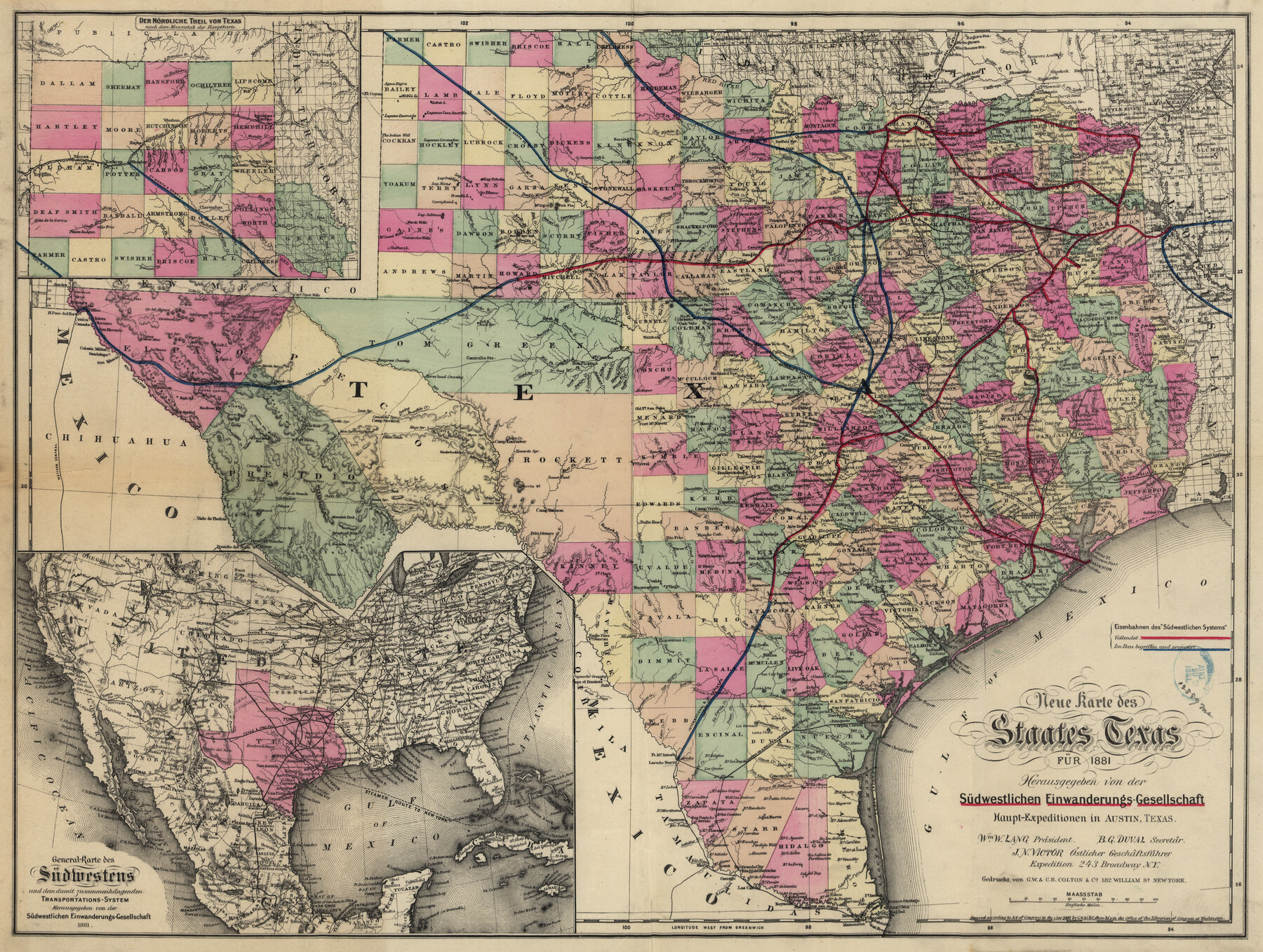
Neue Karte de Staates Texas für 1881.
New Map of Texas for 1881
-
Map/Doc
93573
-
Collection
Library of Congress
-
Object Dates
1881 (Creation Date)
-
People and Organizations
G.W. & C.B. Colton & Co. (Publisher)
-
Subjects
State of Texas
-
Height x Width
19.3 x 25.6 inches
49.0 x 65.0 cm
-
Comments
For more information see here. Prints available from the GLO courtesy of Library of Congress, Geography and Map Division.
Part of: Library of Congress

Map showing the distribution of the slave population of the southern states of the United States. Compiled from the census of 1860

Print $20.00
Map showing the distribution of the slave population of the southern states of the United States. Compiled from the census of 1860
1861
Size 27.8 x 34.8 inches
Map/Doc 95749
Butt's Map of Cooke County, Texas

Print $20.00
Butt's Map of Cooke County, Texas
1888
Size 17.5 x 14.5 inches
Map/Doc 88920
Plano del Lago de Sn. Bernardo situado en la costa del N. del Seno Mexicano su entrada en la L. N. de 28° 24' y en la Long. de 278° 27' segun el Meridiano de Tenerife

Print $20.00
Plano del Lago de Sn. Bernardo situado en la costa del N. del Seno Mexicano su entrada en la L. N. de 28° 24' y en la Long. de 278° 27' segun el Meridiano de Tenerife
Size 7.9 x 17.3 inches
Map/Doc 93616
[Map showing T&P Lands in El Paso County]
![88933, [Map showing T&P Lands in El Paso County], Library of Congress](https://historictexasmaps.com/wmedia_w700/maps/88933.tif.jpg)
Print $20.00
[Map showing T&P Lands in El Paso County]
Size 17.2 x 22.1 inches
Map/Doc 88933
Map of Texas, showing the line of the Texas and New Orleans Rail Road, and its connections in the U.S. and adjacent territories.

Print $20.00
Map of Texas, showing the line of the Texas and New Orleans Rail Road, and its connections in the U.S. and adjacent territories.
1860
Size 22.0 x 31.1 inches
Map/Doc 93612
Bird's Eye View of El Paso

Print $20.00
Bird's Eye View of El Paso
1885
Size 20.0 x 30.0 inches
Map/Doc 93621
Sketch of Texas with the boundaries of Mexican States as shown on General Austin's map of Texas

Print $20.00
Sketch of Texas with the boundaries of Mexican States as shown on General Austin's map of Texas
1839
Size 20.9 x 16.1 inches
Map/Doc 93574
Colton's new map of the state of Texas, the Indian Territory and adjoining portions of New Mexico, Louisiana, and Arkansas

Print $20.00
Colton's new map of the state of Texas, the Indian Territory and adjoining portions of New Mexico, Louisiana, and Arkansas
1872
Size 31.1 x 36.6 inches
Map/Doc 93579
![88910, Bosque Co[unty], Library of Congress](https://historictexasmaps.com/wmedia_w700/maps/88910.tif.jpg)


You may also like
Jones County Boundary File 1

Print $78.00
- Digital $50.00
Jones County Boundary File 1
1882
Size 10.7 x 8.2 inches
Map/Doc 55633
Sherman County Sketch File 6

Print $2.00
- Digital $50.00
Sherman County Sketch File 6
1993
Size 14.6 x 9.1 inches
Map/Doc 36724
The Republic County of Robertson. Spring 1842

Print $20.00
The Republic County of Robertson. Spring 1842
2020
Size 16.9 x 21.7 inches
Map/Doc 96263
Flight Mission No. CGI-1N, Frame 220, Cameron County

Print $20.00
- Digital $50.00
Flight Mission No. CGI-1N, Frame 220, Cameron County
1955
Size 18.5 x 22.1 inches
Map/Doc 84529
Bee County Working Sketch 16

Print $20.00
- Digital $50.00
Bee County Working Sketch 16
1974
Size 18.0 x 19.6 inches
Map/Doc 67266
Wilson County Working Sketch 13

Print $40.00
- Digital $50.00
Wilson County Working Sketch 13
1985
Size 23.9 x 53.5 inches
Map/Doc 72593
Pecos County Sketch showing location of oil wells within 1/2 mile radius of the south 8 acres of the Bob Reid survey

Print $20.00
- Digital $50.00
Pecos County Sketch showing location of oil wells within 1/2 mile radius of the south 8 acres of the Bob Reid survey
Size 18.4 x 16.5 inches
Map/Doc 91639
Clay County Rolled Sketch 2

Print $20.00
- Digital $50.00
Clay County Rolled Sketch 2
1940
Size 35.9 x 26.8 inches
Map/Doc 5485
San Patricio County Sketch File 20

Print $14.00
San Patricio County Sketch File 20
1868
Size 9.2 x 8.5 inches
Map/Doc 36069
E. L. & R. R. RR., Cass Co.

Print $40.00
- Digital $50.00
E. L. & R. R. RR., Cass Co.
1898
Size 13.4 x 65.4 inches
Map/Doc 64244
Flight Mission No. DAG-21K, Frame 34, Matagorda County

Print $20.00
- Digital $50.00
Flight Mission No. DAG-21K, Frame 34, Matagorda County
1952
Size 18.7 x 22.3 inches
Map/Doc 86401
Leon County Sketch File 7

Print $6.00
- Digital $50.00
Leon County Sketch File 7
1858
Size 12.4 x 8.2 inches
Map/Doc 29721