Catalogue of the Spanish Collection of the Texas General Land Office

Price $15.00
Catalogue of the Spanish Collection of the Texas General Land Office
2003
Size: 10.8 x 8.5 inches
83386
New Guide to Spanish and Mexican Land Grants in South Texas

Price $15.00
New Guide to Spanish and Mexican Land Grants in South Texas
2009
Size: 11.0 x 8.5 inches
83388
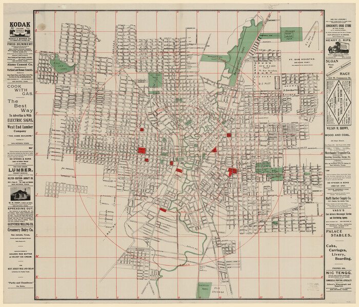
[Map of San Antonio, Texas]
Print $20.00
- Digital $50.00
[Map of San Antonio, Texas]
1895
Size: 29.4 x 34.5 inches
93399
Rullmann's map of the city of San Antonio

Print $20.00
Rullmann's map of the city of San Antonio
1890
Size: 34.6 x 31.0 inches
93555
Map of Texas and the Countries Adjacent compiled in the Bureau of the Corps of Topographical Engineers from the Best Authorities

Print $20.00
- Digital $50.00
Map of Texas and the Countries Adjacent compiled in the Bureau of the Corps of Topographical Engineers from the Best Authorities
1844
Size: 22.3 x 33.4 inches
93867
A Correct Map of the Seat of War in Mexico Being a Copy of Genl Arista's Map, taken at Resaca de la Palma, with additions and Corrections

Print $20.00
- Digital $50.00
A Correct Map of the Seat of War in Mexico Being a Copy of Genl Arista's Map, taken at Resaca de la Palma, with additions and Corrections
1847
Size: 30.7 x 22.5 inches
93962
The Compass Rose of Austin's Colony

Price $20.00
The Compass Rose of Austin's Colony
2016
Size: 4.0 x 3.5 inches
94443
Plano General de la Ciudad de Mexico. Levantado Por el Teniente Coronel Don Diego Garcia Conde en el Año de 1793. Aumentado y corregido en lo mas notable Por el Teniente Coronel retirado, Don Rafael Maria Calvo En el de 1830

Print $20.00
- Digital $50.00
Plano General de la Ciudad de Mexico. Levantado Por el Teniente Coronel Don Diego Garcia Conde en el Año de 1793. Aumentado y corregido en lo mas notable Por el Teniente Coronel retirado, Don Rafael Maria Calvo En el de 1830
1793
Size: 19.7 x 21.8 inches
95354
Perspective Map of the City of Laredo

Print $20.00
- Digital $50.00
Perspective Map of the City of Laredo
1892
Size: 24.2 x 36.3 inches
97096
Catalogue of the Spanish Collection of the Texas General Land Office
Print $15.00
Catalogue of the Spanish Collection of the Texas General Land Office
2003
This catalogue covers the Spanish and Mexican land grants issued north of the Nueces River in what...
-
Size
10.8 x 8.5 inches
-
Map/Doc
83386
-
Creation Date
2003
New Guide to Spanish and Mexican Land Grants in South Texas
Print $15.00
New Guide to Spanish and Mexican Land Grants in South Texas
2009
Featuring 363 expanded entries about Spanish and Mexican land grants in South Texas, this work is...
-
Size
11.0 x 8.5 inches
-
Map/Doc
83388
-
Creation Date
2009
[Map of San Antonio, Texas]
Print $20.00
- Digital $50.00
[Map of San Antonio, Texas]
1895
-
Size
29.4 x 34.5 inches
-
Map/Doc
93399
-
Creation Date
1895
Rullmann's map of the city of San Antonio
Print $20.00
Rullmann's map of the city of San Antonio
1890
-
Size
34.6 x 31.0 inches
-
Map/Doc
93555
-
Creation Date
1890
Map of Texas and the Countries Adjacent compiled in the Bureau of the Corps of Topographical Engineers from the Best Authorities
Print $20.00
- Digital $50.00
Map of Texas and the Countries Adjacent compiled in the Bureau of the Corps of Topographical Engineers from the Best Authorities
1844
-
Size
22.3 x 33.4 inches
-
Map/Doc
93867
-
Creation Date
1844
A Correct Map of the Seat of War in Mexico Being a Copy of Genl Arista's Map, taken at Resaca de la Palma, with additions and Corrections
Print $20.00
- Digital $50.00
A Correct Map of the Seat of War in Mexico Being a Copy of Genl Arista's Map, taken at Resaca de la Palma, with additions and Corrections
1847
-
Size
30.7 x 22.5 inches
-
Map/Doc
93962
-
Creation Date
1847
The Compass Rose of Austin's Colony
Print $20.00
The Compass Rose of Austin's Colony
2016
The Compass Rose of Austin’s Colony is the first ornament produced by the Texas General Land...
-
Size
4.0 x 3.5 inches
-
Map/Doc
94443
-
Creation Date
2016
Plano General de la Ciudad de Mexico. Levantado Por el Teniente Coronel Don Diego Garcia Conde en el Año de 1793. Aumentado y corregido en lo mas notable Por el Teniente Coronel retirado, Don Rafael Maria Calvo En el de 1830
Print $20.00
- Digital $50.00
Plano General de la Ciudad de Mexico. Levantado Por el Teniente Coronel Don Diego Garcia Conde en el Año de 1793. Aumentado y corregido en lo mas notable Por el Teniente Coronel retirado, Don Rafael Maria Calvo En el de 1830
1793
-
Size
19.7 x 21.8 inches
-
Map/Doc
95354
-
Creation Date
1793
Perspective Map of the City of Laredo
Print $20.00
- Digital $50.00
Perspective Map of the City of Laredo
1892
-
Size
24.2 x 36.3 inches
-
Map/Doc
97096
-
Creation Date
1892
The Texas Longhorn

Print $20.00
The Texas Longhorn
2024
Appearing on an 1873 map that the Kansas Pacific Railway Co. produced during the height of the Texas...
-
Size
3.0 x 3.2 inches
-
Map/Doc
97344
-
Creation Date
2024