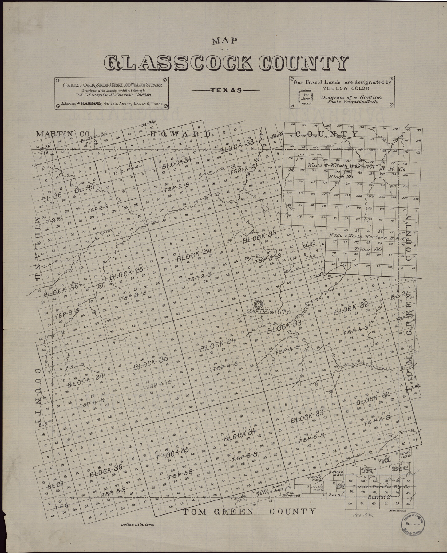
Map of Glasscock County, Texas
-
Map/Doc
88943
-
Collection
Library of Congress
-
People and Organizations
C. J. Canda, S. J. Drake, and W. Strauss (Publisher)
Dallas Lithograph Company (Printer)
M. Stakemann (Draftsman)
-
Counties
Glasscock
-
Subjects
County
-
Height x Width
22.7 x 18.3 inches
57.7 x 46.5 cm
-
Comments
Prints available from the GLO courtesy of Library of Congress, Geography and Map Division.
Part of: Library of Congress
Map of the southern states, including rail roads, county towns, state capitals, count roads, the southern coast from Delaware to Texas, showing the harbors, inlets, forts and position of blockading ships.

Print $20.00
Map of the southern states, including rail roads, county towns, state capitals, count roads, the southern coast from Delaware to Texas, showing the harbors, inlets, forts and position of blockading ships.
1863
Size 20.1 x 29.9 inches
Map/Doc 93571

[Map of T&P Blocks 1 and 2 in Jeff Davis and Presidio Counties]
![88959, [Map of T&P Blocks 1 and 2 in Jeff Davis and Presidio Counties], Library of Congress](https://historictexasmaps.com/wmedia_w700/maps/88959.tif.jpg)
Print $20.00
[Map of T&P Blocks 1 and 2 in Jeff Davis and Presidio Counties]
Size 22.2 x 17.3 inches
Map/Doc 88959
Map exhibiting the fixed location of the main trunk of the New-Orleans, Opelousas & Great Western Railroad of Louisiana…

Print $20.00
Map exhibiting the fixed location of the main trunk of the New-Orleans, Opelousas & Great Western Railroad of Louisiana…
1859
Size 25.2 x 37.0 inches
Map/Doc 93582
Plano del Lago de Sn. Bernardo situado en la costa del N. del Seno Mexicano su entrada en la L. N. de 28° 24' y en la Long. de 278° 27' segun el Meridiano de Tenerife

Print $20.00
Plano del Lago de Sn. Bernardo situado en la costa del N. del Seno Mexicano su entrada en la L. N. de 28° 24' y en la Long. de 278° 27' segun el Meridiano de Tenerife
Size 7.9 x 17.3 inches
Map/Doc 93616
Nelson & White's Official Map of Beaumont

Print $40.00
Nelson & White's Official Map of Beaumont
1902
Size 54.3 x 39.4 inches
Map/Doc 93558

Map of the County of Galveston

Print $20.00
Map of the County of Galveston
1902
Size 18.5 x 26.4 inches
Map/Doc 93584
Map of Caldwell County, Texas

Print $20.00
Map of Caldwell County, Texas
1879
Size 17.4 x 21.5 inches
Map/Doc 88914
Map of the River Sabine from Logan's Ferry to 32nd Degree of North Latitude

Print $20.00
Map of the River Sabine from Logan's Ferry to 32nd Degree of North Latitude
1841
Size 21.4 x 27.8 inches
Map/Doc 88902
City of Houston and Environs

Print $20.00
City of Houston and Environs
1895
Size 30.4 x 33.6 inches
Map/Doc 93486
Map of Caldwell County, Texas

Print $20.00
Map of Caldwell County, Texas
1880
Size 18.7 x 22.0 inches
Map/Doc 88915
You may also like
Newton County Rolled Sketch 3

Print $40.00
- Digital $50.00
Newton County Rolled Sketch 3
Size 69.5 x 32.0 inches
Map/Doc 9574
Castro County Sketch File 4i

Print $4.00
- Digital $50.00
Castro County Sketch File 4i
Size 13.6 x 8.9 inches
Map/Doc 17481
T. & N. O. R.R. Jefferson Co. North

Print $20.00
- Digital $50.00
T. & N. O. R.R. Jefferson Co. North
1917
Size 13.5 x 33.2 inches
Map/Doc 64057
Hartley County Sketch File 3

Print $20.00
- Digital $50.00
Hartley County Sketch File 3
1883
Size 26.8 x 38.4 inches
Map/Doc 10489
Missouri, Kansas, & Texas Ry.

Print $20.00
- Digital $50.00
Missouri, Kansas, & Texas Ry.
Size 6.7 x 5.4 inches
Map/Doc 96598
Sutton County Rolled Sketch 69

Print $20.00
- Digital $50.00
Sutton County Rolled Sketch 69
Size 39.7 x 36.6 inches
Map/Doc 9981

Flight Mission No. CGI-1N, Frame 175, Cameron County

Print $20.00
- Digital $50.00
Flight Mission No. CGI-1N, Frame 175, Cameron County
1955
Size 18.7 x 22.2 inches
Map/Doc 84510
Brown County Working Sketch 5

Print $20.00
- Digital $50.00
Brown County Working Sketch 5
1939
Size 20.9 x 24.0 inches
Map/Doc 67770
McLennan County Boundary File 1

Print $80.00
- Digital $50.00
McLennan County Boundary File 1
Size 19.4 x 12.3 inches
Map/Doc 56937

Brewster County Rolled Sketch 60

Print $40.00
- Digital $50.00
Brewster County Rolled Sketch 60
1942
Size 42.9 x 48.0 inches
Map/Doc 16960