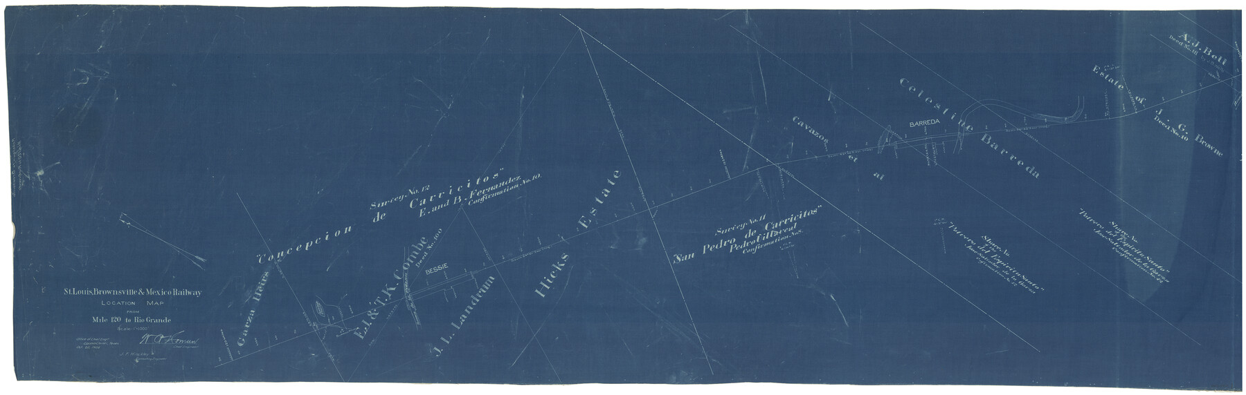
St. Louis, Brownsville & Mexico Railway Location Map from Mile 120 to Rio Grande
Z-2-47
-
Map/Doc
64169
-
Collection
General Map Collection
-
Object Dates
10/20/1905 (Creation Date)
-
People and Organizations
W.O. Homan (Surveyor/Engineer)
J.F. Hinckley (Surveyor/Engineer)
-
Counties
Cameron
-
Subjects
Railroads
-
Height x Width
20.2 x 61.4 inches
51.3 x 156.0 cm
-
Medium
blueprint/diazo
-
Scale
1" = 1000'
-
Comments
See counters 64165 through 64170 for all sheets.
-
Features
Burros Ranch
San Jose Charco
Resaca de los Fresnos
Bessie
Barreda
Part of: General Map Collection
Flight Mission No. BRE-1P, Frame 67, Nueces County

Print $20.00
- Digital $50.00
Flight Mission No. BRE-1P, Frame 67, Nueces County
1956
Size 18.7 x 22.4 inches
Map/Doc 86649
Galveston County Sketch File 71

Print $59.00
- Digital $50.00
Galveston County Sketch File 71
1994
Size 11.0 x 17.0 inches
Map/Doc 23941
[Maps of surveys in Reeves & Culberson Cos]
![61134, [Maps of surveys in Reeves & Culberson Cos], General Map Collection](https://historictexasmaps.com/wmedia_w700/maps/61134.tif.jpg)
Print $20.00
- Digital $50.00
[Maps of surveys in Reeves & Culberson Cos]
1937
Size 30.7 x 24.9 inches
Map/Doc 61134
Lynn County Rolled Sketch 13

Print $20.00
- Digital $50.00
Lynn County Rolled Sketch 13
1926
Size 18.6 x 24.4 inches
Map/Doc 6650
Hutchinson County Rolled Sketch 44-2

Print $20.00
- Digital $50.00
Hutchinson County Rolled Sketch 44-2
2002
Size 24.0 x 36.0 inches
Map/Doc 77538
Map of Crockett County

Print $40.00
- Digital $50.00
Map of Crockett County
1878
Size 62.5 x 51.1 inches
Map/Doc 93372
Flight Mission No. DCL-5C, Frame 78, Kenedy County

Print $20.00
- Digital $50.00
Flight Mission No. DCL-5C, Frame 78, Kenedy County
1943
Size 18.7 x 22.5 inches
Map/Doc 85861
Cherokee County Working Sketch 27

Print $40.00
- Digital $50.00
Cherokee County Working Sketch 27
1982
Size 42.9 x 59.1 inches
Map/Doc 67982
Flight Mission No. DQO-2K, Frame 160, Galveston County

Print $20.00
- Digital $50.00
Flight Mission No. DQO-2K, Frame 160, Galveston County
1952
Size 18.7 x 22.4 inches
Map/Doc 85049
Cameron County Rolled Sketch 7A

Print $20.00
- Digital $50.00
Cameron County Rolled Sketch 7A
1926
Size 30.2 x 34.0 inches
Map/Doc 5384
Menard County Working Sketch 24

Print $20.00
- Digital $50.00
Menard County Working Sketch 24
1950
Size 38.1 x 22.6 inches
Map/Doc 70971
Houston County Sketch File 14

Print $6.00
- Digital $50.00
Houston County Sketch File 14
1886
Size 8.8 x 13.0 inches
Map/Doc 26778
You may also like
Gordon Addition to Idalou

Print $20.00
- Digital $50.00
Gordon Addition to Idalou
1954
Size 22.6 x 10.8 inches
Map/Doc 92827
Map of Cherokee County

Print $20.00
- Digital $50.00
Map of Cherokee County
1863
Size 25.5 x 17.7 inches
Map/Doc 3387
Dimmit County Working Sketch 36

Print $20.00
- Digital $50.00
Dimmit County Working Sketch 36
1962
Size 28.0 x 40.7 inches
Map/Doc 68697
Duval County Rolled Sketch 26
Print $20.00
- Digital $50.00
Duval County Rolled Sketch 26
1945
Size 21.2 x 20.0 inches
Map/Doc 5744
Galveston County NRC Article 33.136 Sketch 75

Print $32.00
- Digital $50.00
Galveston County NRC Article 33.136 Sketch 75
2014
Size 24.0 x 36.0 inches
Map/Doc 95118
Real County Rolled Sketch 12

Print $40.00
- Digital $50.00
Real County Rolled Sketch 12
Size 42.7 x 54.6 inches
Map/Doc 9836
Map of the City of Galveston Situated on the East end of Galveston Island

Print $20.00
- Digital $50.00
Map of the City of Galveston Situated on the East end of Galveston Island
1838
Size 22.0 x 38.1 inches
Map/Doc 2170
Cameron County Rolled Sketch US2

Print $168.00
- Digital $50.00
Cameron County Rolled Sketch US2
1913
Size 10.4 x 16.3 inches
Map/Doc 43804
Greater Texas and the Coast Country - The Winter Garden

Greater Texas and the Coast Country - The Winter Garden
1911
Size 9.4 x 4.5 inches
Map/Doc 97057
Edwards County Working Sketch 110

Print $40.00
- Digital $50.00
Edwards County Working Sketch 110
1972
Size 49.7 x 39.6 inches
Map/Doc 68986
La Salle County Working Sketch 4

Print $20.00
- Digital $50.00
La Salle County Working Sketch 4
1915
Size 31.6 x 36.6 inches
Map/Doc 70305
Flight Mission No. CRC-3R, Frame 10, Chambers County

Print $20.00
- Digital $50.00
Flight Mission No. CRC-3R, Frame 10, Chambers County
1956
Size 18.5 x 22.2 inches
Map/Doc 84784