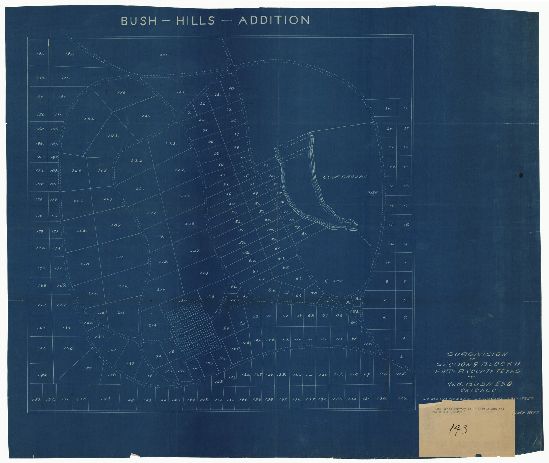
Bush-Hills-Addition, Subdivision of Section 9, Block 11 for W. H. Bush, Esq. Chicago
-
Map/Doc
92110
-
Collection
Twichell Survey Records
-
People and Organizations
H.T. Meinersmann (Draftsman)
-
Counties
Potter
-
Height x Width
19.1 x 16.1 inches
48.5 x 40.9 cm
Part of: Twichell Survey Records
[H. & T. C. RR. Company, Block 47 and vicinity]
![91159, [H. & T. C. RR. Company, Block 47 and vicinity], Twichell Survey Records](https://historictexasmaps.com/wmedia_w700/maps/91159-1.tif.jpg)
Print $20.00
- Digital $50.00
[H. & T. C. RR. Company, Block 47 and vicinity]
Size 18.7 x 19.9 inches
Map/Doc 91159
Enoch's Land Situated in Bailey and Cochran Counties, Texas

Print $20.00
- Digital $50.00
Enoch's Land Situated in Bailey and Cochran Counties, Texas
1925
Size 29.1 x 35.7 inches
Map/Doc 92515
[Texas Boundary Line]
![92081, [Texas Boundary Line], Twichell Survey Records](https://historictexasmaps.com/wmedia_w700/maps/92081-1.tif.jpg)
Print $20.00
- Digital $50.00
[Texas Boundary Line]
Size 21.2 x 12.4 inches
Map/Doc 92081
Sketch Showing Division Fence Shelton- Matador, Oldham County

Print $20.00
- Digital $50.00
Sketch Showing Division Fence Shelton- Matador, Oldham County
Size 21.6 x 24.4 inches
Map/Doc 91484
Leila Y. Post Montgomery & Marjorie Post Hutton's Subdivision of Hall County School Land Leagues 158-159-N 1/2 157, Cochran County, Texas

Print $20.00
- Digital $50.00
Leila Y. Post Montgomery & Marjorie Post Hutton's Subdivision of Hall County School Land Leagues 158-159-N 1/2 157, Cochran County, Texas
Size 8.4 x 18.4 inches
Map/Doc 90456
[Blocks B12 and 6T]
![91514, [Blocks B12 and 6T], Twichell Survey Records](https://historictexasmaps.com/wmedia_w700/maps/91514-1.tif.jpg)
Print $2.00
- Digital $50.00
[Blocks B12 and 6T]
Size 14.6 x 9.1 inches
Map/Doc 91514
Northeastern United States Including the Great Lakes Region

Northeastern United States Including the Great Lakes Region
1959
Size 25.6 x 19.3 inches
Map/Doc 92395
Eberstadt and Brock's Subdivisions of the West Half of Survey 187 Block 2 A. B. & M., Randall County Texas

Print $20.00
- Digital $50.00
Eberstadt and Brock's Subdivisions of the West Half of Survey 187 Block 2 A. B. & M., Randall County Texas
Size 17.7 x 29.6 inches
Map/Doc 91748
[Sketch showing Jeff Davis County, Blocks 1, 2, 3, 4, 360, 363 and JG1]
![91776, [Sketch showing Jeff Davis County, Blocks 1, 2, 3, 4, 360, 363 and JG1], Twichell Survey Records](https://historictexasmaps.com/wmedia_w700/maps/91776-1.tif.jpg)
Print $20.00
- Digital $50.00
[Sketch showing Jeff Davis County, Blocks 1, 2, 3, 4, 360, 363 and JG1]
Size 20.5 x 13.7 inches
Map/Doc 91776
Ownership Map Midland Co., Texas

Ownership Map Midland Co., Texas
1951
Size 43.2 x 45.3 inches
Map/Doc 89914
Sketch in Crockett County, Texas

Print $20.00
- Digital $50.00
Sketch in Crockett County, Texas
Size 27.8 x 23.4 inches
Map/Doc 90474
League 206 Ochiltree County School Land

Print $20.00
- Digital $50.00
League 206 Ochiltree County School Land
Size 19.6 x 23.9 inches
Map/Doc 92479
You may also like
Flight Mission No. DAG-22K, Frame 82, Matagorda County

Print $20.00
- Digital $50.00
Flight Mission No. DAG-22K, Frame 82, Matagorda County
1953
Size 18.5 x 22.4 inches
Map/Doc 86466
Haskell County Rolled Sketch 7

Print $20.00
- Digital $50.00
Haskell County Rolled Sketch 7
1940
Size 22.0 x 26.5 inches
Map/Doc 6167
El Paso County Rolled Sketch 52

Print $20.00
- Digital $50.00
El Paso County Rolled Sketch 52
1930
Size 18.5 x 24.4 inches
Map/Doc 5837
Scurry County Rolled Sketch 8

Print $20.00
- Digital $50.00
Scurry County Rolled Sketch 8
1949
Size 35.1 x 19.1 inches
Map/Doc 7768
Mason County Working Sketch 7

Print $20.00
- Digital $50.00
Mason County Working Sketch 7
1945
Size 35.8 x 43.9 inches
Map/Doc 70843
Southern Cattle Fever

Print $20.00
- Digital $50.00
Southern Cattle Fever
1885
Size 9.2 x 13.7 inches
Map/Doc 95143
Map of Block 1, H. & G. N. RR. Co.

Print $20.00
- Digital $50.00
Map of Block 1, H. & G. N. RR. Co.
1908
Size 26.3 x 32.0 inches
Map/Doc 90899
Lubbock County

Print $20.00
- Digital $50.00
Lubbock County
1879
Size 23.8 x 21.7 inches
Map/Doc 3829
Lamar County Sketch File 12

Print $20.00
- Digital $50.00
Lamar County Sketch File 12
Size 19.5 x 23.3 inches
Map/Doc 11967
[K. N. Hapgood's Pasture and surrounding surveys]
![90432, [K. N. Hapgood's Pasture and surrounding surveys], Twichell Survey Records](https://historictexasmaps.com/wmedia_w700/maps/90432-1.tif.jpg)
Print $2.00
- Digital $50.00
[K. N. Hapgood's Pasture and surrounding surveys]
1923
Size 8.7 x 11.5 inches
Map/Doc 90432
Tourists' Handbook Descriptive of Colorado, New Mexico and Utah

Tourists' Handbook Descriptive of Colorado, New Mexico and Utah
1898
Size 9.4 x 6.4 inches
Map/Doc 97075
Dickens County Working Sketch 10

Print $40.00
- Digital $50.00
Dickens County Working Sketch 10
1965
Size 62.2 x 39.5 inches
Map/Doc 68658