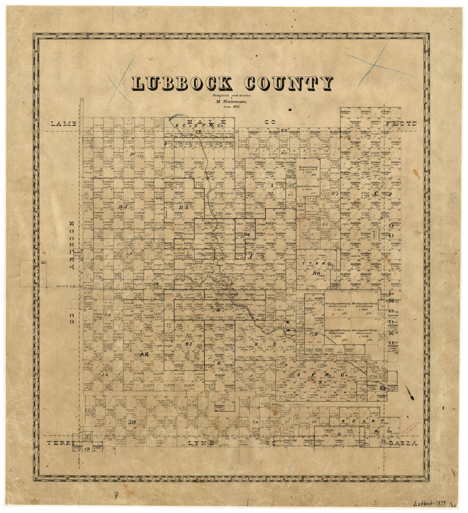
Lubbock County
-
Map/Doc
3829
-
Collection
General Map Collection
-
Object Dates
6/1879 (Creation Date)
-
People and Organizations
Texas General Land Office (Publisher)
Max Stakemann (Compiler)
Max Stakemann (Draftsman)
-
Counties
Lubbock
-
Subjects
County
-
Height x Width
23.8 x 21.7 inches
60.5 x 55.1 cm
-
Features
North Fork of Double Mountain Fork of Brazos River
Casa Marea Creek
Yellow House Creek
Estacado
Part of: General Map Collection
Cherokee County Working Sketch 22

Print $20.00
- Digital $50.00
Cherokee County Working Sketch 22
1972
Size 24.0 x 19.2 inches
Map/Doc 67977
Harris County Working Sketch 13

Print $20.00
- Digital $50.00
Harris County Working Sketch 13
1915
Size 19.9 x 11.0 inches
Map/Doc 65905
Upton County Sketch File 40

Print $6.00
- Digital $50.00
Upton County Sketch File 40
1961
Size 11.5 x 8.7 inches
Map/Doc 38914
Jefferson County Working Sketch 11

Print $20.00
- Digital $50.00
Jefferson County Working Sketch 11
1943
Size 46.6 x 43.0 inches
Map/Doc 66554

Boundary Between the United States & Mexico Agreed upon by the Joint Commission under the Treaty of Guadalupe Hidalgo

Print $4.00
- Digital $50.00
Boundary Between the United States & Mexico Agreed upon by the Joint Commission under the Treaty of Guadalupe Hidalgo
1853
Size 18.2 x 26.8 inches
Map/Doc 72879
Map of Portion of the Gulf of Mexico Adjoining Jefferson County Showing Subdivision Thereof for Mineral Development

Print $20.00
- Digital $50.00
Map of Portion of the Gulf of Mexico Adjoining Jefferson County Showing Subdivision Thereof for Mineral Development
1940
Size 17.7 x 20.2 inches
Map/Doc 3018
Flight Mission No. DIX-10P, Frame 170, Aransas County

Print $20.00
- Digital $50.00
Flight Mission No. DIX-10P, Frame 170, Aransas County
1956
Size 18.7 x 22.3 inches
Map/Doc 83960
Upton County Working Sketch 7

Print $20.00
- Digital $50.00
Upton County Working Sketch 7
1912
Size 26.3 x 29.9 inches
Map/Doc 69503
Fort Bend County Sketch File 34

Print $20.00
- Digital $50.00
Fort Bend County Sketch File 34
Size 22.3 x 18.0 inches
Map/Doc 11514
Flight Mission No. DAG-26K, Frame 56, Matagorda County

Print $20.00
- Digital $50.00
Flight Mission No. DAG-26K, Frame 56, Matagorda County
1953
Size 18.6 x 22.7 inches
Map/Doc 86576
Hale County Working Sketch 8

Print $20.00
- Digital $50.00
Hale County Working Sketch 8
1982
Size 22.2 x 34.5 inches
Map/Doc 63328
You may also like
Mills County Rolled Sketch 3

Print $20.00
- Digital $50.00
Mills County Rolled Sketch 3
1998
Size 26.4 x 37.9 inches
Map/Doc 6781
Maps of Gulf Intracoastal Waterway, Texas - Sabine River to the Rio Grande and connecting waterways including ship channels

Print $20.00
- Digital $50.00
Maps of Gulf Intracoastal Waterway, Texas - Sabine River to the Rio Grande and connecting waterways including ship channels
1966
Size 14.6 x 22.3 inches
Map/Doc 61925
Pecos County Sketch File 88

Print $6.00
- Digital $50.00
Pecos County Sketch File 88
1934
Size 17.0 x 11.0 inches
Map/Doc 33984
Val Verde County Working Sketch 74

Print $20.00
- Digital $50.00
Val Verde County Working Sketch 74
1970
Size 30.7 x 28.3 inches
Map/Doc 72209
Val Verde County Working Sketch 103

Print $20.00
- Digital $50.00
Val Verde County Working Sketch 103
1981
Size 37.1 x 39.9 inches
Map/Doc 72238
Floyd County Sketch File 19

Print $6.00
- Digital $50.00
Floyd County Sketch File 19
1913
Size 9.8 x 8.4 inches
Map/Doc 22769
[Sketch between Hemphill County and Oklahoma]
![89672, [Sketch between Hemphill County and Oklahoma], Twichell Survey Records](https://historictexasmaps.com/wmedia_w700/maps/89672-1.tif.jpg)
Print $40.00
- Digital $50.00
[Sketch between Hemphill County and Oklahoma]
Size 65.2 x 9.5 inches
Map/Doc 89672
Denton County Working Sketch 13

Print $20.00
- Digital $50.00
Denton County Working Sketch 13
1962
Size 25.7 x 36.2 inches
Map/Doc 68618
Gillespie County

Print $40.00
- Digital $50.00
Gillespie County
1887
Size 38.9 x 49.8 inches
Map/Doc 4956
Marion County Working Sketch 36

Print $20.00
- Digital $50.00
Marion County Working Sketch 36
1987
Size 23.5 x 28.9 inches
Map/Doc 70812
Brown County Sketch File 12

Print $4.00
- Digital $50.00
Brown County Sketch File 12
1870
Size 12.4 x 8.0 inches
Map/Doc 16602
Mexico und Texas

Print $20.00
- Digital $50.00
Mexico und Texas
1851
Size 15.8 x 19.1 inches
Map/Doc 93714