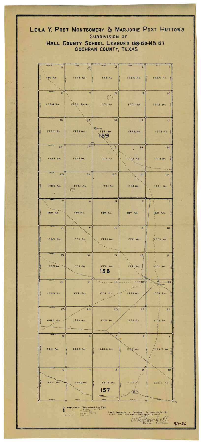
Leila Y. Post Montgomery & Marjorie Post Hutton's Subdivision of Hall County School Land Leagues 158-159-N 1/2 157, Cochran County, Texas
40-36
-
Map/Doc
90456
-
Collection
Twichell Survey Records
-
People and Organizations
W.D. Twichell (Surveyor/Engineer)
-
Counties
Cochran
-
Height x Width
8.4 x 18.4 inches
21.3 x 46.7 cm
Part of: Twichell Survey Records
[G. H. & H. Block 2]
![90714, [G. H. & H. Block 2], Twichell Survey Records](https://historictexasmaps.com/wmedia_w700/maps/90714-1.tif.jpg)
Print $20.00
- Digital $50.00
[G. H. & H. Block 2]
Size 24.1 x 18.5 inches
Map/Doc 90714
Cow Bayou Oil Field, Orange County, Texas

Print $20.00
- Digital $50.00
Cow Bayou Oil Field, Orange County, Texas
Size 24.0 x 18.8 inches
Map/Doc 93016
University of Texas System University Lands

Print $20.00
- Digital $50.00
University of Texas System University Lands
Size 17.9 x 23.3 inches
Map/Doc 93244
[E. L. & R. R. Block 10]
![91353, [E. L. & R. R. Block 10], Twichell Survey Records](https://historictexasmaps.com/wmedia_w700/maps/91353-1.tif.jpg)
Print $20.00
- Digital $50.00
[E. L. & R. R. Block 10]
Size 25.3 x 16.5 inches
Map/Doc 91353
[Capitol Leagues 225-238]
![90677, [Capitol Leagues 225-238], Twichell Survey Records](https://historictexasmaps.com/wmedia_w700/maps/90677-1.tif.jpg)
Print $20.00
- Digital $50.00
[Capitol Leagues 225-238]
Size 23.2 x 13.0 inches
Map/Doc 90677
Bryan Walker Farm

Print $20.00
- Digital $50.00
Bryan Walker Farm
Size 17.1 x 15.5 inches
Map/Doc 92339
Map of N. W. Portion Blk G. Gaines Co.

Print $20.00
- Digital $50.00
Map of N. W. Portion Blk G. Gaines Co.
1914
Size 37.4 x 26.7 inches
Map/Doc 90867
Amarillo City Stock Yards

Print $20.00
- Digital $50.00
Amarillo City Stock Yards
Size 21.6 x 12.2 inches
Map/Doc 91745
[Blks. 8, 10, CC 41, and 32]
![90118, [Blks. 8, 10, CC 41, and 32], Twichell Survey Records](https://historictexasmaps.com/wmedia_w700/maps/90118-1.tif.jpg)
Print $20.00
- Digital $50.00
[Blks. 8, 10, CC 41, and 32]
Size 40.6 x 15.4 inches
Map/Doc 90118
Walter Butler Irrigated Farm

Print $20.00
- Digital $50.00
Walter Butler Irrigated Farm
Size 24.4 x 17.7 inches
Map/Doc 92318
[J. Poitevent Block 2, T. T. RR. Block 2, C. C. Slaughter Block 1]
![90619, [J. Poitevent Block 2, T. T. RR. Block 2, C. C. Slaughter Block 1], Twichell Survey Records](https://historictexasmaps.com/wmedia_w700/maps/90619-1.tif.jpg)
Print $2.00
- Digital $50.00
[J. Poitevent Block 2, T. T. RR. Block 2, C. C. Slaughter Block 1]
Size 9.1 x 11.7 inches
Map/Doc 90619
Map of Terry County

Print $2.00
- Digital $50.00
Map of Terry County
Size 7.6 x 8.3 inches
Map/Doc 92888
You may also like
Topographic and Road Map, Travis County

Print $40.00
- Digital $50.00
Topographic and Road Map, Travis County
1932
Size 37.5 x 48.2 inches
Map/Doc 4673
[Right of Way & Track Map, The Texas & Pacific Ry. Co. Main Line]
![64671, [Right of Way & Track Map, The Texas & Pacific Ry. Co. Main Line], General Map Collection](https://historictexasmaps.com/wmedia_w700/maps/64671.tif.jpg)
Print $20.00
- Digital $50.00
[Right of Way & Track Map, The Texas & Pacific Ry. Co. Main Line]
Size 10.8 x 19.0 inches
Map/Doc 64671
J. De Cordova's Map of the State of Texas Compiled from the records of the General Land Office of the State

Print $20.00
- Digital $50.00
J. De Cordova's Map of the State of Texas Compiled from the records of the General Land Office of the State
1851
Size 34.9 x 32.0 inches
Map/Doc 442
Collin County Rolled Sketch 1

Print $20.00
- Digital $50.00
Collin County Rolled Sketch 1
1953
Size 34.9 x 35.6 inches
Map/Doc 8635
Lipscomb County Rolled Sketch 2

Print $20.00
- Digital $50.00
Lipscomb County Rolled Sketch 2
1886
Size 24.1 x 30.2 inches
Map/Doc 6628
Leon County Rolled Sketch 11

Print $20.00
- Digital $50.00
Leon County Rolled Sketch 11
1965
Size 16.8 x 19.7 inches
Map/Doc 6599
Parker County Working Sketch 28

Print $20.00
- Digital $50.00
Parker County Working Sketch 28
2009
Map/Doc 89011
Flight Mission No. BQR-9K, Frame 6, Brazoria County

Print $20.00
- Digital $50.00
Flight Mission No. BQR-9K, Frame 6, Brazoria County
1952
Size 18.7 x 22.4 inches
Map/Doc 84035
Nueces County Rolled Sketch 80

Print $58.00
Nueces County Rolled Sketch 80
1982
Size 24.2 x 36.7 inches
Map/Doc 6952
Galveston County Sketch File 67

Print $4.00
- Digital $50.00
Galveston County Sketch File 67
1988
Size 11.3 x 8.7 inches
Map/Doc 23782
Val Verde County Working Sketch 55

Print $20.00
- Digital $50.00
Val Verde County Working Sketch 55
1957
Size 20.1 x 28.6 inches
Map/Doc 72190
Andrews County Rolled Sketch 13

Print $20.00
- Digital $50.00
Andrews County Rolled Sketch 13
1934
Size 38.3 x 26.2 inches
Map/Doc 77163