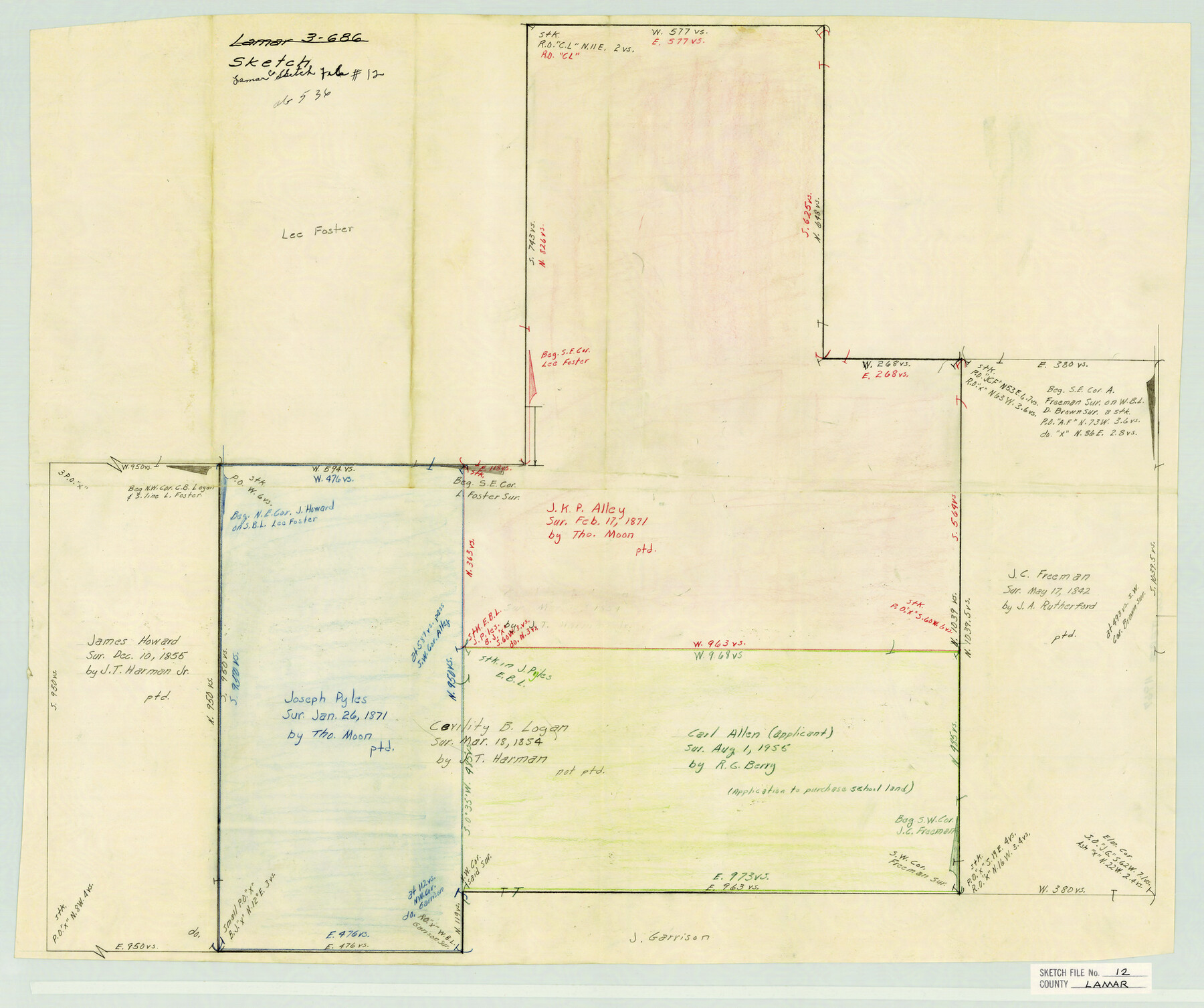
Lamar County Sketch File 12
[Sketch of area in the northwest part of Lamar County]
-
Map/Doc
11967
-
Collection
General Map Collection
-
Counties
Lamar
-
Subjects
Surveying Sketch File
-
Height x Width
19.5 x 23.3 inches
49.5 x 59.2 cm
-
Medium
paper, manuscript
Part of: General Map Collection
Map of Hamilton County

Print $20.00
- Digital $50.00
Map of Hamilton County
1863
Size 22.8 x 25.8 inches
Map/Doc 3621
Calcasieu Pass to Sabine Pass

Print $20.00
- Digital $50.00
Calcasieu Pass to Sabine Pass
1946
Size 45.0 x 35.7 inches
Map/Doc 69807
[Bastrop District]
![16941, [Bastrop District], General Map Collection](https://historictexasmaps.com/wmedia_w700/maps/16941-1.tif.jpg)
Print $40.00
- Digital $50.00
[Bastrop District]
1838
Size 67.3 x 44.2 inches
Map/Doc 16941
Armstrong County Rolled Sketch 4

Print $40.00
- Digital $50.00
Armstrong County Rolled Sketch 4
1876
Size 37.8 x 70.8 inches
Map/Doc 8426
Atascosa County Rolled Sketch 24

Print $20.00
- Digital $50.00
Atascosa County Rolled Sketch 24
Size 38.3 x 45.2 inches
Map/Doc 5101
Flight Mission No. CLL-1N, Frame 86, Willacy County

Print $20.00
- Digital $50.00
Flight Mission No. CLL-1N, Frame 86, Willacy County
1954
Size 18.4 x 22.1 inches
Map/Doc 87032
Jim Wells County Working Sketch 13

Print $20.00
- Digital $50.00
Jim Wells County Working Sketch 13
1980
Size 36.7 x 26.3 inches
Map/Doc 66611
Cottle County Sketch File 3

Print $4.00
- Digital $50.00
Cottle County Sketch File 3
Size 10.0 x 8.4 inches
Map/Doc 19457
Real County Working Sketch 51

Print $20.00
- Digital $50.00
Real County Working Sketch 51
1957
Size 28.1 x 24.1 inches
Map/Doc 71943
Nueces County Rolled Sketch 106

Print $104.00
Nueces County Rolled Sketch 106
1986
Size 18.2 x 24.6 inches
Map/Doc 7097
Wilson County Boundary File 5a

Print $20.00
- Digital $50.00
Wilson County Boundary File 5a
Size 12.0 x 28.0 inches
Map/Doc 60118
Ward County Rolled Sketch 1

Print $40.00
- Digital $50.00
Ward County Rolled Sketch 1
1888
Size 42.6 x 120.4 inches
Map/Doc 76165
You may also like
Map of a Route from Austin-City to Paso del Norte & c.

Print $20.00
- Digital $50.00
Map of a Route from Austin-City to Paso del Norte & c.
1849
Size 11.7 x 30.5 inches
Map/Doc 2121
Kimble County Working Sketch 25

Print $20.00
- Digital $50.00
Kimble County Working Sketch 25
1937
Size 22.9 x 22.7 inches
Map/Doc 70093
Rockwall County Boundary File 2

Print $12.00
- Digital $50.00
Rockwall County Boundary File 2
Size 14.4 x 8.9 inches
Map/Doc 58385
University Lands Blocks 34 to 37, Terrell County, Isogonic Chart & Meridian Changes

Print $20.00
- Digital $50.00
University Lands Blocks 34 to 37, Terrell County, Isogonic Chart & Meridian Changes
Size 23.2 x 22.4 inches
Map/Doc 62940
Frio County Sketch File 17

Print $6.00
- Digital $50.00
Frio County Sketch File 17
1955
Size 14.3 x 8.7 inches
Map/Doc 23152
[East Part of Bailey County and West Part of Lamb County]
![91048, [East Part of Bailey County and West Part of Lamb County], Twichell Survey Records](https://historictexasmaps.com/wmedia_w700/maps/91048-1.tif.jpg)
Print $20.00
- Digital $50.00
[East Part of Bailey County and West Part of Lamb County]
Size 22.5 x 18.3 inches
Map/Doc 91048
San Saba County Working Sketch 9

Print $20.00
- Digital $50.00
San Saba County Working Sketch 9
1983
Size 33.8 x 42.8 inches
Map/Doc 63797
Zavalla County

Print $20.00
- Digital $50.00
Zavalla County
1879
Size 22.8 x 27.2 inches
Map/Doc 4182
Jeff Davis County Rolled Sketch 23A

Print $11.00
- Digital $50.00
Jeff Davis County Rolled Sketch 23A
1886
Size 9.9 x 15.3 inches
Map/Doc 46293
The Republic County of Nacogdoches. January 16, 1843

Print $20.00
The Republic County of Nacogdoches. January 16, 1843
2020
Size 15.9 x 21.8 inches
Map/Doc 96249
Flight Mission No. CUG-3P, Frame 166, Kleberg County

Print $20.00
- Digital $50.00
Flight Mission No. CUG-3P, Frame 166, Kleberg County
1956
Size 18.6 x 22.3 inches
Map/Doc 86286
Eastland County Working Sketch 48

Print $20.00
- Digital $50.00
Eastland County Working Sketch 48
1981
Size 35.1 x 25.5 inches
Map/Doc 68829