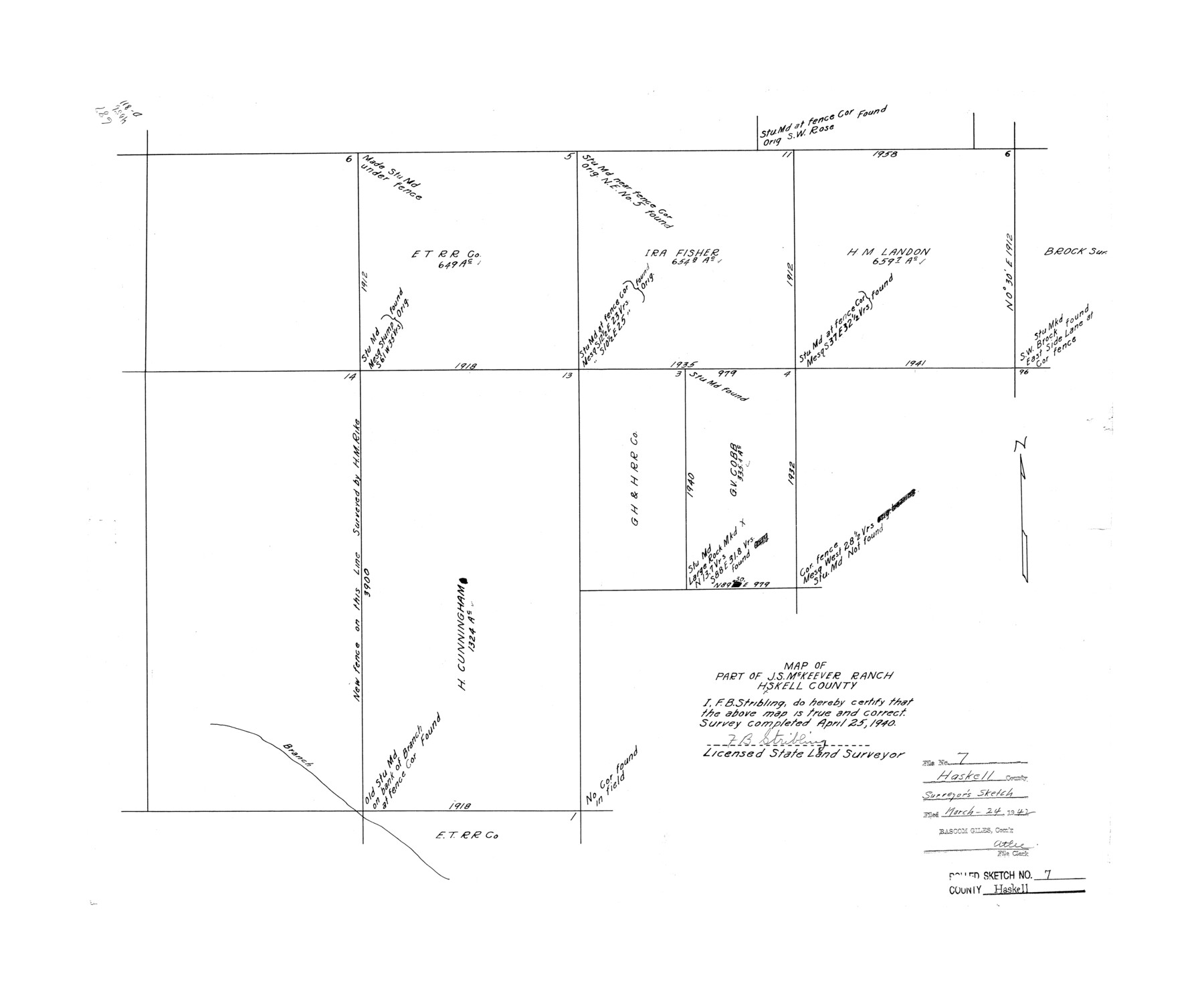
Haskell County Rolled Sketch 7
Map of part of J.S. McKeever Ranch
-
Map/Doc
6167
-
Collection
General Map Collection
-
Object Dates
1940/4/25 (Creation Date)
1942/3/24 (File Date)
-
People and Organizations
F.B. Stribling (Surveyor/Engineer)
-
Counties
Haskell
-
Subjects
Surveying Rolled Sketch
-
Height x Width
22.0 x 26.5 inches
55.9 x 67.3 cm
Part of: General Map Collection
Grimes County Sketch File 5

Print $4.00
- Digital $50.00
Grimes County Sketch File 5
1881
Size 9.2 x 8.3 inches
Map/Doc 24642
Flight Mission No. DAG-24K, Frame 48, Matagorda County

Print $20.00
- Digital $50.00
Flight Mission No. DAG-24K, Frame 48, Matagorda County
1953
Size 18.5 x 22.1 inches
Map/Doc 86535
Austin Street Map & Guide

Digital $50.00
Austin Street Map & Guide
Size 35.4 x 23.1 inches
Map/Doc 94435
Map of the District of San Patricio and Nueces

Print $40.00
- Digital $50.00
Map of the District of San Patricio and Nueces
Size 93.8 x 38.4 inches
Map/Doc 93366
Jefferson County Sketch File 6

Print $4.00
- Digital $50.00
Jefferson County Sketch File 6
1860
Size 12.3 x 7.8 inches
Map/Doc 28110
Pecos County Rolled Sketch 177

Print $20.00
- Digital $50.00
Pecos County Rolled Sketch 177
1972
Size 27.4 x 38.0 inches
Map/Doc 7297
Map of Terry County

Print $20.00
- Digital $50.00
Map of Terry County
1893
Size 27.4 x 23.3 inches
Map/Doc 4076
Old Miscellaneous File 39

Print $10.00
- Digital $50.00
Old Miscellaneous File 39
1893
Size 14.2 x 8.8 inches
Map/Doc 75284
Sterling County Sketch File 15

Print $8.00
- Digital $50.00
Sterling County Sketch File 15
1935
Size 11.1 x 8.8 inches
Map/Doc 37150
Jeff Davis County

Print $40.00
- Digital $50.00
Jeff Davis County
1893
Size 26.2 x 48.2 inches
Map/Doc 3719
Flight Mission No. DQN-1K, Frame 79, Calhoun County

Print $20.00
- Digital $50.00
Flight Mission No. DQN-1K, Frame 79, Calhoun County
1953
Size 18.5 x 22.2 inches
Map/Doc 84164
Galveston County NRC Article 33.136 Sketch 69

Print $76.00
- Digital $50.00
Galveston County NRC Article 33.136 Sketch 69
2012
Size 24.0 x 36.0 inches
Map/Doc 94669
You may also like
United States - Gulf Coast - Padre I. and Laguna Madre Lat. 27° 12' to Lat. 26° 33' Texas

Print $20.00
- Digital $50.00
United States - Gulf Coast - Padre I. and Laguna Madre Lat. 27° 12' to Lat. 26° 33' Texas
1913
Size 26.9 x 18.2 inches
Map/Doc 72820
Donley County Boundary File 5

Print $4.00
- Digital $50.00
Donley County Boundary File 5
Size 11.2 x 8.8 inches
Map/Doc 52635
Coast Chart No. 210 Aransas Pass and Corpus Christi Bay with the coast to latitude 27° 12' Texas

Print $20.00
- Digital $50.00
Coast Chart No. 210 Aransas Pass and Corpus Christi Bay with the coast to latitude 27° 12' Texas
1887
Size 27.6 x 18.3 inches
Map/Doc 72790
Bauer & Cockrell Lands Located in Martin County, Texas

Print $20.00
- Digital $50.00
Bauer & Cockrell Lands Located in Martin County, Texas
1908
Size 28.5 x 22.3 inches
Map/Doc 91365
Colorado County Working Sketch 15

Print $40.00
- Digital $50.00
Colorado County Working Sketch 15
1949
Size 31.4 x 63.3 inches
Map/Doc 68115
[Val Verde County]
![63096, [Val Verde County], General Map Collection](https://historictexasmaps.com/wmedia_w700/maps/63096.tif.jpg)
Print $20.00
- Digital $50.00
[Val Verde County]
1898
Size 42.6 x 34.9 inches
Map/Doc 63096
Hale County Sketch File 9

Print $14.00
- Digital $50.00
Hale County Sketch File 9
1893
Size 6.1 x 2.6 inches
Map/Doc 24730
[Surveys in Power and Hewetson's Colony along the Aransas River, shown as Aransasu and Chiltipin Creek]
![31, [Surveys in Power and Hewetson's Colony along the Aransas River, shown as Aransasu and Chiltipin Creek], General Map Collection](https://historictexasmaps.com/wmedia_w700/maps/31.tif.jpg)
Print $20.00
- Digital $50.00
[Surveys in Power and Hewetson's Colony along the Aransas River, shown as Aransasu and Chiltipin Creek]
Size 12.9 x 17.0 inches
Map/Doc 31

[Blocks O, H, B, S, RG, and 11]
![91333, [Blocks O, H, B, S, RG, and 11], Twichell Survey Records](https://historictexasmaps.com/wmedia_w700/maps/91333-1.tif.jpg)
Print $20.00
- Digital $50.00
[Blocks O, H, B, S, RG, and 11]
1921
Size 24.9 x 15.3 inches
Map/Doc 91333
Flight Mission No. CRC-4R, Frame 110, Chambers County

Print $20.00
- Digital $50.00
Flight Mission No. CRC-4R, Frame 110, Chambers County
1956
Size 18.6 x 22.3 inches
Map/Doc 84907
Donley County Working Sketch 5

Print $40.00
- Digital $50.00
Donley County Working Sketch 5
Size 54.3 x 32.9 inches
Map/Doc 68738