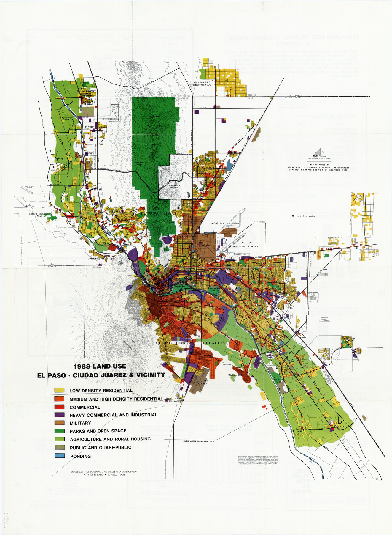
1988 Land Use - El Paso, Ciudad Juarez and Vicinity
-
Map/Doc
87369
-
Collection
General Map Collection
-
Object Dates
1988 (Creation Date)
-
People and Organizations
City of El Paso Department of Planning (Publisher)
-
Counties
El Paso
-
Subjects
City
-
Height x Width
34.2 x 25.1 inches
86.9 x 63.8 cm
-
Medium
paper, print
-
Comments
See 87370 for reverse which has a variety of stats on land use and demographics for the El Paso area.
-
Features
West Texas Airport
Sunland Park, New Mexico
Chamizal National Mountain
Ascarate Park
Border Highway
El Chamizal
Pronaf
University of Texas El Paso
Juarez Mountains
Ciudad Juarez, Mexico
Chihuahua, Mexico
Santa Teresa, New Mexico
Horizon City
Zaragoza, Mexico
Juarez [Mexico] Airport
Rio Bosque Park
Socorro
State highway 20
Clint
San Elizario
FM 558
Canutillo
Rio Grande
FM 1905
Anthony
IH-10
FM 2529
Anthony, New Mexico
Chaparral, New Mexico
Franklin Mountains State Park
Vinton
Westway
El Paso
FM 259
Tom Mays Park
Castner Range
Loop 375
Military Reservation
El Paso International Airport
Biggs Army Air Field
Fort Bliss
McKelligon Canyon Park
Part of: General Map Collection
Presidio County Working Sketch 17

Print $20.00
- Digital $50.00
Presidio County Working Sketch 17
1943
Size 17.5 x 30.9 inches
Map/Doc 71693
Bowie County Sketch File 2

Print $40.00
- Digital $50.00
Bowie County Sketch File 2
Size 19.6 x 15.1 inches
Map/Doc 10940
Galveston County Rolled Sketch 26

Print $950.00
- Digital $50.00
Galveston County Rolled Sketch 26
Size 10.6 x 16.1 inches
Map/Doc 44849
Nueces County NRC Article 33.136 Sketch 6

Print $44.00
- Digital $50.00
Nueces County NRC Article 33.136 Sketch 6
2002
Size 23.4 x 35.2 inches
Map/Doc 78658
Val Verde County Sketch File Z12

Print $4.00
- Digital $50.00
Val Verde County Sketch File Z12
1898
Size 11.4 x 8.8 inches
Map/Doc 39140
Childress County Rolled Sketch 5

Print $20.00
- Digital $50.00
Childress County Rolled Sketch 5
1913
Size 31.2 x 24.7 inches
Map/Doc 5439
Flight Mission No. CRC-4R, Frame 83, Chambers County

Print $20.00
- Digital $50.00
Flight Mission No. CRC-4R, Frame 83, Chambers County
1956
Size 18.8 x 22.5 inches
Map/Doc 84888
Hudspeth County Sketch File 16

Print $10.00
- Digital $50.00
Hudspeth County Sketch File 16
1925
Size 14.3 x 8.8 inches
Map/Doc 26948
Rockwall County Boundary File 6

Print $48.00
- Digital $50.00
Rockwall County Boundary File 6
Size 14.0 x 8.6 inches
Map/Doc 58420
Galveston County NRC Article 33.136 Sketch 85

Print $42.00
- Digital $50.00
Galveston County NRC Article 33.136 Sketch 85
2015
Size 36.4 x 24.5 inches
Map/Doc 94965
DeWitt County Working Sketch 2a

Print $20.00
- Digital $50.00
DeWitt County Working Sketch 2a
1940
Size 25.2 x 29.8 inches
Map/Doc 68592
[Surveys in McMullen and McGloin's Colony along the San Antonio River]
![30, [Surveys in McMullen and McGloin's Colony along the San Antonio River], General Map Collection](https://historictexasmaps.com/wmedia_w700/maps/30-1.tif.jpg)
Print $20.00
- Digital $50.00
[Surveys in McMullen and McGloin's Colony along the San Antonio River]
1828
Size 19.3 x 24.5 inches
Map/Doc 30
You may also like
Dr. S. C. Arnett Farm Part Section 5, Block E2

Print $20.00
- Digital $50.00
Dr. S. C. Arnett Farm Part Section 5, Block E2
Size 12.7 x 15.8 inches
Map/Doc 92296
Jasper County Rolled Sketch 8

Print $20.00
- Digital $50.00
Jasper County Rolled Sketch 8
Size 17.7 x 12.0 inches
Map/Doc 6356
Atascosa County Sketch File 4

Print $7.00
- Digital $50.00
Atascosa County Sketch File 4
1854
Size 8.1 x 6.5 inches
Map/Doc 13745
Amistad International Reservoir on Rio Grande 74

Print $20.00
- Digital $50.00
Amistad International Reservoir on Rio Grande 74
1949
Size 28.5 x 40.2 inches
Map/Doc 75501
Howard County Rolled Sketch 8

Print $20.00
- Digital $50.00
Howard County Rolled Sketch 8
Size 43.0 x 18.4 inches
Map/Doc 6238
Property of Hobbs Trailers Manufacturing Company

Print $20.00
- Digital $50.00
Property of Hobbs Trailers Manufacturing Company
1956
Size 36.6 x 18.9 inches
Map/Doc 92733
McMullen County Sketch File 35

Print $10.00
- Digital $50.00
McMullen County Sketch File 35
Size 9.7 x 8.5 inches
Map/Doc 31402
Survey of a Portion of Lot. No. 1 of Spear League

Print $20.00
- Digital $50.00
Survey of a Portion of Lot. No. 1 of Spear League
1911
Size 12.2 x 24.2 inches
Map/Doc 477
Bastrop County Sketch File 12

Print $12.00
- Digital $50.00
Bastrop County Sketch File 12
1846
Size 12.8 x 8.4 inches
Map/Doc 14064
Culberson County Rolled Sketch 21

Print $20.00
- Digital $50.00
Culberson County Rolled Sketch 21
1915
Size 31.2 x 15.6 inches
Map/Doc 5654
Guadalupe County Sketch File 7

Print $20.00
- Digital $50.00
Guadalupe County Sketch File 7
Size 15.6 x 19.5 inches
Map/Doc 11590
Flight Mission No. DAH-17M, Frame 27, Orange County

Print $20.00
- Digital $50.00
Flight Mission No. DAH-17M, Frame 27, Orange County
1953
Size 18.6 x 22.3 inches
Map/Doc 86890