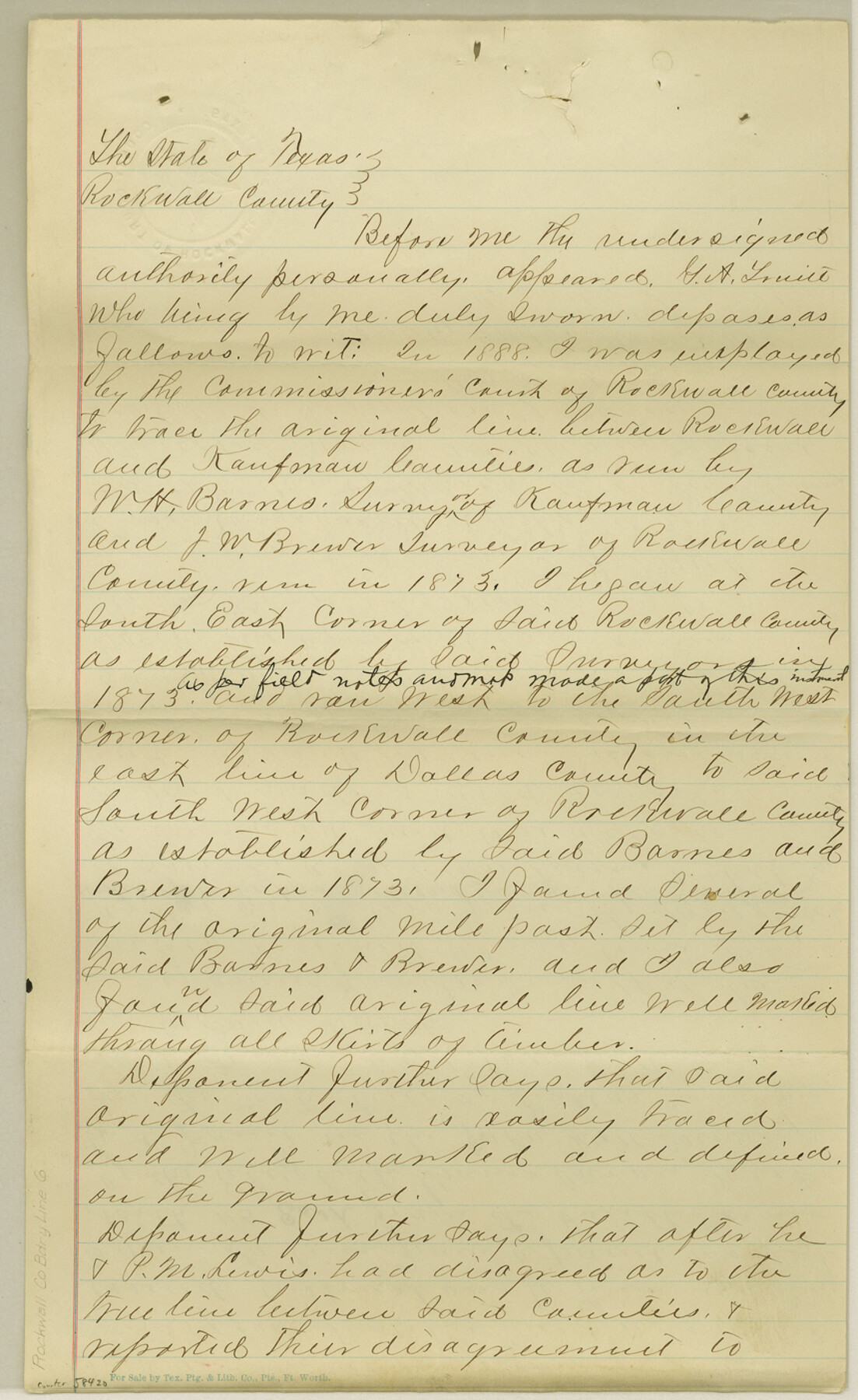
Rockwall County Boundary File 6
[Surveyor's Affidavit regarding Rockwall-Kaufman Boundary Line; Affidavit of former Rockwall County Commissioner regarding Rockwall-Kaufman Boundary line]
- 
                          Map/Doc58420
- 
                            CollectionGeneral Map Collection
- 
                            CountiesRockwall
- 
                            SubjectsCounty Boundaries
- 
                            Height x Width14.0 x 8.6 inches35.6 x 21.8 cm
Part of: General Map Collection
            Overlay For Flight Mission No. BRE-2P, Frame 110 of H. A. Pierce Corrected Survey, December 21, 1950 of Cyrus Egery Survey of June 15, 1855


                                            Print $20.00                    
                                             -                         Digital $50.00                                    
                Overlay For Flight Mission No. BRE-2P, Frame 110 of H. A. Pierce Corrected Survey, December 21, 1950 of Cyrus Egery Survey of June 15, 1855
1956
Size 18.3 x 20.4 inches
                                Map/Doc 86795
            
            [Surveys in Bastrop County]
            
                                    ![3179, [Surveys in Bastrop County], General Map Collection](https://historictexasmaps.com/wmedia_w700/maps/3179.tif.jpg) 


    ![3179, [Surveys in Bastrop County], General Map Collection](https://historictexasmaps.com/wmedia_w700/maps/3179.tif.jpg) 
                                
            
                                            Print $2.00                    
                                             -                         Digital $50.00                                    
                [Surveys in Bastrop County]
1841
Size 11.3 x 8.4 inches
                                Map/Doc 3179
            
            Winkler County Working Sketch 4


                                            Print $20.00                    
                                             -                         Digital $50.00                                    
                Winkler County Working Sketch 4
1954
Size 36.7 x 30.1 inches
                                Map/Doc 72598
            
            Flight Mission No. CGI-3N, Frame 121, Cameron County


                                            Print $20.00                    
                                             -                         Digital $50.00                                    
                Flight Mission No. CGI-3N, Frame 121, Cameron County
1954
Size 18.5 x 22.3 inches
                                Map/Doc 84594
            
            Limestone County Working Sketch 1


                                            Print $20.00                    
                                             -                         Digital $50.00                                    
                Limestone County Working Sketch 1
Size 15.4 x 13.0 inches
                                Map/Doc 70551
            
            Terry County Sketch File 5


                                            Print $40.00                    
                                             -                         Digital $50.00                                    
                Terry County Sketch File 5
1916
Size 15.6 x 58.6 inches
                                Map/Doc 10391
            
            La Salle County Working Sketch 39


                                            Print $20.00                    
                                             -                         Digital $50.00                                    
                La Salle County Working Sketch 39
1963
Size 30.4 x 25.4 inches
                                Map/Doc 70340
            
            Loving County Sketch File 9


                                            Print $36.00                    
                                             -                         Digital $50.00                                    
                Loving County Sketch File 9
2015
Size 14.0 x 8.5 inches
                                Map/Doc 93794
            
            Kinney County Rolled Sketch 16


                                            Print $20.00                    
                                             -                         Digital $50.00                                    
                Kinney County Rolled Sketch 16
1963
Size 36.4 x 43.8 inches
                                Map/Doc 9356
            
            Clay County Boundary File 15


                                            Print $8.00                    
                                             -                         Digital $50.00                                    
                Clay County Boundary File 15
Size 13.3 x 8.2 inches
                                Map/Doc 51418
            
            Callahan County Sketch File 10b


                                            Print $6.00                    
                                             -                         Digital $50.00                                    
                Callahan County Sketch File 10b
Size 12.1 x 10.8 inches
                                Map/Doc 35883
            You may also like
            Sutton County Rolled Sketch 43


                                            Print $20.00                    
                                             -                         Digital $50.00                                    
                Sutton County Rolled Sketch 43
1939
Size 18.7 x 26.8 inches
                                Map/Doc 7885
            
            Photo Index of Texas Coast - Sheet 5 of 6


                                            Print $20.00                    
                                             -                         Digital $50.00                                    
                Photo Index of Texas Coast - Sheet 5 of 6
1954
Size 20.0 x 24.0 inches
                                Map/Doc 83443
            
            Flight Mission No. CUG-3P, Frame 136, Kleberg County


                                            Print $20.00                    
                                             -                         Digital $50.00                                    
                Flight Mission No. CUG-3P, Frame 136, Kleberg County
1956
Size 18.5 x 22.3 inches
                                Map/Doc 86271
            
            Jasper County Sketch File 12a


                                            Print $16.00                    
                                             -                         Digital $50.00                                    
                Jasper County Sketch File 12a
1881
Size 13.0 x 8.4 inches
                                Map/Doc 27794
            
            Map of Claude - Claude, Armstrong Co.


                                            Print $20.00                    
                                             -                         Digital $50.00                                    
                Map of Claude - Claude, Armstrong Co.
Size 46.9 x 38.5 inches
                                Map/Doc 89743
            
            Leon County Sketch File 24


                                            Print $70.00                    
                                             -                         Digital $50.00                                    
                Leon County Sketch File 24
1932
Size 11.2 x 8.7 inches
                                Map/Doc 29781
            
            Hardin County Working Sketch 6


                                            Print $20.00                    
                                             -                         Digital $50.00                                    
                Hardin County Working Sketch 6
1922
Size 16.2 x 28.4 inches
                                Map/Doc 63404
            
            Crane County Rolled Sketch 15


                                            Print $40.00                    
                                             -                         Digital $50.00                                    
                Crane County Rolled Sketch 15
1946
Size 27.2 x 49.5 inches
                                Map/Doc 8682
            
            The Mexican Municipality of Washington. Proposed Creation, ca Spring 1835


                                            Print $20.00                    
                                    
                The Mexican Municipality of Washington. Proposed Creation, ca Spring 1835
2020
Size 13.1 x 21.7 inches
                                Map/Doc 96035
            
            Calhoun County Rolled Sketch 13


                                            Print $20.00                    
                                             -                         Digital $50.00                                    
                Calhoun County Rolled Sketch 13
1948
Size 43.0 x 41.0 inches
                                Map/Doc 8547
            
            Potter County Sketch


                                            Print $20.00                    
                                             -                         Digital $50.00                                    
                Potter County Sketch
Size 16.3 x 20.9 inches
                                Map/Doc 91808
            
            Freestone County Sketch File 26


                                            Print $22.00                    
                                             -                         Digital $50.00                                    
                Freestone County Sketch File 26
1880
Size 8.2 x 13.2 inches
                                Map/Doc 23096
             
                            