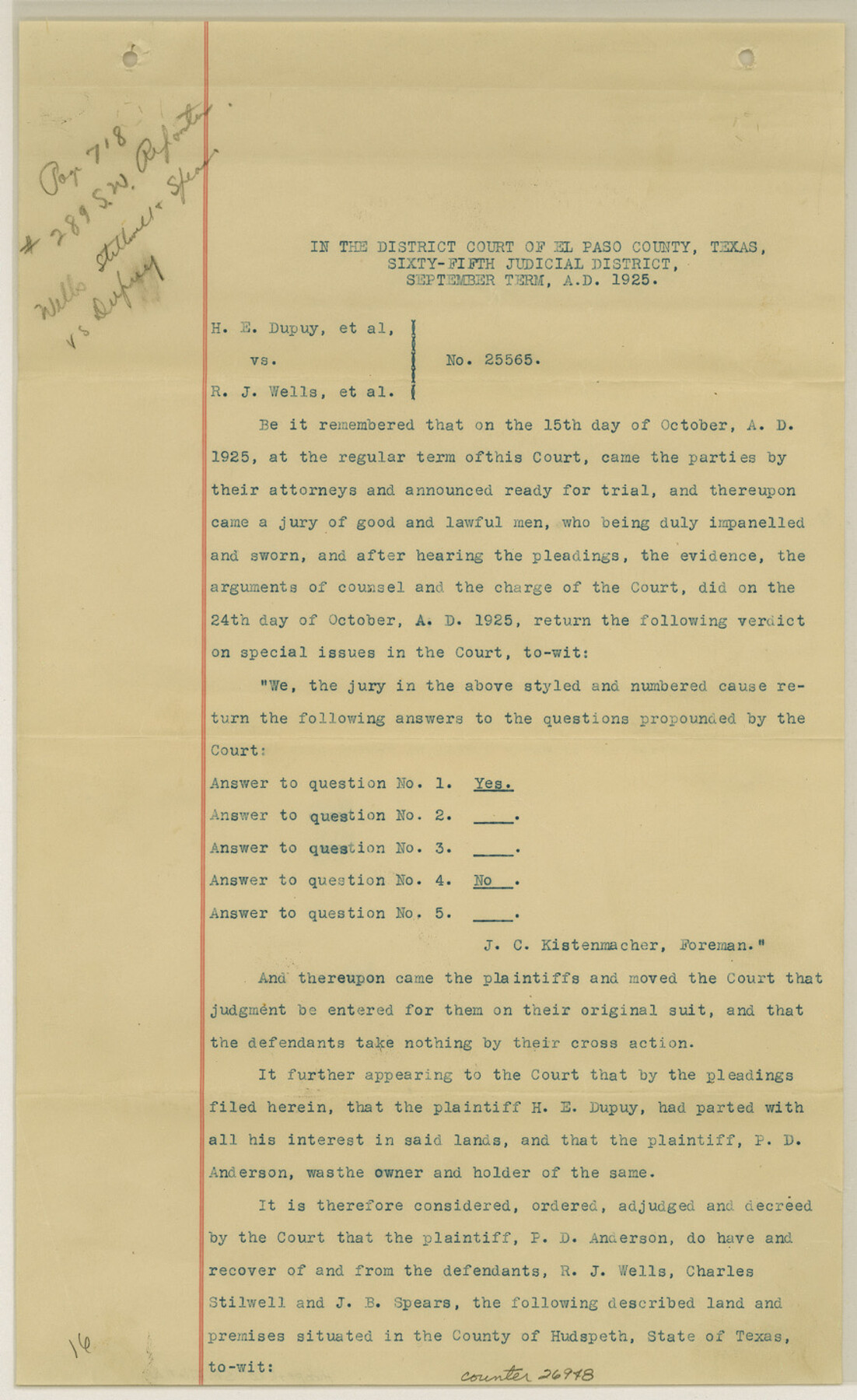
Hudspeth County Sketch File 16
[Decree of Court - H. E. Dupuy, et al vs. R. J. Wells, et al]
-
Map/Doc
26948
-
Collection
General Map Collection
-
Object Dates
9/1925 (Creation Date)
-
People and Organizations
Joseph Tivey (Surveyor/Engineer)
R.E. Hardaway (Surveyor/Engineer)
-
Counties
Hudspeth
-
Subjects
Surveying Sketch File
-
Height x Width
14.3 x 8.8 inches
36.3 x 22.4 cm
-
Medium
paper, print
Part of: General Map Collection
Marion County Sketch File 2

Print $4.00
- Digital $50.00
Marion County Sketch File 2
1853
Size 8.3 x 14.2 inches
Map/Doc 30564
Navigation Maps of Gulf Intracoastal Waterway, Port Arthur to Brownsville, Texas

Print $4.00
- Digital $50.00
Navigation Maps of Gulf Intracoastal Waterway, Port Arthur to Brownsville, Texas
1951
Size 16.8 x 21.3 inches
Map/Doc 65450
Bell County Sketch File 10

Print $4.00
- Digital $50.00
Bell County Sketch File 10
1851
Size 12.7 x 8.4 inches
Map/Doc 14381
[Sketch for Mineral Application 24072, San Jacinto River]
![65596, [Sketch for Mineral Application 24072, San Jacinto River], General Map Collection](https://historictexasmaps.com/wmedia_w700/maps/65596.tif.jpg)
Print $20.00
- Digital $50.00
[Sketch for Mineral Application 24072, San Jacinto River]
1929
Size 24.5 x 18.5 inches
Map/Doc 65596
Travis County Sketch File 22

Print $6.00
- Digital $50.00
Travis County Sketch File 22
1875
Size 8.5 x 8.5 inches
Map/Doc 38327
Bandera County Working Sketch 23

Print $20.00
- Digital $50.00
Bandera County Working Sketch 23
1950
Size 35.8 x 29.6 inches
Map/Doc 67619
Presidio County Rolled Sketch 88

Print $20.00
- Digital $50.00
Presidio County Rolled Sketch 88
1946
Size 34.8 x 29.9 inches
Map/Doc 9780
Starr County Rolled Sketch 11

Print $20.00
- Digital $50.00
Starr County Rolled Sketch 11
1912
Size 16.5 x 16.4 inches
Map/Doc 7798
Flight Mission No. BRE-1P, Frame 114, Nueces County

Print $20.00
- Digital $50.00
Flight Mission No. BRE-1P, Frame 114, Nueces County
1956
Size 18.6 x 22.9 inches
Map/Doc 86680
Harrison County Working Sketch 34

Print $20.00
- Digital $50.00
Harrison County Working Sketch 34
2015
Size 13.7 x 17.9 inches
Map/Doc 93726
Aransas County Working Sketch 15

Print $20.00
- Digital $50.00
Aransas County Working Sketch 15
1956
Size 22.2 x 19.0 inches
Map/Doc 67182
Reeves County Rolled Sketch 23

Print $20.00
- Digital $50.00
Reeves County Rolled Sketch 23
1982
Size 19.6 x 25.5 inches
Map/Doc 7491
You may also like
Aransas County Working Sketch 13

Print $20.00
- Digital $50.00
Aransas County Working Sketch 13
1950
Size 26.0 x 42.2 inches
Map/Doc 67180
Cienega Ranch

Print $20.00
- Digital $50.00
Cienega Ranch
1947
Size 17.5 x 17.1 inches
Map/Doc 92287
Runnels County Sketch File 36

Print $20.00
Runnels County Sketch File 36
1889
Size 20.9 x 19.6 inches
Map/Doc 12267
Glasscock County Working Sketch 5

Print $20.00
- Digital $50.00
Glasscock County Working Sketch 5
1926
Size 16.1 x 28.0 inches
Map/Doc 63178
Harris County Rolled Sketch 102

Print $20.00
- Digital $50.00
Harris County Rolled Sketch 102
2009
Size 24.8 x 36.5 inches
Map/Doc 89585
Flight Mission No. BQR-12K, Frame 47, Brazoria County

Print $20.00
- Digital $50.00
Flight Mission No. BQR-12K, Frame 47, Brazoria County
1952
Size 18.7 x 22.4 inches
Map/Doc 84062
Flight Mission No. DAG-21K, Frame 89, Matagorda County

Print $20.00
- Digital $50.00
Flight Mission No. DAG-21K, Frame 89, Matagorda County
1952
Size 18.5 x 22.3 inches
Map/Doc 86418
Wichita County Sketch File 10

Print $4.00
- Digital $50.00
Wichita County Sketch File 10
Size 12.7 x 8.3 inches
Map/Doc 40054
Map of section no. 9 of a survey of Padre Island made for the Office of the Attorney General of the State of Texas

Print $40.00
- Digital $50.00
Map of section no. 9 of a survey of Padre Island made for the Office of the Attorney General of the State of Texas
1941
Size 58.3 x 42.5 inches
Map/Doc 2265
Bird's Eye View of Gatesville, Coryell County, Texas

Print $20.00
Bird's Eye View of Gatesville, Coryell County, Texas
1884
Size 15.7 x 24.2 inches
Map/Doc 89088
Frio County Working Sketch 18

Print $20.00
- Digital $50.00
Frio County Working Sketch 18
1982
Size 35.7 x 36.8 inches
Map/Doc 69292
Rough Working Sketch in Moore County

Print $20.00
- Digital $50.00
Rough Working Sketch in Moore County
Size 13.2 x 24.1 inches
Map/Doc 91414