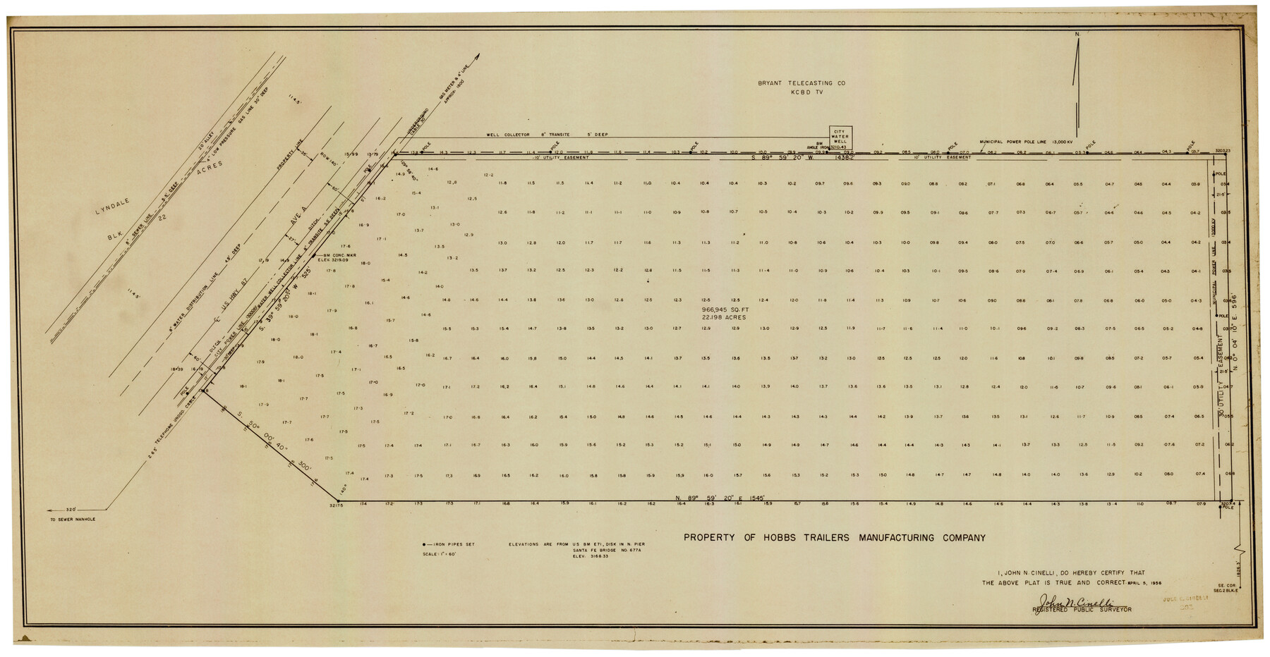
Property of Hobbs Trailers Manufacturing Company
-
Map/Doc
92733
-
Collection
Twichell Survey Records
-
Object Dates
4/5/1956 (Creation Date)
-
People and Organizations
John N. Cinelli (Surveyor/Engineer)
-
Counties
Lubbock
-
Height x Width
36.6 x 18.9 inches
93.0 x 48.0 cm
Part of: Twichell Survey Records
[Jones County School Land, Blocks P, D, D6, and CB]
![91091, [Jones County School Land, Blocks P, D, D6, and CB], Twichell Survey Records](https://historictexasmaps.com/wmedia_w700/maps/91091-1.tif.jpg)
Print $2.00
- Digital $50.00
[Jones County School Land, Blocks P, D, D6, and CB]
1907
Size 8.0 x 14.5 inches
Map/Doc 91091
[Capitol League Lands in SE corner of Lamb County and along the north line of Lamb and Bailey]
![90244, [Capitol League Lands in SE corner of Lamb County and along the north line of Lamb and Bailey], Twichell Survey Records](https://historictexasmaps.com/wmedia_w700/maps/90244-1.tif.jpg)
Print $20.00
- Digital $50.00
[Capitol League Lands in SE corner of Lamb County and along the north line of Lamb and Bailey]
Size 27.7 x 19.7 inches
Map/Doc 90244
[Area around Runnels County School Land and I. & G. N. Block 1]
![91664, [Area around Runnels County School Land and I. & G. N. Block 1], Twichell Survey Records](https://historictexasmaps.com/wmedia_w700/maps/91664-1.tif.jpg)
Print $20.00
- Digital $50.00
[Area around Runnels County School Land and I. & G. N. Block 1]
Size 23.0 x 17.9 inches
Map/Doc 91664
Ownership Map Midland Co., Texas

Ownership Map Midland Co., Texas
1951
Size 43.2 x 45.3 inches
Map/Doc 89914
Suburban Homes Addition

Print $2.00
- Digital $50.00
Suburban Homes Addition
1926
Size 12.9 x 9.2 inches
Map/Doc 92263
[Surveys along San Antonio Road]
![90110, [Surveys along San Antonio Road], Twichell Survey Records](https://historictexasmaps.com/wmedia_w700/maps/90110-1.tif.jpg)
Print $20.00
- Digital $50.00
[Surveys along San Antonio Road]
Size 23.0 x 13.7 inches
Map/Doc 90110
[W. T. Brewer: M. McDonald, Ralph Gilpin, A. Vanhooser, John Baker, John R. Taylor Surveys]
![90962, [W. T. Brewer: M. McDonald, Ralph Gilpin, A. Vanhooser, John Baker, John R. Taylor Surveys], Twichell Survey Records](https://historictexasmaps.com/wmedia_w700/maps/90962-1.tif.jpg)
Print $2.00
- Digital $50.00
[W. T. Brewer: M. McDonald, Ralph Gilpin, A. Vanhooser, John Baker, John R. Taylor Surveys]
Size 9.2 x 11.4 inches
Map/Doc 90962
[Wm. Baker and Chas. Lydings surveys and vicinity]
![92988, [Wm. Baker and Chas. Lydings surveys and vicinity], Twichell Survey Records](https://historictexasmaps.com/wmedia_w700/maps/92988-1.tif.jpg)
Print $2.00
- Digital $50.00
[Wm. Baker and Chas. Lydings surveys and vicinity]
Size 6.6 x 7.0 inches
Map/Doc 92988
[Gunter & Munson Maddox Bros. & Anderson Blocks F, O, N, A and vicinity]
![93203, [Gunter & Munson Maddox Bros. & Anderson Blocks F, O, N, A and vicinity], Twichell Survey Records](https://historictexasmaps.com/wmedia_w700/maps/93203-1.tif.jpg)
Print $40.00
- Digital $50.00
[Gunter & Munson Maddox Bros. & Anderson Blocks F, O, N, A and vicinity]
1929
Size 81.0 x 15.2 inches
Map/Doc 93203
Whitehead Second Addition

Print $20.00
- Digital $50.00
Whitehead Second Addition
Size 11.0 x 18.6 inches
Map/Doc 92879
[Sketch showing C. D. & W. A. Murphy's Pasture and Wint Barfield's Pasture]
![90885, [Sketch showing C. D. & W. A. Murphy's Pasture and Wint Barfield's Pasture], Twichell Survey Records](https://historictexasmaps.com/wmedia_w700/maps/90885-1.tif.jpg)
Print $20.00
- Digital $50.00
[Sketch showing C. D. & W. A. Murphy's Pasture and Wint Barfield's Pasture]
Size 31.9 x 27.4 inches
Map/Doc 90885
[Blocks M-22, M-25 and vicinity]
![91235, [Blocks M-22, M-25 and vicinity], Twichell Survey Records](https://historictexasmaps.com/wmedia_w700/maps/91235-1.tif.jpg)
Print $20.00
- Digital $50.00
[Blocks M-22, M-25 and vicinity]
Size 27.4 x 25.2 inches
Map/Doc 91235
You may also like
Flight Mission No. DQN-5K, Frame 145, Calhoun County

Print $20.00
- Digital $50.00
Flight Mission No. DQN-5K, Frame 145, Calhoun County
1953
Size 18.5 x 22.1 inches
Map/Doc 84420
Texas State Capitol Land

Print $40.00
- Digital $50.00
Texas State Capitol Land
1915
Size 76.6 x 55.6 inches
Map/Doc 93156

[San Antonio & Aransas Pass R.R. Right of Way from Eagle Lake to Brazos River]
![64256, [San Antonio & Aransas Pass R.R. Right of Way from Eagle Lake to Brazos River], General Map Collection](https://historictexasmaps.com/wmedia_w700/maps/64256.tif.jpg)
Print $40.00
- Digital $50.00
[San Antonio & Aransas Pass R.R. Right of Way from Eagle Lake to Brazos River]
1895
Size 30.8 x 124.9 inches
Map/Doc 64256
Pecos County Working Sketch 61

Print $20.00
- Digital $50.00
Pecos County Working Sketch 61
1952
Size 28.4 x 22.7 inches
Map/Doc 71533
Starr County Rolled Sketch 40

Print $20.00
- Digital $50.00
Starr County Rolled Sketch 40
1961
Size 21.3 x 22.6 inches
Map/Doc 7834
Ochiltree County

Print $20.00
- Digital $50.00
Ochiltree County
1958
Size 44.4 x 35.5 inches
Map/Doc 95603

Andrews County Rolled Sketch 9

Print $20.00
- Digital $50.00
Andrews County Rolled Sketch 9
1930
Size 25.3 x 43.6 inches
Map/Doc 77160
Houston, Texas (Looking South)

Print $20.00
Houston, Texas (Looking South)
1891
Size 25.3 x 41.1 inches
Map/Doc 89094
Kleberg County Rolled Sketch 10-40

Print $20.00
- Digital $50.00
Kleberg County Rolled Sketch 10-40
1952
Size 38.1 x 34.0 inches
Map/Doc 9392
Brazos River, East Waco Sheet

Print $6.00
- Digital $50.00
Brazos River, East Waco Sheet
1928
Size 31.6 x 25.9 inches
Map/Doc 65283