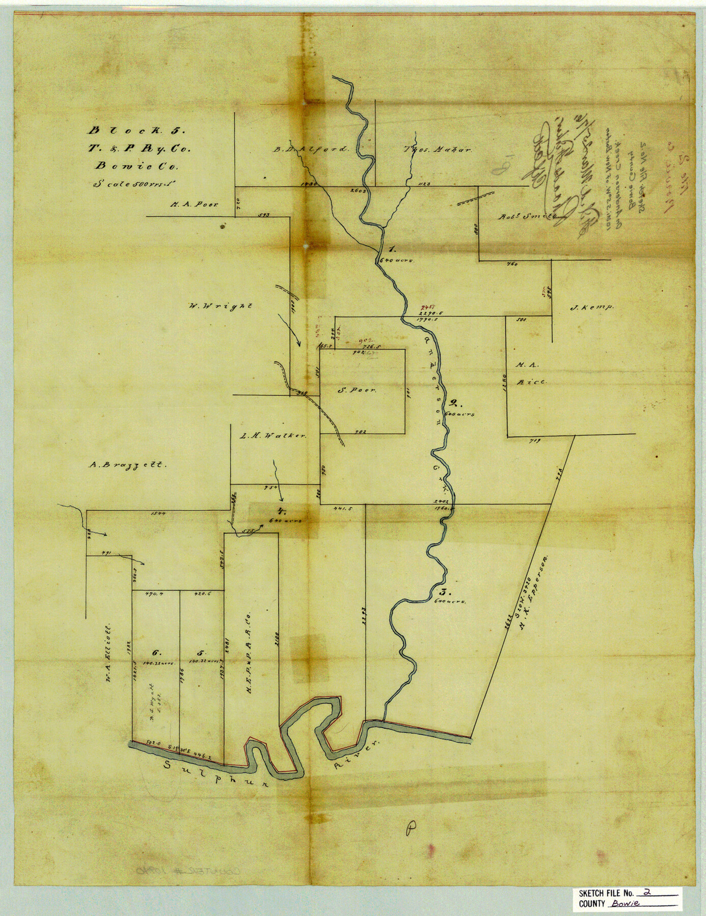
Bowie County Sketch File 2
Block 5, T. & P. Ry. Co., Bowie Co. [along Anderson Creek north of Sulphur River]
-
Map/Doc
10940
-
Collection
General Map Collection
-
Object Dates
1876/3/25 (File Date)
-
Counties
Bowie
-
Subjects
Surveying Sketch File
-
Height x Width
19.6 x 15.1 inches
49.8 x 38.4 cm
-
Medium
paper, manuscript
-
Scale
1" = 500 varas
-
Features
Anderson Creek
Sulphur River
Part of: General Map Collection
Current Miscellaneous File 40

Print $10.00
- Digital $50.00
Current Miscellaneous File 40
Size 14.2 x 8.7 inches
Map/Doc 73972
Coleman County Sketch File 20

Print $4.00
- Digital $50.00
Coleman County Sketch File 20
1871
Size 12.9 x 8.0 inches
Map/Doc 18694
Rains County Working Sketch 8

Print $20.00
- Digital $50.00
Rains County Working Sketch 8
1965
Size 24.3 x 28.1 inches
Map/Doc 71834

Coke County Rolled Sketch 5

Print $20.00
- Digital $50.00
Coke County Rolled Sketch 5
1948
Size 25.5 x 23.6 inches
Map/Doc 5505
Maverick County Sketch File 17

Print $20.00
- Digital $50.00
Maverick County Sketch File 17
Size 15.4 x 18.2 inches
Map/Doc 12052
Titus County Sketch File 1

Print $4.00
- Digital $50.00
Titus County Sketch File 1
Size 13.3 x 8.2 inches
Map/Doc 38130
Tom Green County Sketch File 55 1/2

Print $20.00
- Digital $50.00
Tom Green County Sketch File 55 1/2
1886
Size 26.4 x 13.6 inches
Map/Doc 12443
Hemphill County Working Sketch 38

Print $20.00
- Digital $50.00
Hemphill County Working Sketch 38
1982
Size 29.9 x 27.8 inches
Map/Doc 66133
Arroyo Colorado, La Feria Sheet

Print $40.00
- Digital $50.00
Arroyo Colorado, La Feria Sheet
1929
Size 24.6 x 58.5 inches
Map/Doc 65128
Flight Mission No. DQN-2K, Frame 72, Calhoun County

Print $20.00
- Digital $50.00
Flight Mission No. DQN-2K, Frame 72, Calhoun County
1953
Size 18.6 x 22.3 inches
Map/Doc 84264
Flight Mission No. BRA-6M, Frame 81, Jefferson County

Print $20.00
- Digital $50.00
Flight Mission No. BRA-6M, Frame 81, Jefferson County
1953
Size 18.6 x 22.6 inches
Map/Doc 85425
You may also like
Robertson County Sketch File 6

Print $4.00
Robertson County Sketch File 6
1870
Size 8.9 x 7.6 inches
Map/Doc 35362
Kendall County Sketch File 29

Print $14.00
- Digital $50.00
Kendall County Sketch File 29
1990
Size 14.0 x 8.5 inches
Map/Doc 95291
Topographical Map of the country between San Antonio & Colorado Rivers in the State of Texas.

Print $40.00
Topographical Map of the country between San Antonio & Colorado Rivers in the State of Texas.
1864
Size 53.3 x 69.2 inches
Map/Doc 88604
[Map of Matagorda County Showing Abandoned Surveys]
![2066, [Map of Matagorda County Showing Abandoned Surveys], General Map Collection](https://historictexasmaps.com/wmedia_w700/maps/2066.tif.jpg)
Print $40.00
- Digital $50.00
[Map of Matagorda County Showing Abandoned Surveys]
1920
Size 50.3 x 40.2 inches
Map/Doc 2066
Parkland Place, An Addition to Muleshoe

Print $20.00
- Digital $50.00
Parkland Place, An Addition to Muleshoe
1955
Size 39.2 x 30.3 inches
Map/Doc 92531

McCulloch County Working Sketch 8

Print $20.00
- Digital $50.00
McCulloch County Working Sketch 8
1977
Size 22.5 x 19.8 inches
Map/Doc 70683
Dimmit County Working Sketch 54

Print $20.00
- Digital $50.00
Dimmit County Working Sketch 54
1996
Size 27.8 x 30.0 inches
Map/Doc 68715
Irrigation in West Texas - the Pecos and Toyah Valleys

Irrigation in West Texas - the Pecos and Toyah Valleys
1912
Size 9.3 x 4.5 inches
Map/Doc 97072
Guadalupe County Working Sketch 2

Print $20.00
- Digital $50.00
Guadalupe County Working Sketch 2
1925
Size 37.2 x 19.2 inches
Map/Doc 63311
Henderson County Working Sketch 1

Print $40.00
- Digital $50.00
Henderson County Working Sketch 1
Size 52.6 x 43.8 inches
Map/Doc 66134
Presidio County Sketch File 73

Print $11.00
- Digital $50.00
Presidio County Sketch File 73
1944
Size 11.4 x 8.8 inches
Map/Doc 34682