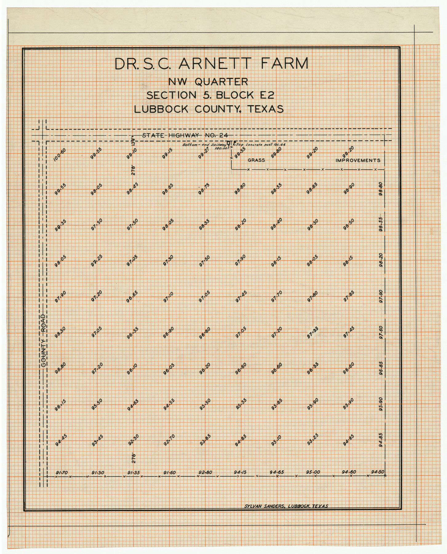
Dr. S. C. Arnett Farm Part Section 5, Block E2
-
Map/Doc
92296
-
Collection
Twichell Survey Records
-
People and Organizations
Sylvan Sanders (Surveyor/Engineer)
-
Counties
Lubbock
-
Height x Width
12.7 x 15.8 inches
32.3 x 40.1 cm
Part of: Twichell Survey Records
[H. & G. N. RR. Company, Block B3]
![90718, [H. & G. N. RR. Company, Block B3], Twichell Survey Records](https://historictexasmaps.com/wmedia_w700/maps/90718-1.tif.jpg)
Print $20.00
- Digital $50.00
[H. & G. N. RR. Company, Block B3]
Size 34.9 x 28.8 inches
Map/Doc 90718
[Area north of League 1, Morris County School Land]
![90351, [Area north of League 1, Morris County School Land], Twichell Survey Records](https://historictexasmaps.com/wmedia_w700/maps/90351-1.tif.jpg)
Print $20.00
- Digital $50.00
[Area north of League 1, Morris County School Land]
Size 12.9 x 14.1 inches
Map/Doc 90351
[Sketch in Crosby County]
![89759, [Sketch in Crosby County], Twichell Survey Records](https://historictexasmaps.com/wmedia_w700/maps/89759-1.tif.jpg)
Print $40.00
- Digital $50.00
[Sketch in Crosby County]
Size 54.6 x 46.5 inches
Map/Doc 89759
[H. & G. N. Block 28]
![90344, [H. & G. N. Block 28], Twichell Survey Records](https://historictexasmaps.com/wmedia_w700/maps/90344-1.tif.jpg)
Print $20.00
- Digital $50.00
[H. & G. N. Block 28]
Size 25.1 x 31.2 inches
Map/Doc 90344
[Parts of Public School Land Blocks 39, 31, C-40, C-42, E. L. & R. R. Blocks H, I]
![91271, [Parts of Public School Land Blocks 39, 31, C-40, C-42, E. L. & R. R. Blocks H, I], Twichell Survey Records](https://historictexasmaps.com/wmedia_w700/maps/91271-1.tif.jpg)
Print $20.00
- Digital $50.00
[Parts of Public School Land Blocks 39, 31, C-40, C-42, E. L. & R. R. Blocks H, I]
Size 14.2 x 19.5 inches
Map/Doc 91271
Block 10, Deshazo, Borden County

Print $20.00
- Digital $50.00
Block 10, Deshazo, Borden County
Size 18.3 x 25.5 inches
Map/Doc 92127
Cecil Stein Drilling Block

Print $3.00
- Digital $50.00
Cecil Stein Drilling Block
1951
Size 12.3 x 9.5 inches
Map/Doc 92280
Working Sketch in Hale County

Print $3.00
- Digital $50.00
Working Sketch in Hale County
Size 16.4 x 11.8 inches
Map/Doc 90746
[C. C. Slaughter Block 1, T. T. RR. Co. Block 2]
![90621, [C. C. Slaughter Block 1, T. T. RR. Co. Block 2], Twichell Survey Records](https://historictexasmaps.com/wmedia_w700/maps/90621-1.tif.jpg)
Print $2.00
- Digital $50.00
[C. C. Slaughter Block 1, T. T. RR. Co. Block 2]
Size 8.6 x 11.5 inches
Map/Doc 90621
Combination Map of Henderson, Kaufman, Rains, Van Zandt, Hunt & Rockwall Counties

Print $40.00
- Digital $50.00
Combination Map of Henderson, Kaufman, Rains, Van Zandt, Hunt & Rockwall Counties
Size 42.6 x 64.8 inches
Map/Doc 89810
Wilson Strickland Survey, Exhibit A

Print $20.00
- Digital $50.00
Wilson Strickland Survey, Exhibit A
Size 20.8 x 23.0 inches
Map/Doc 91368
[Land on East Side of Creek, Exhibit G]
![91372, [Land on East Side of Creek, Exhibit G], Twichell Survey Records](https://historictexasmaps.com/wmedia_w700/maps/91372-1.tif.jpg)
Print $20.00
- Digital $50.00
[Land on East Side of Creek, Exhibit G]
Size 19.4 x 29.6 inches
Map/Doc 91372
You may also like
Runnels County Rolled Sketch 23

Print $20.00
- Digital $50.00
Runnels County Rolled Sketch 23
Size 21.8 x 27.0 inches
Map/Doc 7514
El Paso County Sketch File 26

Print $20.00
- Digital $50.00
El Paso County Sketch File 26
Size 24.8 x 21.9 inches
Map/Doc 11457
Ward County Rolled Sketch 20

Print $20.00
- Digital $50.00
Ward County Rolled Sketch 20
1950
Size 27.4 x 22.7 inches
Map/Doc 8162
Plat Showing Theoretical Original City Limits of Corpus Christi

Print $20.00
- Digital $50.00
Plat Showing Theoretical Original City Limits of Corpus Christi
Size 41.3 x 41.7 inches
Map/Doc 4838
Stonewall County Sketch File 8

Print $14.00
- Digital $50.00
Stonewall County Sketch File 8
1896
Size 8.7 x 7.7 inches
Map/Doc 37222
Cooke County Boundary File 3

Print $4.00
- Digital $50.00
Cooke County Boundary File 3
Size 7.3 x 8.7 inches
Map/Doc 51853
McLennan County Sketch File 15

Print $4.00
- Digital $50.00
McLennan County Sketch File 15
1872
Size 8.2 x 11.3 inches
Map/Doc 31274
Galveston County Sketch File 17

Print $2.00
- Digital $50.00
Galveston County Sketch File 17
1893
Size 10.5 x 8.9 inches
Map/Doc 23387
Flight Mission No. CUG-1P, Frame 21, Kleberg County

Print $20.00
- Digital $50.00
Flight Mission No. CUG-1P, Frame 21, Kleberg County
1956
Size 18.5 x 22.2 inches
Map/Doc 86111
Flight Mission No. DQN-2K, Frame 121, Calhoun County

Print $20.00
- Digital $50.00
Flight Mission No. DQN-2K, Frame 121, Calhoun County
1953
Size 16.3 x 16.3 inches
Map/Doc 84297
Flight Mission No. CLL-3N, Frame 35, Willacy County

Print $20.00
- Digital $50.00
Flight Mission No. CLL-3N, Frame 35, Willacy County
1954
Size 18.3 x 22.1 inches
Map/Doc 87093
Tyler County Sketch File 16

Print $6.00
- Digital $50.00
Tyler County Sketch File 16
1860
Size 9.4 x 11.8 inches
Map/Doc 38661