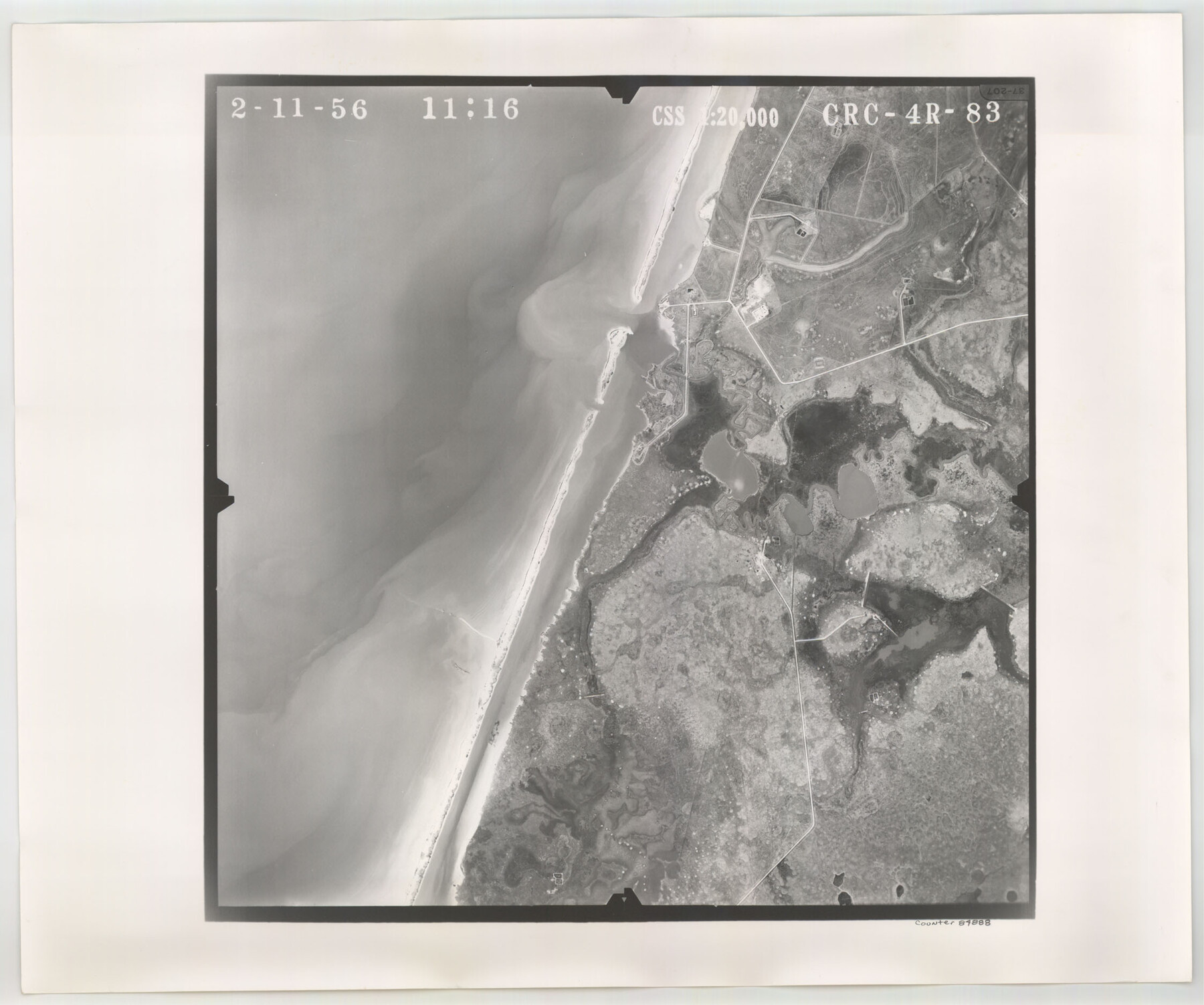
Flight Mission No. CRC-4R, Frame 83, Chambers County
CRC-4R-83
-
Map/Doc
84888
-
Collection
General Map Collection
-
Object Dates
1956/2/11 (Creation Date)
-
People and Organizations
U. S. Department of Agriculture (Publisher)
-
Counties
Chambers
-
Subjects
Aerial Photograph
-
Height x Width
18.8 x 22.5 inches
47.8 x 57.2 cm
-
Comments
Flown by Jack Ammann Photogrammetric Engineers, Inc. of San Antonio, Texas.
Part of: General Map Collection
Bailey County Sketch File 6

Print $40.00
- Digital $50.00
Bailey County Sketch File 6
Size 26.5 x 31.9 inches
Map/Doc 10884
Jeff Davis County Rolled Sketch 23

Print $20.00
- Digital $50.00
Jeff Davis County Rolled Sketch 23
1886
Size 24.9 x 25.4 inches
Map/Doc 7715
Flight Mission No. CRC-3R, Frame 100, Chambers County

Print $20.00
- Digital $50.00
Flight Mission No. CRC-3R, Frame 100, Chambers County
1956
Size 18.6 x 22.3 inches
Map/Doc 84838
Schleicher County Rolled Sketch 8

Print $20.00
- Digital $50.00
Schleicher County Rolled Sketch 8
Size 27.8 x 29.0 inches
Map/Doc 7750
Colorado River Project - Texas, Marshall Ford Dam right of way survey

Print $20.00
- Digital $50.00
Colorado River Project - Texas, Marshall Ford Dam right of way survey
1937
Size 22.1 x 42.0 inches
Map/Doc 3151
Dallas County Sketch File 21

Print $22.00
- Digital $50.00
Dallas County Sketch File 21
1888
Size 14.2 x 8.9 inches
Map/Doc 20443
Dickens County Rolled Sketch P

Print $20.00
- Digital $50.00
Dickens County Rolled Sketch P
1917
Size 41.2 x 36.9 inches
Map/Doc 8782
Sherman County Boundary File 4

Print $54.00
- Digital $50.00
Sherman County Boundary File 4
Size 8.9 x 8.5 inches
Map/Doc 58782
[Sketch for Mineral Application 1112 - Colorado River, H. E. Chambers]
![65635, [Sketch for Mineral Application 1112 - Colorado River, H. E. Chambers], General Map Collection](https://historictexasmaps.com/wmedia_w700/maps/65635.tif.jpg)
Print $40.00
- Digital $50.00
[Sketch for Mineral Application 1112 - Colorado River, H. E. Chambers]
1918
Size 25.8 x 48.1 inches
Map/Doc 65635
[Surveys possibly in Austin County]
![78356, [Surveys possibly in Austin County], General Map Collection](https://historictexasmaps.com/wmedia_w700/maps/78356.tif.jpg)
Print $3.00
- Digital $50.00
[Surveys possibly in Austin County]
Size 17.0 x 9.6 inches
Map/Doc 78356
Val Verde County Working Sketch 113

Print $40.00
- Digital $50.00
Val Verde County Working Sketch 113
2003
Size 54.9 x 34.6 inches
Map/Doc 78492
Jeff Davis County Working Sketch 27

Print $20.00
- Digital $50.00
Jeff Davis County Working Sketch 27
1960
Size 18.1 x 24.3 inches
Map/Doc 66522
You may also like
Map of Burnet County

Print $20.00
- Digital $50.00
Map of Burnet County
1876
Size 24.5 x 21.3 inches
Map/Doc 3352
Dimmit County Sketch File 20a

Print $2.00
- Digital $50.00
Dimmit County Sketch File 20a
Size 9.3 x 4.3 inches
Map/Doc 21103
[T.& P.R.R.Co., Block 1]
![92963, [T.& P.R.R.Co., Block 1], Twichell Survey Records](https://historictexasmaps.com/wmedia_w700/maps/92963-1.tif.jpg)
Print $20.00
- Digital $50.00
[T.& P.R.R.Co., Block 1]
Size 37.5 x 31.6 inches
Map/Doc 92963
Red River County Sketch File 15

Print $4.00
- Digital $50.00
Red River County Sketch File 15
1863
Size 12.1 x 7.2 inches
Map/Doc 35137
Tyler County Sketch File 24

Print $16.00
- Digital $50.00
Tyler County Sketch File 24
1944
Size 11.2 x 9.0 inches
Map/Doc 38681
The Republic County of Gonzales. January 29, 1842

Print $20.00
The Republic County of Gonzales. January 29, 1842
2020
Size 14.7 x 21.7 inches
Map/Doc 96157
Flight Mission No. BQR-12K, Frame 44, Brazoria County

Print $20.00
- Digital $50.00
Flight Mission No. BQR-12K, Frame 44, Brazoria County
1952
Size 18.8 x 22.4 inches
Map/Doc 84059
Donley County Sketch File 20 (6a)

Print $20.00
- Digital $50.00
Donley County Sketch File 20 (6a)
Size 20.1 x 13.1 inches
Map/Doc 11367
Wharton County Sketch File 11

Print $4.00
- Digital $50.00
Wharton County Sketch File 11
1891
Size 9.1 x 12.3 inches
Map/Doc 39933
Limestone County Sketch File 10b

Print $22.00
- Digital $50.00
Limestone County Sketch File 10b
1875
Size 15.0 x 14.1 inches
Map/Doc 30175
Working Sketch Carson County

Print $3.00
- Digital $50.00
Working Sketch Carson County
1907
Size 10.6 x 17.1 inches
Map/Doc 90223
Kleberg County Rolled Sketch 5

Print $20.00
- Digital $50.00
Kleberg County Rolled Sketch 5
Size 27.8 x 21.8 inches
Map/Doc 6548